|
THE ARCTIC NORTH POLE
|
|||||
|
JUNE 2013
Russia suspended the program until 2003, but has maintained one floating station at a time since then. Not long after North Pole 40 was established, it became apparent that the ice island would not survive for an extended period. Plans were made to move to another ice island, to be called North Pole 41 in September 2013. The transfer was to be accomplished in an orderly fashion by means of a long-range helicopter making a series of flights. All that changed rapidly this spring, as the ice island on which North Pole 40 began eroding with the warming Arctic weather.
Large chunks of ice have broken off the island, which is now only about ten feet thick under the research facility. The nuclear icebreaker Yamal has been dispatched on an emergency rescue mission to retrieve the 16 persons and as much equipment as possible. Evacuation by airplane is not possible because there is no longer enough level ice for a landing strip. As the ice island currently is in waters north of the Canadian Archipelago, it is out of land-based helicopter range.
Once evacuated, the research facility will be relocated ashore in the Severnaya Zemlya archipelago. A major US attempt to establish a floating research facility in the Arctic started just after World War II. It was called T-3 or Fletcher’s Ice Island and was in operation (on and off) for 22 years until it finally was reduced in size and drifted out into the North Atlantic – but that was long before climate change.
Rossiya
left Murmansk on the 15th of January 2013 to take the trip along the coast of Norway and through the narrow Øresund between Sweden and Denmark to the Gulf of Finaland, where it will be deployed until the end of April to assist commercial shipping during the winter navigation.
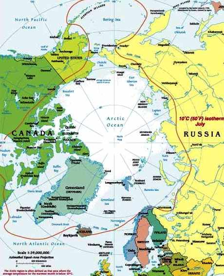
Arctic is the area around the Earth's North Pole, opposite the Antarctican area around the South Pole. The Arctic includes parts of Canada, Greenland (a territory of Denmark), Russia, United States (Alaska), Iceland, Norway, Sweden and Finland, as well as the Arctic Ocean.
There are numerous definitions of the Arctic region. The boundary is generally considered to be north of the Arctic Circle (66° 33’N), which is the limit of the midnight sun and the polar night. Other definitions are based on climate and ecology, such as the 10°C (50°F) July isotherm, which also roughly corresponds to the tree line in most of the Arctic. Socially and politically, the Arctic region includes the northern territories of the eight Arctic states, including Lapland, although by natural science definitions much of this territory is considered subarctic.
The Arctic is mostly a vast, ice-covered ocean, surrounded by treeless, frozen ground. It teems with life, including organisms living in the ice, fish and marine mammals, birds, land animals and human societies.
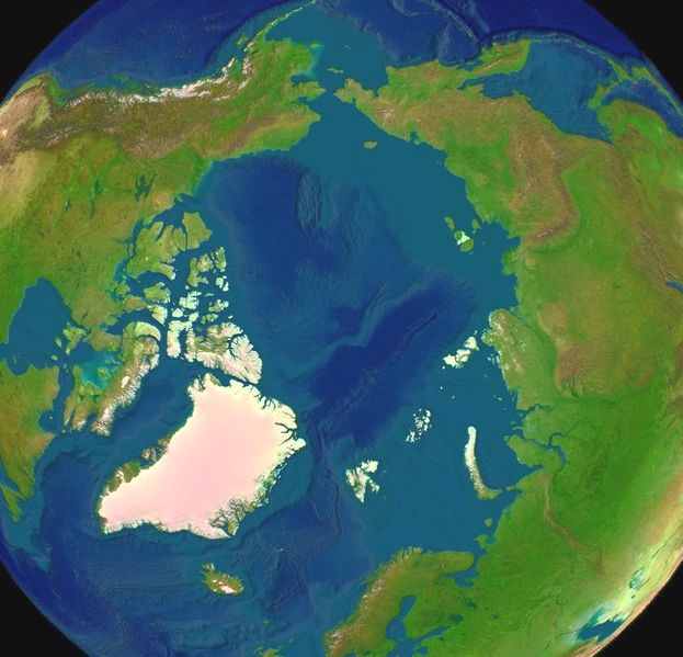
Arctica - North Pole from space
The Arctic region is, by its nature, a unique area. The cultures in the region and the Arctic indigenous peoples have adapted to its cold and extreme conditions. From the perspective of the physical, chemical and biological balance in the world, the Arctic region is in a key position. It reacts sensitively particularly to changes in the climate, which reflect extensively back on the global state of the environment. From the perspective of research into climatic change, the Arctic region is considered an early warning system.
The name Arctic comes from the ancient Greek αρκτος, meaning 'bear', and is a reference to the constellations of the Great Bear and Little Bear, which are located near the North Star.
Pollution
Nature in the Arctic is comparatively clean although there are certain ecologically difficult localized pollution problems that present a serious threat to people’s health living around these pollution sources. Due to the prevailing worldwide sea and air currents, the Arctic area is the fall out region for long-range transport pollutants and in some places the concentrations exceed the levels of densely populated urban areas. An example of this is the phenomena Arctic Haze, which is commonly blamed on long-range pollutants.
Nature and natural resources
The Arctic region includes sizeable potential natural resources (oil, gas, minerals, forest - if the subarctic is included - and fish) to which modern technology and the opening up of Russia have given significant new opportunities. The interest of the tourism industry in the cold and exotic Arctic is also on the increase. This is for example, seen in the rise in international tourism as a significant opportunity but also as a threat.
The Arctic region is one of the last and most extensive continuous wilderness areas in the world and its significance in preserving biodiversity and genotypes is considerable. The increasing presence of people fragments vital habitats. The Arctic is particularly susceptible to the abrasion of groundcover and to the disturbance of the rare reproduction places of the animals that are characteristic to the region.
Environmental impact assessment
From the perspective of positive development in the Arctic region, an environmental impact assessment (EIA) is in a key position. In the Arctic region, it is important that in a process, special attention is given to assessing social impacts. It is generally known that scientific information focused on the Arctic region is insufficient, so the actors conducting an EIA do not get sufficient material in order to compile a precise assessment.
Developing a dialogue between new actors in the region, business life and the local population is important so that mutual understanding and often conflicting needs for development can be improved. Improving access to information by local inhabitants, well functioning participatory planning, and ensuring the optimum use of its results are part of this activity. The horizontal processing of administration by different sectors in society that is required for an EIA necessitates for its support the production of strong multidisciplinary information. Managing and analyzing the above-mentioned multidimensional and demanding process requires combining many scientific fields and methods and further scientific analysis and development of functional models.
Map of the Arctic Circle
International cooperation and politics
The Arctic region is one of the important focuses of international political interest. International Arctic cooperation got underway on a broad scale well over ten years ago. The International Arctic Science Committee (IASC), hundreds of scientists and specialists of the Arctic Council, the Barents Council and its regional cooperation have compiled high quality information on the Arctic. Canada (citing the Law of the Sea) claims control over the waterways throughout the area.
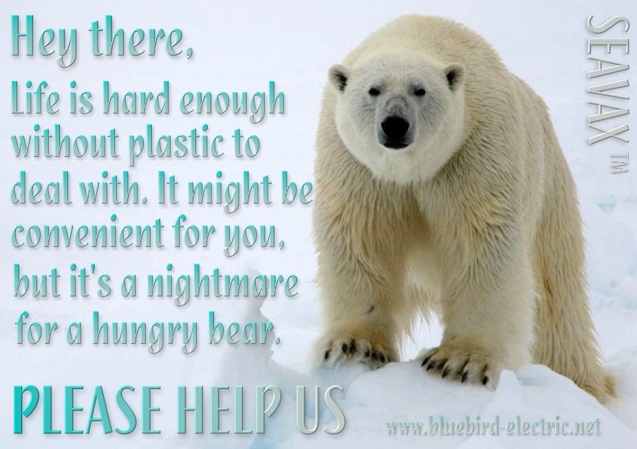
Plastic pollution has reached the Arctic and Antarctic regions, killing the wildlife upon which larger predators like the polar bear rely on for food. We are working on a vehicle that could help clean Arctic waters, by sweeping the 5 main ocean gyres of the majority of garbage. You can make a difference immediately, by disposing of your plastic waste responsibly, and by contributing to organisations that will help fund our not for profit research.
Polar bears live in one of the planet's coldest environments and depend on a thick coat of insulated fur, which covers a warming layer of fat. Fur even grows on the bottom of their paws. The bear's stark white coat provides camouflage in surrounding snow and ice. But under their fur, polar bears have black skin—the better to soak in the sun's warming rays. Polar bears are powerful predators that do not normally fear humans, which can make them dangerous. Near human settlements, they often acquire a taste for garbage, bringing bears and humans dangerously close, and putting the bears at risk from toxic waste.
Over 80% of marine pollution comes from land-based activities. From plastic bags to pesticides - most of the waste we produce on land eventually reaches the oceans, either through deliberate dumping or from run-off through drains and rivers. Plastic garbage, which decomposes very slowly, is often mistaken for food by marine animals. High concentrations of plastic material, particularly plastic bags, have been found blocking the breathing passages and stomachs of many marine species, including whales, dolphins, seals, puffins, and turtles. Plastic six-pack rings for drink bottles can also choke marine animals. This garbage can also come back to shore, where it pollutes beaches and other coastal habitats.
A strategic military region
Some countries claim the Arctic has never been under the political control of any nation, although some nations' militaries have attached a strategic importance to the region. Canada has an outpost in the region (Alert), and has long laid claim to much of the Arctic. Several recent excursions by the Canadian navy have taken place, with more planned to underline Canadian sovereignty in the region. In the 1950s and 1960s, the arctic was often used by submarines to test new weapons, sonar equipment, and depth testing.
During the Cold War, the Arctic region was extensively monitored by the United States military and NATO, since it was believed that the first warnings of a nuclear strike from the Soviet Union would have been indicated by ICBMs launched over the North Pole towards the United States. The United States placed such importance on the region that two military decorations, the Arctic Service Ribbon and Coast Guard Arctic Service Medal, were established for military duty performed within the Arctic Circle.
In 2006, Envisat and EOS Aqua revealed a polar route connecting Spitzbergen and Siberia. Increased Russian activity has also been detected though this can be attributed to the Chelyuskin icebreaker wreck expeditionary force.
LINKS and REFERENCE
LINKS:
Solar Cola drinkers care about planet earth
.. Thirst for Life
(330ml Planet Earth can)
The Arctic North Pole
A heartwarming adventure: Pirate whalers V Conservationists, with an environmental message.
|
|||||
|
This website is Copyright © 1999 & 2024 Max Energy Ltd. The bird logos and name Solar Navigator are trademarks. All rights reserved. All other trademarks are hereby acknowledged. Max Energy Limited is an educational charity working hard for world peace.
|