|
CAPE YORK - AUSTRALIA SUNSHINE ROUTE
|
|||||||||||||||||||||||||||||||||||||||||||||||||||||||||||||||||||||||||||||||||||||||||||||||||||||||||||||||||||||||||||||||||||||||||||||||||||||||||||||
|
Cape York is a large area of undeveloped land located in North Queensland, Australia. It is a wilderness area of incredible contrasts, dusty tracks, abundant river systems, crystal clear creeks and spectacular waterfalls. There are breathtaking beaches, rich rainforest areas supporting varied fauna and flora, From the wild untamed bush to the friendliness of the people of the Torres Strait, Cape York will surprise and delight any visitor. At this time Cape York is untouched, providing a valuable insight into this unique land mass that is steeped in beauty and history.
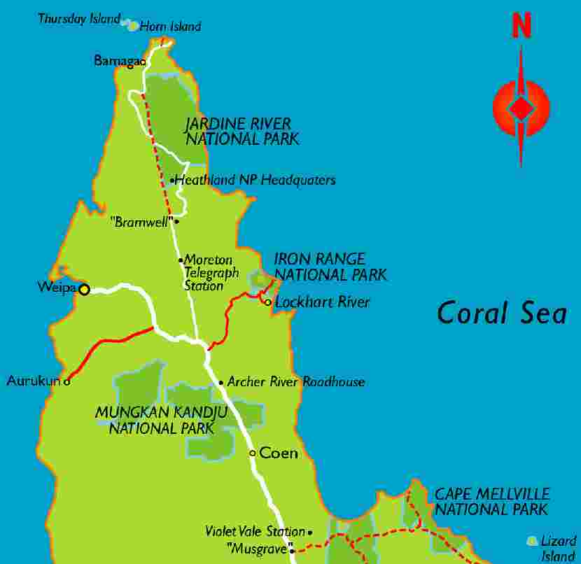
Map of Australia
The distance from Cairns to the tip of Australia is about 1,000 km where the finger of Cape York points to New Guinea which lies beyond the islands of the Torres Strait. On the Eastern side of the Peninsula from Cairns to Cooktown steep mountains clad in rainforest slope gently down to the ocean, this is where the rainforest meets the sea and the views over the barrier reef combined with the rich rainforest colours has to be one of the most spectacular sights you could ever see and is one of the most scenic areas in Australia.
Further north the country becomes much drier with sandstone & granite areas and hundreds of kilometres of wind swept beaches where time and tide have eroded cliffs into fascinating shapes. A belt of Limestone outcrops which were once coral reefs extend from Chillago to the North of the Palmer River. To the west rivers flow and emerge amongst the mangroves and join the grey waters of the Gulf of Carpentaria. The many National Parks are wide and varied, each having an unique value of it’s own.
There are only two seasons on Cape York Peninsula the "wet" and the "dry". The wet is by far the most spectacular, from mid November thunderstorms herald the beginning of the monsoonal rain. The parched land is replenished and the once dry rivers and creeks again flow. It is from now until perhaps April or May that the roads will become impassable and the only way to visit the Cape York region is by aircraft. This is also the cyclone season, with the right conditions they can form anywhere out to sea and cross the coast in varying intensity. At the end of the wet season the South East trade winds return drying the land, The once parched land is now green & lush and the wild flowers flourish.
The Aboriginal people have inhabited Australia for at least 40,000 years. The Cape York Aboriginal practiced tradition hunting well into the 1900’s. In the 1800’s Aboriginal people had increased contact with Europeans due to the establishment of fishing, pearling and pastoral interests.
For many years there was talk of establishing a settlement at the tip of Cape York and in 1863 a government regency was built at Somerset, In July 1864 Captain John Jardine, a police magistrate from Rockhampton arrived by ship to Somerset Bay to establish a settlement at Somerset.Seeing the need to be self sufficient in this remote area, Jardine obtained permission to herd cattle & horses overland.
Captain Jardines two eldest sons Frank & Alec would head the team on the drive and on the 11th October 1864 they set out from Carpentaria Downs Station near Rockhampton with 250 head of cattle and 41 horses. It proved to be one of the most incredible tests of endurance recorded in Australian exploration. Frank & Alec finally arrived at Somerset on 2nd March 1865. In recognition of his trek overland with the cattle, Frank Jardine was granted grazing land West of Somerset, the property was named "Lockerbie".
Lat 15.5 south Long 145.2 east
In 1877 the property at Somerset was abandoned with the administration being transferred to Thursday Island. Descendants of the Jardines lived in the residence for many years, then it was leased out and finally destroyed by fire in 1960 a sad end to a fine old Homestead.
Cooktown (including Lizard Island)
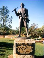
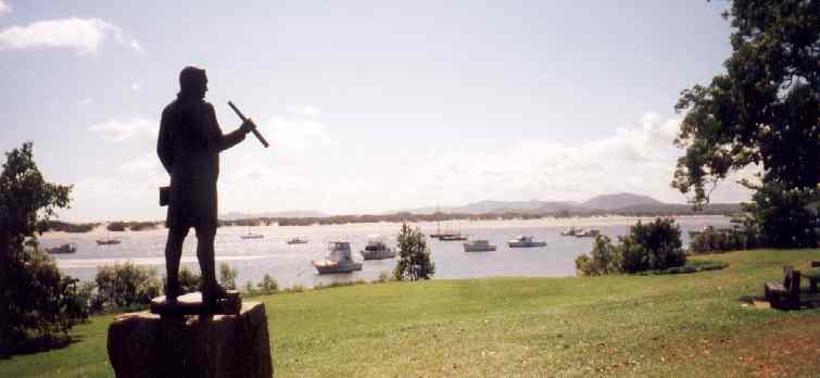
Cooktown wears its name with pride. It was the site of the first white 'settlement' in Australia when Captain James Cook, having accidentally struck the Great Barrier Reef off the coast north of Cape Tribulation, struggled up the coast and beached the H.M. Barque Endeavour on the shores of the Endeavour River. Cook and his crew were to stay on the river's edge from 17 June to 4 August, 1770: the greatest amount of time they were to spend at any one location in Australia.
There are no fewer than six monuments to Captain Cook in the town. However, his journals of the voyage do not return the compliment: '18 June 1770. I climbed one of the highest hills among those that overlooked the harbour, which afforded by no means a comfortable prospect; the lowland near the river is wholly overrun with mangroves, among which the saltwater flows every tide; and the high land appeared everywhere stony and barren. In the mean time, Mr Banks had also taken a walk up the country and met with the frames of several old Indian houses, and places where they had dressed shellfish.
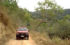
The road from Cooktown to Cape Tribulation
'30 June 1770. And went myself upon a hill which lies over the south point, to take a view of the sea. At this time it was low water and I saw, with great concern, innumerable sand banks and shoals lying all along the coast in every direction. The innermost lay about three or four miles from the shore, the outermost extended as far as I could see with my glass, and many of them did but just rise above water. There was some appearance of a passage to the northward and I had no hope of getting clear but in that direction; for as the wind blows constantly from S.E., it would be difficult, if not impossible, to return back to the southward.' Hardly a glowing recommendation.
After Cook came the coastal explorers Phillip Parker King and Allan Cunningham who explored the area in 1819 and climbed and named Mount Cook.
It wasn't until the discovery of gold on the Palmer River that any serious settlement was contemplated. The government, deciding the area needed a port, sent George Dalrymple to find a suitable location for one. However, events overtook both Dalrymple and the government when the Leichhardt arrived at Endeavour River with supplies and 96 people. Overnight the settlement of Cook's Town (as it was first called) grew up. This was a boom town. Within a few months there were over 500 tents and, by 1875, there were an incredible 65 hotels, a school, a fire brigade and two churches. The main street meandered on for nearly 3 km.
Some indication of the optimism which existed in the town at the time can be seen in the quality of the architecture invested in the James Cook Historical Museum building (1886) and the Westpac Bank building (1889).
The museum building was originally St Mary's Convent. A magnificent two-storey structure it was constructed in the belief that the town would become one of the great centres of Australia. At the time it was the second-largest city in Queensland. The elaborate cast-iron columns and balustrades reflect a sense of certainty which seems strange when observed from the Cooktown of a century later.
Similarly the Westpac Bank, with its superb cedar joinery and heavy masonry columns, suggests that the Queensland National Bank (which no longer exist) also believed in the future prosperity of the port. In many ways their belief was justified. At the time it was one of the busiest ports in Queensland.
The decline of the goldfields meant the decline of Cooktown. However, it had a sustained recovery when tin was found in the area and it maintained its status for some years when vessels would stop on their way from South-East Asia to the ports further down the coast.
Fortunes turned again in 1907 when a cyclone nearly destroyed the town. It had a brief recovery during World War II but it wasn't until the current North Queensland tourist boom that it began to achieve a level of success comparable with the 1870s and 1880s.
Captain Cook statue
Cooktown
Tourism Association
Cook Worship - Memorials and Lighthouse
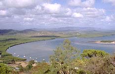
Even the town's lighthouse is dedicated to Captain Cook. A steep winding road leads to Grassy Hill which provides excellent views of the coast, the Endeavour River and Cooktown. At the top of the hill is another monument to Cook as well as the lighthouse. A nearby placard reprints a section from the Cooktown Courier of 5 August 1885 declaring: 'We understand that our lighthouse is on board the New Guinea which left Batavia on 27 July for Queensland ports. We have here another proof of the government's desire to deal fairly with us.
Before long the bright rays of our lighthouse will be gleaming over the waste of waters, carrying comfort and an assurance of safety to mariners who have to thread the intricate navigation of our coast...no better monument could be erected to the memory of Captain Cook. It is the one he himself would have chosen, as it will recall the gallant navigator and explorer everytime its bright tower of white light is seen.' As if all of these public declarations of admiration were not sufficient there is also the excellent James Cook Museum.
Other Memorials
The James Cook Museum
The museum recommends that each visitor spend at least an hour looking at the exhibits, which include a Chinese joss house (originally brought out from Canton), a shell collection, interesting material on Cooktown's early history, and artefacts from the Endeavour, including one of the cannons jettisoned from the vessel when it ran aground on Endeavour Reef, and one of the ship's anchors which was also recovered from the reef. The museum is open from 10.00am - 4.00pm each day, tel: (07) 4069 5386.
View of the Endeavour River and Cooktown
The Westpac Building
The Jacky Jacky Building
Cooktown Cemetery
There is also a Chinese Shrine. Over 20 000 Chinese passed through the town on their way to the goldfields and, at one time, Cooktown had a separate Chinatown with a permanent population of nearly 3000 people. Interestingly there is only one Chinese gravestone in the cemetery.
The Cooktown Sea Museum
Black Mountains National Park
Lizard Island
It was not until a century later that Captain Robert Watson with his wife, a servant and baby daughter, built a cottage on the island. The ruins are still visible. Captain Watson, was a beche-de-mer (sea cucumber) fisherman and during one of his absences Aborigines from the mainland attacked the cottage. Mrs. Watson, accompanied by her child and a Chinese servant, attempted to flee to the mainland in a barrel used for boiling beche-de-mer. The vessel floated away from the coast and all three died of thirst.
Cape Tribulation
In 1939 the island was declared a national park. Currently there is a resort catering for 60 guests and a research station. Regular flights to the island allow visitors an opportunity to wander the shores or to go bushwalking. Lizard Island is popular with deep-sea fishermen who use it as a base. Camping is allowed here as long as a permit has been issued (ring the Cairns office of the National Parks and Wildlife Service on (07) 4052 3096. The research station conducts tours every Monday and Friday, tel: (07) 4060 3977.
The Overland Telegraph Line
In the 1870’s other areas of the Cape saw incredible activity. After the discovery of gold in 1873 on the Palmer River a telegraph line connected Cooktown to Brisbane with a branch line linking Old Laura to Palmerville. In order to extend the electric telegraph line northwards a government surveyor was sent in 1883 to the Peninsula, his long arduous trek ended at Somerset. One year later the first section of the line was completed linking Fairview and Mein north of Coen, next the northern section of the line which ran through the country around the Jardine River was completed and a series of repeater stations were erected along the line. On the 23rd December 1886 Musgrave Station was opened and a few days later Coen. An underwater cable link to Thursday Island was also completed on the 25th August 1887 allowing communication to Brisbane by Morse code. The telegraph line opened in 1887 enabling the people of the Cape to overcome their loneliness, giving them a link with the outside world. Maintaining the line was a never ending job, 2 or 3 men were employed at each telegraph station and for over 60 years they patrolled the line North and South on horseback.
The last Morse telegram to be sent from Brisbane to Thursday Island was on 24th June 1964. then messages were sent by a teleprinter radio channel, making underwater cable obsolete. The telegraph line remained in service until 1987 and was used as a local telephone line before being dismantled. Today nearly all properties and settlements on Cape have an STD service through microwave towers scattered throughout the area. The telegraph track which it is now referred to still follows much of the original line north of Coen. This Four Wheel Drive track is the most exciting on the Cape as the many creeks you cross sometimes require winching and this is one of the main reason visitors come to this area. En Route Eliot Falls provide a great place for a swim with cascading water providing great relief after the hot dusty roads. Much evidence of those bygone days still exist and the track is thoroughly recommended not only for the adventure but its historic value.
The Significance of Cape York Peninsula
Wilderness Coast
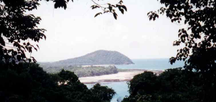
Cape York is fringed by 1800 kilometres of largely untouched wilderness coastline. Studies have confirmed the exceptional biological integrity of the peninsula's dunes, beaches and coastal zone. The most pristine section of the Great Barrier Reef lies off the cape's east coast, dotted with idyllic coral cays. Tens of thousands of migratory sea-birds spend the winter on the beaches and islands of the cape. Extensive sea-grass beds found along the east coast support one of the world's largest dugong populations.
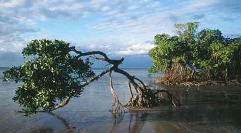
Cape York mangroves Elim Beach
The Cape York coast is enormously varied. Along the eastern side of the Cape, a visitor will find sweeping bays, rocky headlands, sandstone cliffs, mangrove-lined river mouths and massive white sand dunes. On the west coast, beside the Gulf of Carpentaria, there are shallow mud flats, as well as beaches overshadowed by red bauxite cliffs. The coast is exceptionally beautiful, and it provides increasingly rare undisturbed habitat for a whole host of coastal plants and animals.
Coastal dunes along Cape York support a beautiful and colourful variety of tropical vegetation. As well as the more familiar grasses, pandanus, casuarinas and rambling vines, there are patches of littoral rainforest hidden in gullies between dunes. In some places heathlands, wetlands or saltpans stretch out behind the dunes, while in other places the dunes are overtaken by dense rainforest.
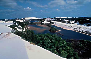
The major dunefields of Cape York – at Cape Flattery and Shelburne Bay – are internationally significant geological features. These dunes alone are as important as Fraser Island, and like at Fraser brown and blue freshwater lakes nestle among the dunes, home to unique freshwater fish. At Shelburne Bay there are over 100 square kilometers of sparkling white silica sand dunes and patches of towering, ancient hoop pine forest spring out of the white dunes – a relic from the age of the dinosaurs. On the beaches live some of the world's largest flocks of Beach Stone-curlews, Mongolian Plovers, Ruddy Turnstones, Grey-Tailed Tattlers, Pied and Sooty Oystercatchers, and Torresian Imperial Pigeons.
The coral cays beside Cape York are the most important known breeding grounds for many tropical ocean-going birds. Some seabirds stay all year round while others migrate from as far away as China and Russia to escape the northern winter. Wallace islet hosts Australia's largest breeding populations of the Roseate Tern, and Pelican Island is equally important for the Lesser Crested Tern.
During their breeding season, large ocean-going turtles also lay their eggs on the coral cays and isolated beaches of Cape York. The Flatback Turtle, Hawksbill turtle, and Green Turtle all nest in reasonable numbers on islands off the coast of Cape York, but are now rare elsewhere.
Extensive seagrass beds fringe parts of the east coast, particularly around Cape Melville, and Lookout Point. These seagrass beds are vital habitat for globally endangered dugongs. It's estimated that 8,000 dugong live along the Cape York coast – one of the world's largest, and most secure populations.
History and Geology
Around 8,000 years ago, when the sea level was lower, Cape York formed a land-bridge connecting the Australian mainland to Papua New Guinea. 16,000 years ago there was also a land link between Arnhem land and PNG, and the Gulf of Carpentaria was an enormous enclosed fresh-water lake. That's why many of the plants and animals on the cape can also be found in papua new guinea, while others have changed little since Australia was part of the super-continent Gondwana hundreds of millions years ago.
Most pure Silica sand dunes in the world
The Peninsula has at least four geological features that are nationally or internationally significant.
Eastern Dunefields
There are two large areas of pure white silica sand dunes on the east coast of Cape York - Shelburne Bay and the Cape Flattery-Cape Bedford dunefields. There is a sand mine on a small part of the Cape Flattery-Cape Bedford dunes, but 70% of the Shelburne Bay dunefields have high wilderness quality. There is little doubt that these tropical dunefields rival the temperate Fraser Island/Cooloola sand mass in both beauty and environmental importance. In both places, the vast expanse of white dunes is punctuated by perched freshwater lakes, and patches of vegetation, including towering Hoop Pine forests that are remnants from the time of the dinosaurs.
Cape Melville and Black Mountain
These two mountainous piles of gigantic black boulders are dramatic landmarks on the Cape. The granite boulders appear black because they are covered in dark blue-green algae. The rock formations are at least 225 million years old, and are the best and largest examples of their kind in Australia.
The Limestone Karsts
At the base of Cape York stretches a 100 kilometre long belt of scattered limestone outcrops called karsts. The karsts are the remains of ancient coral reefs, and they are riddled with fossils, caves and crevices. Rare vine thickets shelter among the karsts, while specially adapted animals like Godman's Rock Wallabies and Ghost Bats live in the caves and overhangs.
Princess Charlotte Bay Chenier Ridges
A series of parallel ridges fan inland from the coastline of Princess Charlotte Bay. These ridges represent prior shorelines, and are known as cheniers. Each new ridge was formed after a change in the local environment. They are the result of storms, the movement of the river mouth, falling sea levels and climatic changes. For scientists, the ridges provide a record of the area's geological history, and evidence of changes in the global climate over tens of thousands of years.
References: Mackey, Nix and Hitchcock (2001) 'The Natural Heritage Significance of Cape York Peninsula' Queensland Government, Brisbane (pp50-60); Frith and Frith (1995) 'Cape York Peninsula – A Natural History' Reed Books, Chatswood; Mulvaney, Abrahams, Glasco and Bugg (1995) 'Areas of Conservation Significance on Cape York Peninsula', Australian Heritage Commission, Canberra.
Cooktown overlooked by statue of Captain Cook
LINKS:
Resort
Bamaga
Bamaga Island Council Details on council services.
SeaSwift
- SeaLink Passenger Services
Wild
Lime Media
Cairns
OnLine
Visit
Torres Strait Business web sites
Lewis A Collins, Photographer, Model & Talent Library
Government web sites Department of Primary Industries - Cooktown profile Department of Local Government and Planning - Shire information
Tourism web sites Tourism Queensland - Travel site North Qld Tourism Data Service Holiday NQ - tourism information Cairns Connect website - town profile
Home
| About
Us | Learn
about Meteorology | Contacts
| Search
| Help
| Feedback
A heartwarming adventure: Pirate whalers V Conservationists, with an environmental message.
Solar Cola drinkers care about planet earth
.. Thirst for Life
(330ml Planet Earth can)
|
|||||||||||||||||||||||||||||||||||||||||||||||||||||||||||||||||||||||||||||||||||||||||||||||||||||||||||||||||||||||||||||||||||||||||||||||||||||||||||||
|
This website is Copyright © 1999 & 2024 Max Energy Limited an educational charity working hard for world peace. The bird logos and names Solar Navigator, Blueplanet Ecostar and Utopia Tristar are trademarks. All rights reserved. All other trademarks are hereby acknowledged.
|