|
HISTORY of BONNEVILLE SALT FLATS
|
|||
|
HOME | BIOLOGY | FILMS | GEOGRAPHY | HISTORY | INDEX | MUSIC | THE BOAT | SOLAR BOATS | SPONSORS |
|||
|
The Bonneville Salt Flats of the western Great Salt Lake Desert were formed through the evaporation of the Pleistocene-era Lake Bonneville. The salt flats are actually the bed of that once massive lake which rivaled in size present Lake Michigan. The flats are composed mainly of potash salts ranging in thickness from less than one inch to six feet.
Ancient Lake Bonneville
Although he never visited the salt flats, the area is named in honor of Captain B. L. E. Bonneville, whose expeditions in the 1830s proved the area was a part of the ancient basin.
During the last Ice Age, about 15,000 years ago, Lake Bonneville was the size of Lake Michigan. It covered one-third of present day Utah and parts of neighboring states. You can see traces of the shorelines, representing different levels of the receding lake, etched into the mountains surrounding the salt flats.
The Bonneville Salt Flats and the Great Salt Lake are remnants of ancient Lake Bonneville. Wind and water combine to create the flat surface of salt. Each winter, a shallow layer of standing water floods the surface of the salt flats. During spring and summer, the water slowly evaporates while winds smooth the surface into a vast, nearly perfect, flat plain.
The salt surface contains potassium, magnesium lithium, and sodium chloride (common table salt).
In 1827, trapper, trader, explorer, and frontiersman Jedediah Smith was perhaps the first white man to cross the salt flats in 1827 while returning from his first expedition to California. Six years later, Joseph Reddeford Walker, another trapper, mapped and explored the areas around the Great Salt Lake and crossed the northern perimeter of the flats while in the employ of Captain Benjamin L. E. Bonneville. It is from Benjamin Bonneville that the salt flats and prehistoric lake derive their name, although it is unlikely that Bonneville himself ever saw the flats
In 1845, John C. Fremont and his expedition crossed through the very heart of the salt flats in an effort to find a shorter overland route to the Pacific. In the following year, Fremont's route across the flats would come to be known as the Hastings Cutoff.
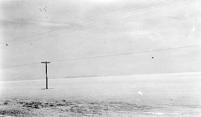
The way the salt flats looked from U.S. 40 in 1924 is
remarkably similar to how it looks today from I-80
The Cutoff, promoted by Lansford Hastings as a faster and easier route to California, proved to be just the opposite for the ill-fated Donner-Reed party of 1846. A factor contributing to the Donner-Reed tragedy in the Sierra Nevadas was the delay the party experienced on the salt flats when their wagons became mired in the mud found just below the thin salt crust. Abandoned wagon parts from the party were present on the flats well into the 1930s, and the wheel tracks of their wagons were still visible in 1986 when archaeologists examined several sites associated with the party.
The tragedy of the Donner-Reed Party inhibited extensive use of the Hastings Cutoff as an overland migration trail. The salt flats did, however, yield scientific information to the expeditions of Captain Howard Stansbury in 1849 and of Captain J.H. Simpson in 1859, both with the U.S. Army Corps of Topographical Engineers.
Fifty years after the Donner-Reed party slogged their way across the flats, the area's first use as raceway was conceived by publisher William Randolph Hearst in a publicity stunt. Hearst hired William Rishel of Cheyenne, Wyoming, to attempt a crossing on bicycle. Rishel completed the journey, crossing the salt flats in 22 hours.
A Barrier of Salt
Humans have lived in the Great Basin for thousands of years. Excavations at nearby Danger Cave have proven occupation of the area as early as 10,300 years ago. While Native Americans adapted to the desert environment, more recent arrivals found the area less hospitable.
By 1824, Jim Bridger and other mountain men explored the Great Salt Lake desert region. The first recorded crossing of the desert was made in 1845 by Captain John C. Fremont's survey party with scouts Kit Carson and Joe Walker. Early the next year, 23 year old Lansford Hastings retraced Fremont's train across the salt plain. Joe Walker's writings warned emigrants not to attempt the untried route, however, Hastings convinced several emigrant parties to follow him.
Despite Walker's warnings, the Donner-Reed party, seeking a shortcut to California in 1846, attempted the "Hastings' Cutoff." They failed to take enough water and lost a critical number of oxen. Four of their wagons were abandoned just 10 miles northeast of the salt flats. Time was lost, and the delay resulted in their late arrival to the Sierra Nevada Mountains and their tragic winter.
Late, in 1910, the first permanent crossing of the Bonneville Salt Flats was completed when the southern Pacific Railroad was built linking Salt Lake City and San Francisco.
Imagine a place so flat you seem to see the curvature of the planet, so barren not even the simplest life forms can exist. Imagine the passing thunder of strange vehicles hurtling by on a vast, dazzling white plain. This is to an alien world far from earth; it is Utah's famous Bonneville Salt Flats.
Early attempts to promote automobile racing failed until 1925 when Ab Jenkins, driving a Studebaker, beat a special excursion train by ten minutes in a race across the flats. Since that time the Bonneville Salt Flats have attracted racers from throughout the world and have become the site of numerous land speed records. Their attraction for these racers is due to the hard, flat surface expanse - in an area so flat that from certain perspectives the curvature of the earth can actually be seen.
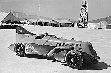
John Cobb's Napier-Railton which held the record of 134.85 mph for
a 24 hour period
The history of Utah motorsports is peppered with a variety of classes and styles of competition from grassroots drag racing up to nationally recognized stock racing. However, the greatest of these is the long tradition of competing for land speed records on the Bonneville Salt Flats. The following is from a postcard [P0591] about the famous Utahn Ab Jenkins and the salt flats; "The Bonneville Salt Flats is a salt deposit left by the receding of ancient Lake Bonneville. This deposit covers about 159 square miles extending some nine miles along U.S. Highways 40 and 50 and the Western Pacific Railroad.
The salt is white, crystalline aggregate, porous, hard and rigid so that it supports loaded trucks. In 1912 this area was tested as a race track and has since proved to be the greatests automobile speedway in the world. In 1931 Ab Jenkins of Salt lake City broke all former world speed records." In the years that followed, especially the 1950s and 1960s, the salt flats were a motorsports mecca. Today, hundreds of competitors arrive twice every year to attempt to break records. The following photographs and sounds document some of the work from the 1930s up to Speedweek, 1996.
For
sounds of the Salt Flats, the two links below will
connect you to two .wav audio files. The sounds bites
are taken from the Salt Lake City's KSL radio news
coverage of Captain Eyston's land speed record attempts
on the Bonneville Salt Flats in 1938. The radio program
was recorded onto 17 inch glass based acetate records by
the "instant recording" method. The particular
runs recorded were attempts made on August 24, 1938. A
mere three days later, Eyston's "Thunderbolt"
broke the land speed record by topping out at an
impressive 345.489mph! Click on the front of the vehicle
for the first run, (567k) and on the rear of the vehicle
for the return run, (385k). www.lib.utah.edu/spc/photo/bonn/EYSTON.WAV www.lib.utah.edu/spc/photo/bonn/EYSTON2.WAV
Racing for Speed
The Salt Flat's potential for racing was first recognized in 1896 by W.D. Rishel who was scouting a bicycle race course from New York to San Francisco. Rishel returned and convinced daredevil Teddy Tezlaff to attempt an automobile speed record on the flats. Tezlaff drive a Blitzen Benz 141.73 m.p.h. to set an unofficial record in 1914.
Typically, speed trials are scheduled throughout the summer and fall. The events are open to the public. For more information, contact the Bureau of Land Management, Salt Lake Field Office at (801) 977-4300.
Ab Jenkins 'Mormon Meteor' 1931
Visiting the Salt Flats
The Bonneville Salt Flats is administered by the Bureau of Land Management for public use and enjoyment. Due to its unique geology, history, and scenic beauty, the Bonneville Salt Flats was designated an Area of Critical Environmental Concern in 1985.
Help Preserve the Bonneville Salt Flats
Stay on existing roads or areas designated for vehicles. Despite the appearance of a hard surface, much of the area is a thin salt crust over soft mud. It easily breaks under the weight of a vehicle.
Stay off the salt surface when it is covered by water. When wet, the salt surface is soft and easily damaged by vehicles. Furthermore, the salt water is highly corrosive and can short-out the electrical system in your vehicle.
Be prepared for desert conditions. Temperatures can exceed 100 degrees in the summer and drop well below 0 in the winter. There are no facilities nor services on the salt flats. Temporary facilities are available during racing events.
Overnight stays are prohibited on the salt flats. Camping is encouraged on surrounding public lands. Private campgrounds and hookups are available in nearby Wendover, ten miles west of the Bonneville Salt Flats. Other accommodations and services are also available in Wendover.
For Additional Information Contact: Bureau
of Land Management
BONNEVILLE SALT FLATS FAMOUS UTAH LANDMARK
The Bonneville Salt Flats are a 121 km² (47 mi²) salt flat in northwestern Utah. A remnant of the ancient Lake Bonneville of glacial times, the Salt Flats are now public lands managed by the Bureau of Land Management.
The Salt Flats are perhaps most famous for their use as the Bonneville Speedway for high-speed race cars which have achieved speeds in excess of 600 miles per hour (1000 kilometers per hour). Several movies have been filmed at the salt flats, including portions of Independence Day, The Brown Bunny and The World's Fastest
Each rainfall erases tiremarks and flattens the densely-packed saltpan that is inhospitable to plantlife.
In 2006 the Stardust landed safely on the salt flats; however, in 2004 the Genesis crashed into it, damaging the spacecraft after a failed parachute deployment. Los Alamos National Laboratory stated that they should be able to meet many, if not all, of their primary science goals.
Bonneville Great Salt Lake Desert
One of the areas in the MMORPG World Of Warcraft is a possible homage to the flats. The area called "The Shimmering Flats" is located within the zone "Thousand Needles." It is a large salt flat in which the game's two engineer races, the goblins and gnomes, test and race rocket powered vehicles.
WHAT IS A SALT FLAT?
An alkali flat, also known as playa or sabkha, is a dry lakebed, generally the shore of, or remnant of, an endorheic lake. Such flats consist of fine-grained sediments infused with alkali salts. Their surface is generally very dry, hard and smooth in the summer months, but wet and very soft in the winter months. While the playa itself will be devoid of vegetation, they are commonly ringed by shadscale, saltbrush and other salt-tolerant plants that provide critical winter fodder for livestock and other herbivores.
Many playas contain shallow lakes in the winter, especially during wet years. If the layer of water is thin and is moved around the playa by the wind, an exceedingly hard and smooth surface can develop. Thicker layers of water can result in a "cracked-mud" surface. Too little water can result in dune formation.
The extremely flat, smooth, and hard surfaces of playas make them ideal surfaces for driving motor vehicles on. Large-sized playas are further excellent spots for pursuing land speed records, as the smoothness of the surface allows low-clearance vehicles to travel very fast without risk of disruption by surface irregularities, and the course of travel does not need to be too precise to avoid obstacles. The playas at Bonneville Salt Flats in Utah and Black Rock Desert in Nevada have both been used for setting land speed records. The latter is also the site of the annual Burning Man art and music festival.
Salar de Uyuni in Bolivia, near Potosí, is the largest salt flat in the world (12,000 km², about 300 times bigger than the Bonneville Salt Flats).
Terminology
The Spanish word playa (/ˈplaʝa/) literally means "beach". Alkali flats are known by this name in some parts of Mexico and the western United States (pronounced /ˈplaɪə/). On the Llano Estacado and other parts of the Southern High Plains, playa refers to a playa lake, a smaller seasonal depression.
In Arabic, an alkali flat is called a sabkha (also spelled sabkhah, sometimes sebkha) or shott.
LAKE BONNEVILLE
Lake Bonneville was a prehistoric pluvial lake that covered much of North America's Great Basin region. Most of the territory it covered was in present-day Utah, though parts of the lake extended into present-day Idaho and Nevada. Formed about 32,000 years ago, it existed until about 16,800 years ago, when most of the contents of the lake were released through the Red Rock Pass in Idaho. Many of the unique geological characteristics of the Great Basin are due to the effects of the lake.
The Great Salt Lake is a remnant of the original Lake Bonneville. Several levels of the old shorelines are still visible above Salt Lake City, along the Wasatch Front and elsewhere. Its appearance is that of a shelf or bench protruding from the mountainside, well above the valley floor. Four main shorelines are associated with the fluctuating levels of the ancient lake. The Stansbury, Bonneville, Provo and Gilbert shorelines each mark a time when lake level remained constant long enough to deposit massive accumulations of sand and gravel.
The Bonneville Bench, at approximately 1,555 m (~5,100 ft.) elevation, is part of the preserved ice age shoreline. This shoreline marks the highest level attained by the Pleistocene lake approximately 15,500 years ago. During this period, the lake covered over 52,000 km² (20,000 square miles ) and was over 300 m (1000 ft.) deep in places.
About 14,500 years ago, the lake level fell catastrophically as Lake Bonneville overflowed near Red Rock Pass, Idaho. The lake level fell some 105 m (~350 ft.) to what is now the next lower bench (the "Provo level") in a flood that geologists estimate to have lasted up to a year. The Provo level is the most easily recognized shoreline feature throughout the valley and is distinguished by thick accumulations of tufa that formed nearshore during the 500 years that the lake was at this level.
About 14,000 years ago, the lake started to drop again due to changing climate conditions, and by 12,000 years ago, the lake reached a level even lower than that of the modern day Great Salt Lake. A slight transgression or rise in lake level occurred about 10,900 to 10,300 years ago and formed the Gilbert shoreline. The Gilbert shoreline is the least conspicuous of the major shorelines but evidence of it remains at Antelope Island and in large coastal features, such as the Fingerpoint Spit near the Hogup Mountains.
Lake Bonneville is named after Benjamin Louis Eulalie de Bonneville (1796–1878), a French-born officer in the United States Army, fur trapper, and explorer in the American West. Bonneville is noted for his expeditions to the Oregon Country and the Great Basin.
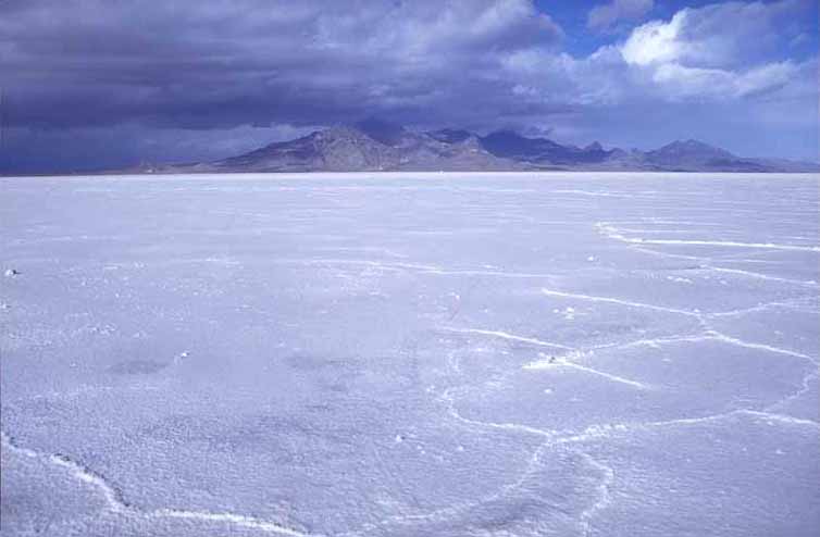
The Bonneville Salt Flats as seen from a rest area along Interstate 80
References
Utah History Encyclopedia
Solar Cola drinkers care about planet earth
.. Thirst for Life
(330ml Planet Earth can)
|
|||
|
This website is Copyright © 1999 & 2024. The bird logo and name Solar Navigator are trademarks. All rights reserved. All other trademarks are hereby acknowledged. Max Energy Limited is an educational charity.
|