BEACHY HEAD, EASTBOURNE, SUSSEX
HOME | BIOLOGY | FILMS | GEOGRAPHY | HISTORY | INDEX | INVESTORS | MUSIC | SOLAR BOATS | SPORT
Beachy Head, with its dramatic white cliffs and gently undulating downs, is an area of outstanding natural beauty and tranquillity which belies its proximity to the busy south eastern towns of England.
It is a haven for those who like to walk or cycle. It's also a great place for hang-gliding, mountain boarding, or for the rather less extreme sport of flying a kite. It is easy to reach for a holiday, a weekend or a day away.
There are many historic sites in the area, as well as pretty villages with good pubs, shops and restaurants to visit, and all within easy reach of the main towns of the region. For a complete change, visitors are welcome to spend some time at the farm or the sheep centre.
There is a choice of holiday accommodation and there are even facilities for a romantic wedding, guaranteed to be memorable for guests as well as the happy couple.
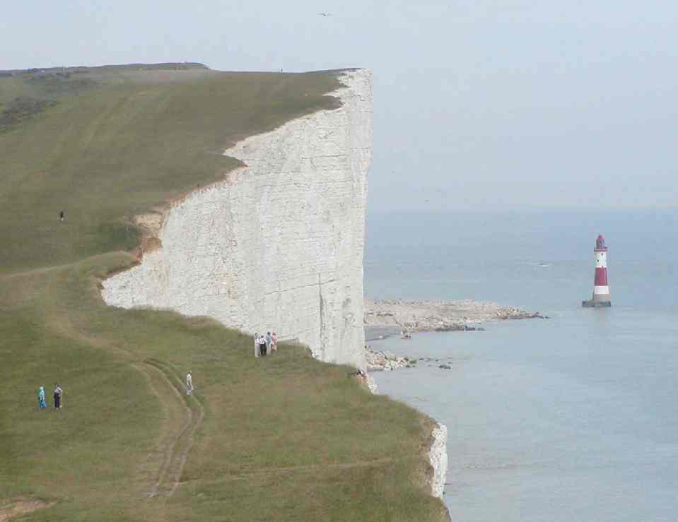
Beachy Head Lighthouse looking east
Beachy Head (grid reference TV587955) is a chalk headland on the south coast of England, close to the town of Eastbourne in the county of East Sussex. The cliff there is the highest chalk sea cliff in Britain, rising to 162 m (530 ft) above sea level. The peak allows views of the south east coast from Dungeness to the east, to Selsey Bill in the west.
The prominence of Beachy Head has made it a landmark for sailors in the English Channel. It is noted as such in the sea shanty Spanish Ladies:
-
The first land we sighted was called the Dodman,
Next Rame Head off Plymouth, off Portsmouth the Wight;
We sailed by Beachy, by Fairlight and Dover,
And then we bore up for the South Foreland light.
It was also a danger to shipping. The famous Belle Tout lighthouse built in 1831 is located near the edge of the cliff on the next headland west from Beachy Head. It was moved more than 17 m (50 ft) further inland in 1999 due to cliff erosion. The lighthouse was superseded by the newer Beachy Head Lighthouse, 43m in height, built in the sea below in 1902.
West from Belle Tout, the cliffs drop down to Birling Gap, and beyond that the Seven Sisters. The site is a popular tourist attraction and includes a restaurant and, in the summer heat, multiple ice cream vans. Beachy Head is notorious as a popular location for people to commit suicide. Actor David Scarboro, who originally played Mark Fowler in the popular British soap opera EastEnders, died there in 1988.
The third day of fighting in the Battle of Portland, 1653, took place off Beachy Head during the First Anglo-Dutch War. The Battle of Beachy Head, 1690, was a naval engagement during the War of the Grand Alliance. The chalk was formed in the Cretaceous period when the area was under the sea, 65 million years ago. Since then, earth movements have raised the chalk up to form the dramatic cliffs of the Sussex coast.
Beachy Head Lighthouse looking west
Beachy Head is the most famous part of the Eastbourne Downland. Beachy Head rises 162 metres (530 feet) above the sea below and is the highest chalk sea cliff in Britain.
The main reason for Beachy Head's popularity is the wonderful panoramic view which can be seen from the cliff top. If you look east you see the beaches and town of Eastbourne, the Pier and the Harbour, and then on to Pevensey Bay and Hastings and, on an exceptionally clear day, Dungeness in Kent, nearly 40 miles away.
Looking west, you can see even further, up to 70 miles, past Seaford Head to Newhaven and Brighton and then on to Selsey Bill near Chichester in West Sussex. On a very clear day the outline of the Isle of Wight can be seen.
Getting
There - Beachy Head is
easily reached by car. From Eastbourne take Duke's Drive from
the seafront (be careful of the steeply winding road), Meads
Road from Meads and East Dean Road from Old Town. From the west
follow the signs on the A259. Parking is free in the lay-bys
near Beachy Head and there is a large pay and display public car
park. Please park in the Beachy Head Pub car park only if you
intend to patronise the pub.
Eastbourne
Buses run a service along the seafront from the Sovereign
Centre to Beachy Head.
Facilities - There are public toilets adjoining the car park at Beachy Head, including disabled toilets (access with radar key). Beachy Head Pub is open all day, 7 days a week and serves good quality food. Children and disabled welcome, indoor and outdoor play equipment, toilet and baby changing facilities. Tel: 01323 728060.

Belle Toute Lighthouse - Bell Toot
Belle Toute
Belle Toute Lighthouse is situated on the cliff top about 2½ km west of Beachy Head.
It was built in the 1830's as a working lighthouse but was replaced in 1904 by the Beachy Head lighthouse as it was being obscured by fog. It has gained fame through the BBC drama The Lives and Loves of a She-Devil which was filmed there, and through a high profile move from the edge of the cliff in March 1999. It is the only residential lighthouse in the country.
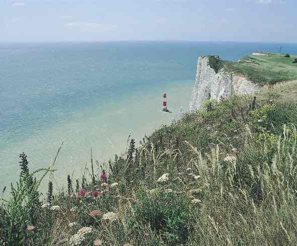
Beachy Head Lighthouse - Position 50° 44'.0 N 00° 14'.50 E
It
is said that as early as 1670 a light shone to guide passing
vessels from the top of the cliffs at Beachy Head, the 90 metres
high seaward termination of the Sussex Downs.
In 1828 James Walker erected Belle Toute Lighthouse, a 14 metre
high circular tower, on the headland. This remained in operation
till 1899 when it was abandoned due to being frequently shrouded
in mist and threatened with collapse because of recurrent falls
of chalk from the cliff.
In 1902 under the direction of Sir Thomas Matthews, the Trinity
House Engineer-in-Chief, the present lighthouse was brought into
service, sited about 165 metres seawards from the base of the
cliffs. It took two years to complete and involved building a
coffer-dam and a cableway from the top of the cliffs to carry
materials down to the site. 3,660 tons of Cornish granite were
used in the construction of the tower.
Beachy Head lighthouse was automated and de-manned in June 1983.
It is monitored 24 hours a day from the Trinity House Operations
Control Centre at Harwich in Essex.
Specifications
|
The Countryside Commission also designated the white chalk cliffs between Beachy Head and the Seven Sisters and Seaford Head as the first ever stretch of Heritage Coastline - a stretch of coastline which is of particular natural beauty or importance and is managed to preserve this largely undeveloped beauty.
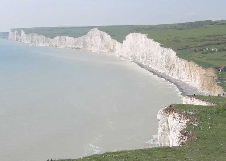
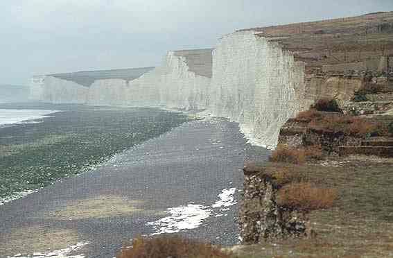
The Seven Sisters are a famous series of chalk cliffs by the English Channel. They form part of the South Downs in East Sussex, between the towns of Seaford and Eastbourne in southern England, and are within the Seven Sisters Country Park.
The number seven refers to the cliff peaks, which are individually named: from the west they are Haven Brow, Short Brow, Rough Brow, Brass Point, Flagstaff Point (continuing into Flagstaff Brow), Baily's Hill, and Went Hill Brow. Beyond, on the top of the next hill, is Belle Tout lighthouse. The dips between each Sister are also named: Short Bottom, Limekiln Bottom, Rough Bottom, Gap Bottom, Flagstaff Bottom, and Michel Dean. The South Downs Way runs along the edge of the cliffs, taking a very undulating course.
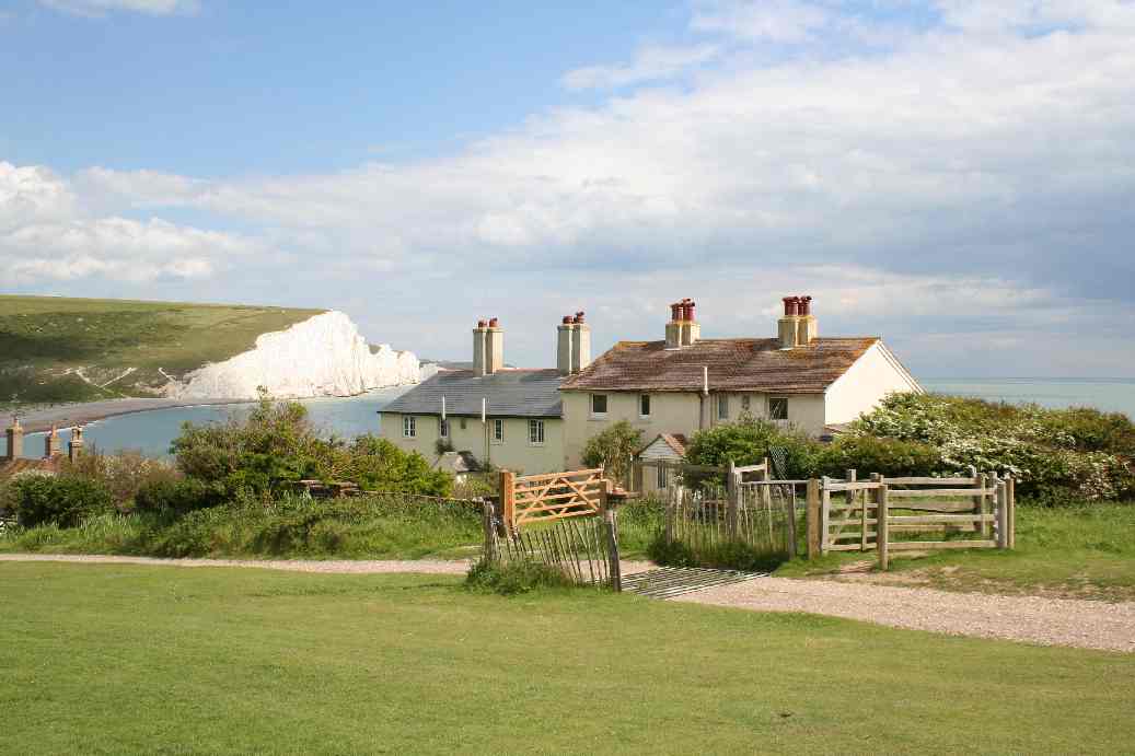
The Seven Sisters from Seaford Head coastguard cottages © 2006
BIRLING GAP
Birling Gap is a coastal hamlet in East Sussex on the South Downs between Eastbourne and Seaford It is situated on the Seven Sisters not far from Beachy Head and is owned by the National Trust.
Coastal erosion is a nationwide problem which locally, has already removed the hotel and some of the row of fishing cottages built in 1878. Today there is a cafe/tea room, and steps leading down to the beach and the Seven Sisters chalk cliffs. Although unofficial, it is rumoured that this beach is frequented by naturists or nudists, indeed, I once happened along such activities some years ago.
The residents of Birling Gap formed a Cliff Protection Association, after their local authority refused to grant planning permission for works to protect the buildings near the cliff edge. The then leader of the Wealden District Council, Valerie Chidson is reported to have lost her seat, after it was revealed that she had misreported facts to Committee in answer to a public question, concerning a legal opinion and the National Trust. It transpired that Wealden and the National Trust had jointly instructed counsel, whereas, previously this had been denied.
If you want to help the residents in their fight to save their homes, please visit their website which briefly outlines the history of Birling Gap and their efforts to convince the National Trust that the proposed sea defence of natural boulders, which will be covered by shingle, is the preferred solution to preserve the view, the charming Birling Gap hotel and other landmarks.
....and PEOPLE'S HOMES
LATEST
Please click the link below to read the 'officious' letter from;
Sarah Mann of the National Trust
and the reply from;
The bay at Birling Gap
BIRLING GAP - history and resident's struggle
1878; The Admiralty builds eight
Coastguard cottages at Birling Gap using a revolutionary
new material called 'no fines' concrete.
1898; A small hotel is opened at Birling Gap. Seven other residential properties were built in the early 1920's
1951; The cottages pass into private ownership but coastguards continue to man a station, sometimes risking their lives in sea and cliff-top rescues.
1973; The first cliff-edge cottage is demolished by Hailsham Council. At this point no-one was trying to save the cottages.
1983; The National Trust purchases Birling Gap for an undisclosed sum. This includes the Hotel, four of the remaining cottages, the car park and some downland.
1992; At the urging of the Ministry of Agriculture, Food and Fisheries, Wealden District Council commission an engineering study by marine engineers, Posford Duvivier, to investigate how to defend the hamlet of Birling Gap.
1993; Posford Duvivier recommend a rock 'revetment' at the base of the cliff as feasible, realistic and affordable.
1993; Wealden Council DECLINES to implement the report by Posford Duvivier !
1995; The second cottage is demolished by its owner, The National Trust, who evict the tenant just before Christmas! The adjoining cottage is damaged in the process.
1996; A new report with a detailed cost/benefit analysis shows that it would be economically advantageous to build a rock revetment.
1996; Birling Gap Cliff Protection Association formed.
1998; Environmental study reports revetment would cause minimal damage to the area. Legal opinion establishes National Trusts responsibility to safeguard its neighbours properties.
1999; nearly 50,000 signatures gathered to date from the public in support of a rock revetment scheme.

The Battle of Britain of the white cliffs
-
Letter by Lord Harris to each councillor regarding the anticipated rejection of the planning application (15/8/99)
-
Letter from Selsey Town Council to Wealden Council supporting the Planning Application
-
A copy of the Environmental statement sent by Alan Edgar to Wealden District Council regarding the planning application for the reduced size revetment
Did you know that the money The National Trust spent defending itself against responsibility for protecting the homes at Birling Gap, would probably have paid for a revetment double the length the residents asked for.
THE SOUTH DOWNS
In 1929 Eastbourne Borough Council purchased 4000 acres of the South Downs for a total of £91,291 - 1s - 7d. Part of the deal was that the Council, or Corporation as it was then known, would 'secure the public the free and open use of the Downs in perpetuity.' The Council remains committed to that promise and more than 1,200 acres are designated 'Open Downland' - free, open access land for the public to enjoy, whilst the rest is let to tenant farms.
The 4000 acres of land purchased by the Council - the Eastbourne Downland - is a triangular shaped landholding at the easternmost end of the South Downs. Its boundaries are marked by the Eastern Escarpment, the end of the Downs where the chalk hills meet Eastbourne, the Northern Escarpment, facing the Weald of Sussex, Willingdon Hill and East Dean in the West and the Southern Escarpment, which has been eroded by the seas to forms the famous white cliffs.
The Eastbourne Downland is visited by a million people every year, making it one of the country's most popular natural beauty spots. It offers fine views out to sea and inland, over the ridges and dry valleys, and is a rich source of wildlife. In September 1999 the Minister for Environment, Transport and the Regions asked the Countryside Agency to consider awarding the South Downs National Park status.
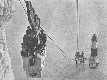
Cable car used to build Beachy Head Lighthouse
HISTORY AND GEOLOGY OF THE DOWNS
10,000 BC - The dry valleys, ridges and escarpments of the Eastbourne Downland were formed by glacial action during the Ice Age. The chalk of the cliffs, however, was formed over a period of 30 million years when a warm sub tropical sea covered the area, between 95-65 million years ago. The shells of billions of microscopic planktonic algae formed a deposit which eventually hardened into layers of white rock a thousand feet thick. This has since been uplifted due to continental movement and subsequent erosion has created the Downs seen today.
8,000 BC - End of Ice Age as temperatures increase. Sea levels rise and flood a valley to form the English Channel, enabling the sea to flood through to the South Downs. Marine erosion of cliffs begins. Mesolithic hunter gatherers explore the region.
4,000 BC - Neolithic Man attracted to the well-drained chalklands of the Eastbourne Downs which offer fertile grounds for crops. The area is gradually cleared of wild wood for grazing & crops. Flint tools from this period have been found in the area and there is a Neolithic causeway camp on Combe Hill upon the Northern Escarpment.
2,000-1,500 BC - Bronze Age peoples clear woodland to create space for settled agriculture - evidence of hut sites and domestic pottery found near Belle Tout. Numerous burial mounds, 'round barrows', are located upon the escarpment ridges.
600
BC - New, Iron Age settlements indicated by numerous
field banks in area, particularly at Bullock Down and near
Jevington.
50 BC - Romans take control of south east
England. Increasingly efficient farming - remains of Roman farm
found on Frost Hill.
400 AD - Romans leave Britain. Eastbourne Downland used for grazing.
1250 AD - Medieval farms and settlements established.
20th Century - Farm mechanisation and decline of traditional farming methods. Increased demand for food leads to loss of chalk grassland to intensive farming with the use of artificial fertilisers. The loss of traditional landscapes and habitats leads to the rise of the conservation movement in the late 20th Century and the protection of the Eastbourne Downland.
The chalk grassland cover of the Eastbourne Downland provides one of Britain's richest wildlife habitats with up to 40 plant species growing in one square metre of turf. The thin, poor quality soil encourages slow growing plants and the long history of sheep grazing, which continues today, has led to the development of the springy turf.
The downland supports a wide variety of plants which can only survive in chalky soils and also the butterflies and other insects that these plants attract.
The Eastbourne Downland is conserved following the decline of chalk grassland during the middle of the 20th century due to increased food production and the use of pesticides and other chemicals in arable farming. A decline in grazing animals - sheep due to a decline in sheep farming, and rabbits due to myxomatosis - meant that much of the chalk grassland was taken over by coarse grasses, scrub and pioneer woodland. After the Second World War large areas of chalk grassland were ploughed up for arable farming and in all 25% of the chalk grassland of the South Downs was lost between 1966 and 1980.
Eastbourne Borough Council today employs shepherds to tend the Council's flock of sheep which graze the Open Downland in the traditional manner in order to preserve and enhance it. Much of the tenant farmland is also now under grass, with the farmers supported by grant aid from the Ministry of Agriculture, Fisheries & Food (the ESA Scheme).
One of the most stunning aspects of the Eastbourne Downland is the Heritage Coastline of pure white chalk cliffs. The erosion of these cliffs by the sea is often thought of as a destructive process but it is this erosion which creates and maintains the cliffs' magnificent whiteness through constantly eroding the old cliff face and revealing the clean white chalk underneath.
The white cliffs of Beachy Head and the Seven Sisters have been eroding for at least 10,000 years, ever since the end of the last Ice Age. The base of the cliff is attacked with tremendous force at high tide as the waves break against the chalk. Shingle is also thrown at the cliff and pockets of air are trapped in the crevices and alternately compressed and decompressed.
These forces combine to erode a notch in the base of the cliff which eventually cannot support the upper parts of the cliff. The cliff is also weakened from the top during the winter as rain water in the soil freezes and expands, pushing the rock apart, and then thaws and runs through the crevices. A section of cliff then tumbles to the beach, creating a temporary defence against the waves until it is broken up and washed away.
One of the key conditions of the management of the Heritage Coast is that it is left undeveloped in order to preserve the landscape value. This means that no sea defences will be built to slow the natural process of erosion, not even to save existing buildings. Belle Toute Lighthouse was moved back from the cliff edge on March 24 1999 in order to save it from an imminent collapse into the sea.
The Heritage Coast recede an estimated average of about ½ -1 metre a year. Occasionally there will be a larger than average cliff fall, such as that on January 10 1999 when up to 6 metres of cliff edge tumbled away, to a depth of 17 metres over a 70 metre long stretch. As global warming continues and sea levels rise the rate of erosion is expected to increase and falls of this size will become increasingly common.

BEACHY HEAD AS A SUICIDE HOT SPOT
Beachy Head is a dramatic and beautiful chalk headland on the south coast of England. It is located 3 miles west of Eastbourne, and its summit extends 535 feet above the rising sea level.
The imposing cliff tops offer tourists clear views for miles around, but are famous for another more disturbing reason – they provide an irresistible draw for those intent on committing suicide.
Deaths
at Beachy Head
Eastbourne Parish Register contains entries of deaths at Beachy Head dating back to 1600 and by the middle of the 20th Century there were an average of 6-7 deaths p.a. At the tail-end of the 1990’s it had crept up to an average of 17 p.a.
Between the years 1965-1989, an in-depth study of deaths at Beachy Head was made by Dr. John Surtees (1997 pp. 125-136) – a cumulative total of 250. His research looked into the causes of death, injuries sustained, factors relating to the circumstances of the deaths and the resultant verdicts.
Fig 1. below illustrates total deaths at Beachy Head between 1965 and 1989, indicating the verdicts passed. It can be seen that the proportion of suicide and open verdicts fluctuates throughout, and can be attributed to some extent to inter-Coroner variation.
|
|
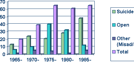
Fig
1. Deaths at Beachy
Head 1965-1989 (with Inquest Verdicts)
Why
Commit Suicide at Beachy Head?
If
most of the deaths occurring at Beachy Head are due to suicide,
why does the location present such a lure to desperate people?
It
is clear that deaths at Beachy Head attract local and
national publicity, and it has been shown that such publicity
results in suicidal mimicry (Gunnell 1994 pp.1446-7). The
lethality of injuries sustained from a 500 foot fall (Mason et
al 2000 pp.313-326) appeals to some, whilst the ease of access
(one can drive straight up to the edge in places) and lack of
preparation necessary appeals to others.
Conclusion
Beachy
Head is a dramatic natural landmark that draws tourists and
those intent on committing suicide alike.
Most deaths at Beachy Head display several circumstantial factors suggesting suicide. However, despite homicidal falls from a height traditionally being thought of as rare occurrences, some deaths at Beachy Head, raise considerable suspicion. A lack of physical evidence prevents such cases being proven to the criminal standard of proof, and the Coroner must be satisfied with passing an ‘open’ verdict.
1.
GUNNELL. D. (1994), ‘Reporting Suicide – The effect
of media coverage on patterns of self harm’, BMJ 308:
1446-47 1994
2.
MASON. J.K., PURDUE. B.N. (2000), ‘The Pathology of
Trauma’, Arnold Publishers
3.
SURTEES. S.J. (1997), ‘Beachy Head’, SB
Publications
The main reason for Beachy Head's popularity is the wonderful panoramic view which can be seen from the cliff top. If you look east you see the beaches and town of Eastbourne, the Pier and the Harbour, and then on to Pevensey Bay and Hastings and, on an exceptionally clear day, Dungeness in Kent, nearly 40 miles away. If you are feeling suicidal, lonely, or depressed, you may like to reflect on the outstanding natural beauty that surrounds us, of which Beachy Head is just one example. Such views are likely to mke you feel happier, maybe restore a sense of balance, or, you might be better off talking to someone about your problems. Anything is better than making the ultimate sacrifice. http://www.samaritans.org.uk/ Email: jo@samaritans.org

Chalk cliff slide at Beachy Head
LINKS:
SUSSEX INDEX A - Z
BEACHY HEAD - BELL TOOT (BELLE TOUT) LIGHTHOUSE
CHIDDINGLY - HORSE SHOW and GYMKHANA
CUCKMERE VALLEY - EXCEAT
EAST
SUSSEX
EASTBOURNE
- EASTBOURNE
PIER
HERSTMONCEUX - CASTLE - CE SCHOOL - LINKS - FESTIVAL
TWISSELLS MILL, OLD HEATHFIELD
|
Atlantis - Plato's Lost City
|
London - Big Ben London Houses Parliament London - Buckingham Palace London - Old Bailey London - Trafalgar Square Maya Empire - Central America
|
Sri Lanka - Links UAE - United Arab Emirates United Kingdom - Gov
|
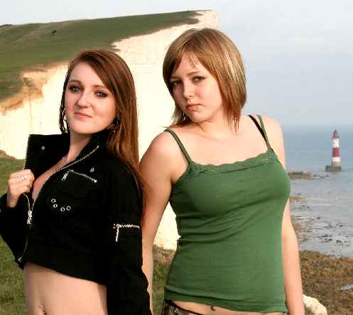
The Sunshine Girls living on the edge - Beachy Head that is!
Solar Cola drinkers care about planet earth
.. Thirst for Life

(330ml Planet Earth can)
This website is Copyright © 1999 & 2024. The bird logo and name Solar Navigator are trademarks. All rights reserved. All other trademarks are hereby acknowledged. Max Energy Limited is an environmental educational charity.