|
WORLD GEOGRAPHY A - Z ATLAS
|
|||||||||||||||||||||||||||||||||||||||||||||||||||||||||||||||||||||||||||||||||||||||||||||||||||||||||||||||||||||||||||||||||||||||||||||||||||||||||||||||||||||||||||||||||||||||||||||||||||||||||||||||||||||||||||||||||||||||||||||||||||||||||||||||||||||||||||||||||||||||||||||||||||||||||||||||||||||||||||||||||||||||||||||||||||||||||||||||||||||||||||||||||||||||||||||||||||||||||||||||||||||||||||||||||||||||||||||||||||||||||||||||||||||||||||||||||||||||||||||||||||||||||||||||||||||||||||||||||||||||||||||||||||||||||||||||||||||||||||||||||||||||||||||||||||||||||||||||||||||||||||||||||||||||||||||||||||||||||||||||||||||||||||||||||||||||||||||||||||||||||||||||||||||||||||||||||||||||||||||||||||||||||||||||||||||||||||||||||
|
The more we know about our precious blue planet, the better we can manage our future. Please use the links table below to explore the countries of the world and learn about our fellow man, their customs, needs and the land they inhabit.
This free A to Z resource features Youtube video footage from around the world and google map locations for easy reference. Isn't technology wonderful.
The design of the Elizabeth Swann, and world navigation route, are the subject of continuous development.
HYDROGEN/SOLAR (BUNKERED) CIRCUMNAVIGATION CHALLENGE:
HYDROGEN HYBRID TRANSIT EXAMPLES - The above table, when compared to the Solar route planner, shows us the difference in performance we might expect using hydrogen as the propulsive fuel, either in combination with solar power, or stand alone.
The hydrogen and solar powered Elizabeth Swann is capable of speeds above 18 knots in the right conditions.
|
|||||||||||||||||||||||||||||||||||||||||||||||||||||||||||||||||||||||||||||||||||||||||||||||||||||||||||||||||||||||||||||||||||||||||||||||||||||||||||||||||||||||||||||||||||||||||||||||||||||||||||||||||||||||||||||||||||||||||||||||||||||||||||||||||||||||||||||||||||||||||||||||||||||||||||||||||||||||||||||||||||||||||||||||||||||||||||||||||||||||||||||||||||||||||||||||||||||||||||||||||||||||||||||||||||||||||||||||||||||||||||||||||||||||||||||||||||||||||||||||||||||||||||||||||||||||||||||||||||||||||||||||||||||||||||||||||||||||||||||||||||||||||||||||||||||||||||||||||||||||||||||||||||||||||||||||||||||||||||||||||||||||||||||||||||||||||||||||||||||||||||||||||||||||||||||||||||||||||||||||||||||||||||||||||||||||||||||||||
|
ZERO CARBON GLOBAL CIRCUMNAVIGATION CHALLENGE
The Elizabeth Swan could circle the globe autonomously adding a new scientific dimension to an exciting hydrogen or solar powered expedition. As you can imagine, the planet's geography is pivotal to the planning of the route and the design of the ship. Many routes have been proposed, developed and investigated. The best example of which, and the most likely, is shown on this page, known as the 'Sunshine Route.' (Please note this project is under new management by a film company working with the Cleaner Ocean Foundation,, rather than just a navigation attempt.)
One of the most important factors to be considered is the safety of the ship and crew, but the Swan could complete this mission unmanned if so equipped and such technological innovation is well within our grasp.
Many tropical areas are only safe from storms for six months of the year and other areas are prone to piracy. Our route is west-about so as not to fight the prevailing winds on a course designed to capture the sun. The ships average performance will determine the time of the voyage and that depends on how much sunshine and wind energy it can capture.
Energy from the sun varies according to the angle of the incoming radiation. This radiated energy is called insolation and it is different for any position on earth at any given point in time. Thus, it is the position of the Elizabeth Swan on the earth's surface that determines how much energy the ship receives - even with the 'solar wings' tracking the sun.
The graph below was the development tool for designing the size of the 'solar wings' and the target weight of the boat. From the weight of the boat we can calculate drag - and from the drag we can calculate the energy we need to power the ship. Designing a boat is like a dog chasing its own tail. You have to start somewhere. Once you know the approximate figures, you can begin to tighten up the specification. A weight analysis is crucial. A weight analysis must include everything to make the ship complete. It's difficult. Any naval architect will tell you that. The ship is also the product of the mission. This particular mission is to go around the world in 280 days or under autonomously.
A GRAPH USED AS A DEVELOPMENT TOOL TO ESTIMATE SOLAR PANEL AREA FOR A GIVEN PERFORMANCE
This particular graph starts as the average insolation for each of the waypoints of the Sunshine Route. It's up to you how conservative your estimate is, but it is just that - an estimate. World insolation figures are available for many positions on earth, but not for the open ocean. There are other variables, for example the efficiency of your solar cells, and that comes down to cost. We have elected to build the Elizabeth Swan as economically as possible - and that means no exotic materials. This decision also makes us more attractive to project partners - and validates the commercial possibilities for solar powered cargo ships.
We hope you will in part experience the flavour of this exciting voyage from the destinations listed above and learn something of the exotic locations. The World is indeed our Oyster.
Records to beat:-
1. The electric Trans-World Ocean record - 585 days (571 days adjusted).
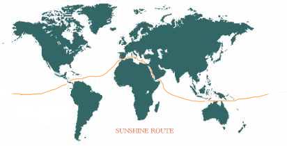
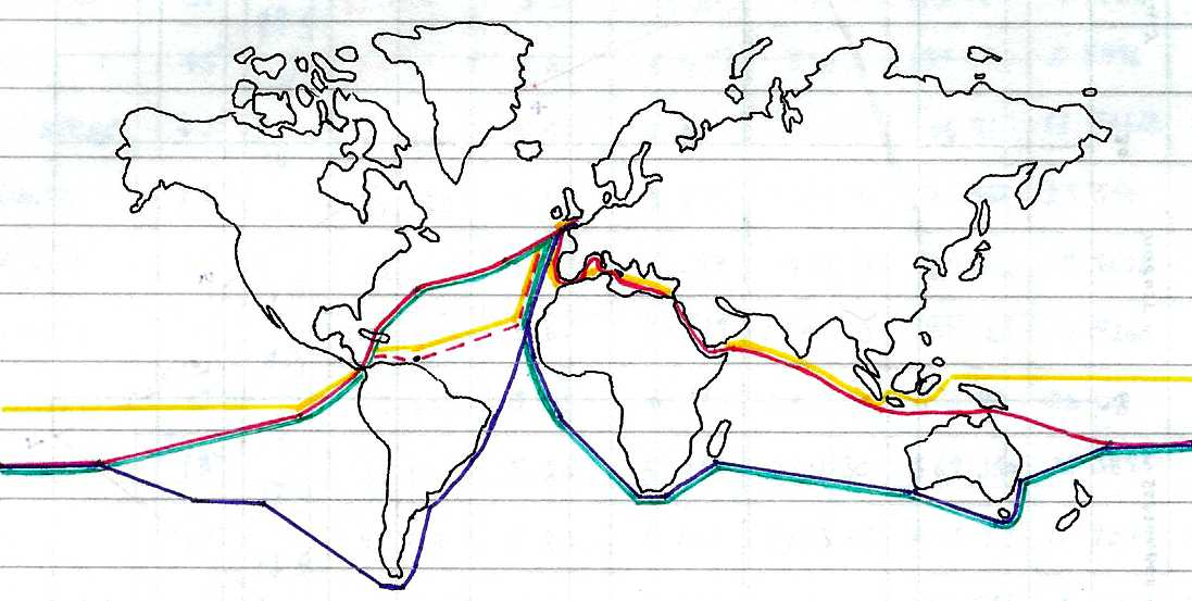
THE SUNSHINE ROUTE
Map study showing alternative routes investigated for a fast circumnavigation as the Gold (sunshine), Red, Green and Blue routes. The table below is for the Sunshine Route.
TRANSIT EXAMPLES - The above table illustrates one of the most likely ocean awareness expedition routes showing the time elapsed in days for 7 knots average cruising speed, including times for 5 and 6 knot averages - allowing for 10% downtime and 36 days in ports. Hence, although the objective is to reduce the current solar circumnavigation record from 584 days, the event in not an outright non-stop yacht competition in the offshore racing sense. It remains to be seen how accurate such a prediction might be.
A date for the start of the event has yet to be set, although it is hoped for a launch in 2021 and an attempt to set a number of records in 2022. Monaco is where the fun begins and ends. The route will encompass both great Canals. It is hoped to transit the Panama Canal in February heading for the Galapagos and thence joining the South Equatorial Current to Indonesia via the Torres Strait by August. Still going with the S.E. trades across the Indian Ocean, then through the Suez Canal to Port Said into the Mediterranean Sea to Palermo and Monaco, where it is hoped a new Guinness world records will be set. It is expected this expedition will last around 280 days, including around 60 days of docking for provisions, media and public relations events.
In addition to planning a route for good sunshine, it is an advantage to be able to tilt the ship's wing-panels towards the sun to collect as much energy from each daily pass. To do this we use a Solar Tracker. We also use electronic MMPT to ensure that each bank of panels is giving as much power as it can, while working with other banks of panels.
THE FUTURE
Eventually, it is hoped to be in a position to travel around the world in 80 days or less using energy from nature. We know that is a long way off, but if somebody does not try to raise the bar, we will never get there. For sure, as and when an autonomous navigation is safely completed, that will herald a new era of navigation precision. See the Jules Verne Hydrogen Trophy (JVH2).
ACIDIFICATION - ADRIATIC - ARCTIC - ATLANTIC - BALTIC - BAY BENGAL - BAY BISCAY - BERING - BLACK SEA - CARIBBEAN - CORAL - CORAL SEA - EAST CHINA SEA ENGLISH CH - FINLAND - GOC - GUANABARA - GULF GUINEA - GULF MEXICO - INDIAN - IRC - MEDITERRANEAN - NORTH SEA - PACIFIC - PERSIAN GULF - SEA JAPAN SOUTHERN -
AMAZON - BURIGANGA - CITARUM - CONGO - CUYAHOGA - GANGES - IRTYSH - JORDAN - LENA - MANTANZA-RIACHUELO MARILAO
- MEKONG - MISSISSIPPI
- NIGER -
NILE -
PARANA -
PASIG -
SARNO - THAMES
- YANGTZE
- YAMUNA -
YELLOW
|
|||||||||||||||||||||||||||||||||||||||||||||||||||||||||||||||||||||||||||||||||||||||||||||||||||||||||||||||||||||||||||||||||||||||||||||||||||||||||||||||||||||||||||||||||||||||||||||||||||||||||||||||||||||||||||||||||||||||||||||||||||||||||||||||||||||||||||||||||||||||||||||||||||||||||||||||||||||||||||||||||||||||||||||||||||||||||||||||||||||||||||||||||||||||||||||||||||||||||||||||||||||||||||||||||||||||||||||||||||||||||||||||||||||||||||||||||||||||||||||||||||||||||||||||||||||||||||||||||||||||||||||||||||||||||||||||||||||||||||||||||||||||||||||||||||||||||||||||||||||||||||||||||||||||||||||||||||||||||||||||||||||||||||||||||||||||||||||||||||||||||||||||||||||||||||||||||||||||||||||||||||||||||||||||||||||||||||||||||
|
This website is Copyright © 1999 & 2025 Cleaner Ocean Foundation Limited, an environmental educational charity working hard for world peace. The names AmphiMax™, SeaVax™, Elizabeth Swan™ and Kulo Luna™ are trademarks. All other trademarks are hereby acknowledged.
|
|||||||||||||||||||||||||||||||||||||||||||||||||||||||||||||||||||||||||||||||||||||||||||||||||||||||||||||||||||||||||||||||||||||||||||||||||||||||||||||||||||||||||||||||||||||||||||||||||||||||||||||||||||||||||||||||||||||||||||||||||||||||||||||||||||||||||||||||||||||||||||||||||||||||||||||||||||||||||||||||||||||||||||||||||||||||||||||||||||||||||||||||||||||||||||||||||||||||||||||||||||||||||||||||||||||||||||||||||||||||||||||||||||||||||||||||||||||||||||||||||||||||||||||||||||||||||||||||||||||||||||||||||||||||||||||||||||||||||||||||||||||||||||||||||||||||||||||||||||||||||||||||||||||||||||||||||||||||||||||||||||||||||||||||||||||||||||||||||||||||||||||||||||||||||||||||||||||||||||||||||||||||||||||||||||||||||||||||||