|
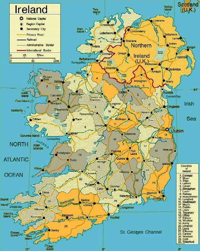
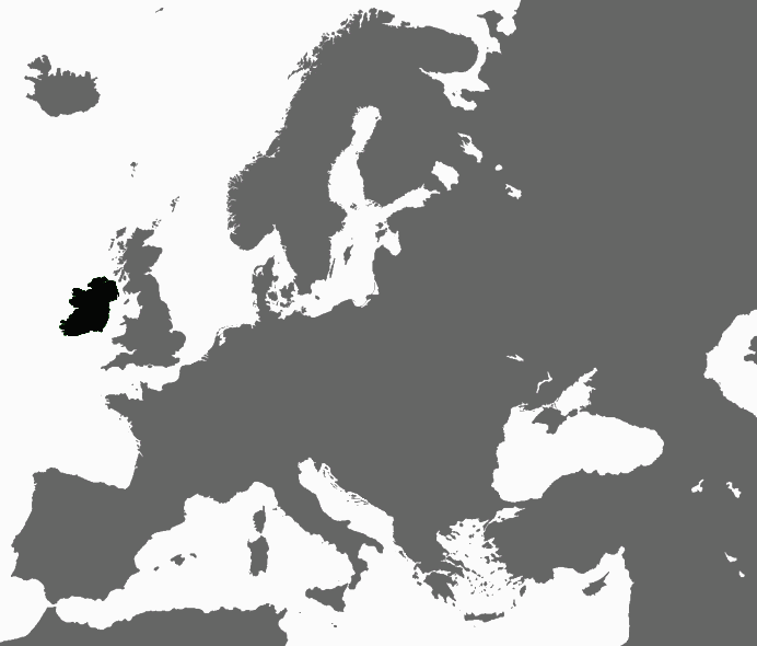
Ireland (Ulster-Scots: Airlann or Airlan) is an island to the north-west of continental Europe. It is the third-largest island in Europe and the twentieth-largest island on Earth. To its east is the larger island of Great Britain, from which it is separated by the Irish Sea.
Politically, Ireland is divided between the Republic of Ireland, which covers just under five-sixths of the island, and Northern Ireland, a part of the United Kingdom, which covers the remainder and is located in the north-east of the island. The population of Ireland is approximately 6.4 million. Just under 4.6 million live in the Republic of Ireland and just under 1.8 million live in Northern Ireland.
The island's geography comprises relatively low-lying mountains surrounding a central plain, with several navigable rivers extending inland. The island has lush vegetation, a product of its mild but changeable oceanic climate, which avoids extremes in temperature. Thick woodlands covered the island until the 17th century. Today, it is one of the most deforested areas in Europe. There are twenty-six extant mammal species native to Ireland.
A Norman invasion in the Middle Ages gave way to a Gaelic resurgence in the 13th century. Over sixty years of intermittent warfare in the 1500s led to English dominance after 1603. In the 1690s, a system of Protestant English rule was designed to materially disadvantage the Catholic majority and Protestant dissenters, and was extended during the 18th century. In 1801, Ireland became a part of the United Kingdom. A war of independence in the early 20th century led to the partition of the island, creating the Irish Free State, which became increasingly sovereign over the following decades. Northern Ireland remained a part of the United Kingdom and saw much civil unrest from the late 1960s until the 1990s. This subsided following a political agreement in 1998. In 1973, both parts of Ireland joined the European Economic Community.
Irish culture has had a significant influence on other cultures, particularly in the fields of literature and, to a lesser degree, science and education. A strong indigenous culture exists, as expressed for example through Gaelic games, Irish music and the Irish language, alongside mainstream Western culture, such as contemporary music and drama, and a culture with much in common with Great Britain, as expressed through sports such as soccer, rugby, horse racing, and golf, as well as the English language.
PRE-HISTORY
Most of Ireland was covered with ice until the end of the last ice age over 9,000 years ago. Sea levels were lower and Ireland, like Great Britain, was part of continental Europe. Mesolithic stone age inhabitants arrived some time after 8,000 BC and agriculture followed with the Neolithic Age around 4,500 to 4,000 BC.
At the Céide Fields, preserved beneath a blanket of peat in present-day County Mayo, is an extensive field system, arguably the oldest in the world, dating from not long after this period. Consisting of small divisions separated by dry-stone walls, the fields were farmed for several centuries between 3,500 and 3,000 BC. Wheat and barley were the principal crops.
The Bronze Age – defined by the use of metal – began around 2,500 BC, with technology changing people's everyday lives during this period through innovations such as the wheel, harnessing oxen, weaving textiles, brewing alcohol, and skillful metalworking, which produced new weapons and tools, along with fine gold decoration and jewellery, such as brooches and torcs. According to John T. Koch and others, Ireland in the Late Bronze Age was part of a maritime trading-networked culture called the Atlantic Bronze Age that also included Britain, France, Spain and Portugal where Celtic languages developed.
The Iron Age in Ireland is traditionally associated with people known as the Celts. The Celts were commonly thought to have colonised Ireland in a series of invasions between the 8th and 1st centuries BC. The Gaels, the last wave of Celts, were said to have divided the island into five or more kingdoms after conquering it. However, some academics favour a theory that emphasises the diffusion of culture from overseas as opposed to a military colonisation. Finds such as Clonycavan Man are given as evidence for this theory.
LATE
ANTIQUITY and MEDIEVAL TIMES
The earliest written records of Ireland come from classical Greco-Roman geographers. Ptolemy in his Almagest refers to Ireland as Mikra Brettania (Little Britain), in contrast to the larger island, which he called Megale Brettania (Great Britain). In his later work, Geography, Ptolemy refers to Ireland as Iouernia and to Great Britain as Albion. These "new" names were likely to have been the Celtic names for the islands at the time. The earlier names, in contrast, were likely to have been coined before direct contact with local peoples was made.
The Romans would later refer to Ireland by this name too in its Latinised form, Hibernia, or Scotia. Ptolemy records sixteen tribes inhabiting every part of Ireland in 100 AD. The relationship between the Roman Empire and the tribes of ancient Ireland is unclear. However, a number of finds of Roman coins have been found, for example at Newgrange.
Ireland continued as a patchwork of rival tribes but, beginning in the 7th century AD, a concept of national kingship gradually became articulated through the concept of a High King of Ireland. Medieval Irish literature portrays an almost unbroken sequence of High Kings stretching back thousands of years but modern historians believe the scheme was constructed in the 8th century to justify the status of powerful political groupings by projecting the origins of their rule into the remote past.
The High King was said to preside over the patchwork of provincial kingdoms that together formed Ireland. All of these kingdoms had their own kings but were at least nominally subject to the High King. The High King was drawn from the ranks of the provincial kings and ruled also the royal kingdom of Meath, with a ceremonial capital at the Hill of Tara. The concept only became a political reality in the Viking Age and even then was not a consistent one. However, Ireland did have a unifying rule of law: the early written judicial system, the Brehon Laws, administered by a professional class of jurists known as the brehons.
The Chronicle of Ireland records that in 431 AD Bishop Palladius arrived in Ireland on a mission from Pope Celestine I to minister to the Irish "already believing in Christ." The same chronicle records that Saint Patrick, Ireland's best known patron saint, arrived the following year. There is continued debate over the missions of Palladius and Patrick but the consensus is that they both took place and that the older druid tradition collapsed in the face of the new religion.
Irish Christian scholars excelled in the study of Latin and Greek learning and Christian theology. In the monastic culture that followed the Christianisation of Ireland, Latin and Greek learning was preserved in Ireland during the Early Middle Ages in contrast to elsewhere in Europe, where the Dark Ages followed the decline of the Roman Empire.
The arts of manuscript illumination, metalworking and sculpture flourished and produced treasures such as the Book of Kells, ornate jewellery and the many carved stone crosses that still dot the island today. A mission founded in 563 on Iona by the Irish monk Saint Columba began a tradition of Irish missionary work that spread Christianity and learning to Scotland, England and the Frankish Empire on Continental Europe after the fall of Rome. These missions continued until the late Middle Ages, establishing monasteries and centres of learning, producing scholars such as Sedulius Scottus and Johannes Eriugena and exerting much influence in Europe.
From the 9th century, waves of Viking raiders plundered Irish monasteries and towns. These raids added to a pattern of raiding and endemic warfare that was already deep-seated in Ireland. The Vikings also were involved in establishing most of the major coastal settlements in Ireland: Dublin, Limerick, Cork, Wexford, Waterford, and also Carlingford, Strangford, Annagassan, Arklow, Youghal, Lough Foyle and Lough Ree.
NORMAN and ENGLISH INVASION
On May 1, 1169, an expedition of Cambro-Norman knights with an army of about six hundred landed at Bannow Strand in present-day County Wexford. It was led by Richard de Clare, called Strongbow due to his prowess as an archer. The invasion, which coincided with a period of renewed Norman expansion, was at the invitation of Dermot Mac Murrough, the king of Leinster.
In 1166, Mac Murrough had fled to Anjou, France following a war involving Tighearnán Ua Ruairc, of Breifne, and sought the assistance of the Angevin king, Henry II, in recapturing his kingdom. In 1171, Henry arrived in Ireland in order to review the general progress of the expedition. He wanted to re-exert royal authority over the invasion which was expanding beyond his control. Henry successfully re-imposed his authority over Strongbow and the Cambro-Norman warlords and persuaded many of the Irish kings to accept him as their overlord, an arrangement confirmed in the 1175 Treaty of Windsor.
The invasion was legitimised by the provisions of the Papal Bull Laudabiliter, issued by Adrian IV in 1155. The bull encouraged Henry to take control in Ireland in order to oversee the financial and administrative reorganisation of the Irish Church and its integration into the Roman Church system. Some restructuring had already begun at the ecclesiastical level following the Synod of Kells in 1152. There has been significant controversy regarding authenticity of Laudabiliter,and there is no general agreement as to whether the bull was genuine or a forgery.
In 1172, the new pope, Alexander III, further encouraged Henry to advance the integration of the Irish Church with Rome. Henry was authorised to impose a tithe of one penny per hearth as an annual contribution. This church levy, called Peter's Pence, is still extant in Ireland as a voluntary donation. In turn, Henry accepted the title of Lord of Ireland which Henry conferred on his younger son, John Lackland, in 1185. This defined the Irish state as the Lordship of Ireland. When Henry's successor died unexpectedly in 1199, John inherited the crown of England and retained the Lordship of Ireland.
Over the century that followed, Norman feudal law gradually replaced the Gaelic Brehon Law so that by the late 13th century the Norman-Irish had established a feudal system throughout much of Ireland. Norman settlements were characterised by the establishment of baronies, manors, towns and the seeds of the modern county system. A version of the Magna Carta (the Great Charter of Ireland), substituting Dublin for London and Irish Church for Church of England, was published in 1216 and the Parliament of Ireland was founded in 1297.
From the mid-14th century, after the Black Death, Norman settlements in Ireland went into a period of decline. The Norman rulers and the Gaelic Irish elites intermarried and the areas under Norman rule became Gaelicised. In some parts, a hybrid Hiberno-Norman culture emerged. In response, the Irish parliament passed the Statutes of Kilkenny in 1367. These were a set of laws designed to prevent the assimilation of the Normans into Irish society by requiring English subjects in Ireland to speak English, follow English customs and abide by English law. However, by the end of the 15th century central English authority in Ireland had all but disappeared and a renewed Irish culture and language, albeit with Norman influences, was dominant again. English Crown control remained relatively unshaken in an amorphous foothold around Dublin known as The Pale and under the provisions of Poynings' Law of 1494, the Irish Parliamentary legislation was subject to the approval of the English Parliament.
KINGDOM of IRELAND
The title of King of Ireland was re-created in 1542 by Henry VIII, then King of England, of the Tudor dynasty. English rule of law was reinforced and expanded in Ireland during the latter part of the 16th century leading to the Tudor conquest of Ireland. A near complete conquest was achieved by the turn of the 17th century, following the Nine Years' War and the Flight of the Earls. This control was further consolidated during the wars and conflicts of the 17th century, which witnessed English and Scottish colonisation in the Plantations of Ireland, the Wars of the Three Kingdoms and the Williamite War. Irish losses during the Wars of the three Kingdoms (which, in Ireland, included the Irish Confederacy and the Cromwellian conquest of Ireland) are estimated to include 20,000 battlefield casualties. 200,000 civilians are estimated to have died as a result of a combination of war-related famine, displacement, guerilla activity and pestilence over the duration of the war. A further 50,000 were sent to slavery in the West Indies. Some historians estimate that as much as half of the pre-war population of Ireland may have died as a result of the conflict.
The religious struggles of the 17th century left a deep sectarian division in Ireland. Religious allegiance now determined the perception in law of loyalty to the Irish King and Parliament. After the passing of the Test Act 1672, and with the victory of the forces of the dual monarchy of William and Mary over the Jacobites, Roman Catholics and nonconforming Protestant Dissenters were barred from sitting as members in the Irish Parliament. Under the emerging penal laws Irish Roman Catholics and Dissenters were increasingly deprived of various and sundry civil rights even to the ownership of hereditary property. Additional regressive punitive legislation followed 1703, 1709 and 1728. This completed a comprehensive systemic effort to materially disadvantage Roman Catholics and Protestant Dissenters, while enriching a new ruling class of Anglican conformists. The new Anglo-Irish ruling class became known as the Protestant Ascendancy.
An extraordinary climatic shock known as the "Great Frost" struck Ireland and the rest of Europe between December 1739 and September 1741, after a decade of relatively mild winters. The winters destroyed stored crops of potatoes and other staples and the poor summers severely damaged harvests. This resulted in the famine of 1740. An estimated 250,000 people (about one in eight of the population) died from the ensuing pestilence and disease. The Irish government halted export of corn and kept the army in quarters but did little more. Local gentry and charitable organisations provided relief but could do little to prevent the ensuing mortality.
In the aftermath of the famine, an increase in industrial production and a surge in trade brought a succession of construction booms. The population soared in the latter part of this century and the architectural legacy of Georgian Ireland was built. In 1782, Poynings' Law was repealed, giving Ireland legislative independence from Great Britain for the first time since 1495. The British government, however, still retained the right to nominate the government of Ireland without the consent of the Irish parliament.
In 1798, members of the Protestant Dissenter tradition (mainly Presbyterian) made common cause with Roman Catholics in a republican rebellion inspired and led by the Society of United Irishmen, with the aim of creating an independent Ireland. Despite assistance from France the rebellion was put down by British and Irish government and yeomanry forces. In 1800, the British and Irish parliaments both passed Acts of Union that, with effect from 1 January 1801, merged the Kingdom of Ireland and the Kingdom of Great Britain to create a United Kingdom of Great Britain and Ireland.
UNION with GREAT BRITAIN
The passage of the Act in the Irish Parliament was ultimately achieved with substantial majorities, having failed on the first attempt in 1799. According to contemporary documents and historical analysis, this was achieved through a considerable degree of bribery, with funding provided by the British Secret Service Office, and the awarding of peerages, places and honours to secure votes. Thus, Ireland became part of an extended United Kingdom, ruled directly by a united parliament at Westminster in London.
Aside from the development of the linen industry, Ireland was largely passed over by the industrial revolution, partly because it lacked coal and iron resources and partly because of the impact of the sudden union with the structurally superior economy of England, which saw Ireland as a source of agricultural produce and capital.
The Great Famine of the 1840s caused the deaths of one million Irish people and over a million more emigrated to escape it. By the end of the decade, half of all immigration to the United States was from Ireland. The period of civil unrest that followed until the end of the 19th century is referred to as the Land War. Mass emigration became deeply entrenched and the population continued to decline until the mid-20th century. Immediately prior to the famine the population was recorded as 8.2 million by the 1841 census. The population has never returned to this level since. The population continued to fall until 1961 and it was not until the 2006 census that the last county of Ireland (County Leitrim) to record a rise in population since 1841 did so.
The 19th and early 20th centuries saw the rise of modern Irish nationalism, primarily among the Roman Catholic population. The pre-eminent Irish political figure after the Union was Daniel O'Connell. He was elected as Member of Parliament for Ennis in a surprise result and despite being unable to take his seat as a Roman Catholic. O'Connell spearheaded a vigorous campaign that was taken up by the Prime Minister, the Irish-born soldier and statesman, the Duke of Wellington. Steering the Catholic Relief Bill through Parliament, aided by future prime minister Robert Peel, Wellington prevailed upon a reluctant George IV to sign the Bill and proclaim it into law. George's father had opposed the plan of the earlier Prime Minister, Pitt the Younger, to introduce such a bill following the Union of 1801, fearing Catholic Emancipation to be in conflict with the Act of Settlement 1701.
A subsequent campaign, led by O'Connell, for the repeal of the Act of Union failed. Later in the century, Charles Stewart Parnell and others campaigned for autonomy within the Union, or "Home Rule". Unionists, especially those located in Ulster, were strongly opposed to Home Rule, which they thought would be dominated by Catholic interests. After several attempts to pass a Home Rule bill through parliament, it looked certain that one would finally pass in 1914. To prevent this from happening, the Ulster Volunteers were formed in 1913 under the leadership of Edward Carson.
Their formation was followed in 1914 by the establishment of the Irish Volunteers, whose aim was to ensure that the Home Rule Bill was passed. The Act was passed but with the "temporary" exclusion of the six counties of Ulster that would become Northern Ireland. Before it could be implemented, however, the Act was suspended for the duration of the First World War. The Irish Volunteers split into two groups. The majority, approximately 175,000 in number, under John Redmond, took the name National Volunteers and supported Irish involvement in the war. A minority, approximately 13,000, retained the Irish Volunteers' name, and opposed Ireland's involvement in the war.
The failed Easter Rising of 1916 was carried out by the latter group in alliance with a smaller socialist militia, the Irish Citizen Army. The British response, executing fifteen leaders of the Rising over a period of ten days and imprisoning or interning more than a thousand people, turned the mood of the country in favour of the rebels. Support for Irish republicanism increased further due to the ongoing war in Europe, as well as the Conscription Crisis of 1918. The pro-independence republican party, Sinn Féin, received overwhelming endorsement in the general election of 1918, and in 1919 proclaimed an Irish Republic, setting up its own parliament (Dáil Éireann) and government. Simultaneously the Volunteers, which became known as the Irish Republican Army (IRA), launched a three-year guerilla war, which ended in a truce in July 1921 (although violence continued until June 1922, mostly in Northern Ireland).
In December 1921, the Anglo-Irish Treaty was concluded between the British Government and representatives of the Second Dáil. It gave Ireland complete independence in its home affairs and practical independence for foreign policy, but an opt-out clause allowed Northern Ireland to remain within the United Kingdom, which it immediately exercised as expected. Additionally, an oath of allegiance to the King was to be taken. Disagreements over these provisions led to a split in the nationalist movement and a subsequent civil war between the new government of the Irish Free State and those opposed to the treaty, led by Éamon de Valera. The civil war officially ended in May 1923 when de Valera issued a cease-fire order.
PARTITION - INDEPENDENT IRELAND
During its first decade the newly formed Irish Free State was governed by the victors of the civil war. When de Valera achieved power, he took advantage of the Statute of Westminster and political circumstances to build upon inroads to greater sovereignty made by the previous government. The oath was abolished and in 1937 a new constitution was adopted. This completed a process of gradual separation from the British Empire that governments had pursued since independence. However, it was not until 1949 that the state was declared, officially, to be the Republic of Ireland.
The state was neutral during World War II, but offered clandestine assistance to the Allies, particularly in the potential defence of Northern Ireland. Despite being neutral, approximately
50,000 volunteers from independent Ireland joined the British forces during the war, four being awarded Victoria Crosses.
German Intelligence was also active in Ireland, with both the Abwehr (German for Defence; the German military intelligence service) and the SD (the Sicherheitsdienst, English: Security Service, the intelligence service of the SS) sending agents
there. German intelligence operations effectively ended in September 1941 when police made arrests on the basis of surveillance carried out on the key diplomatic legations in Ireland, including that of the United States. To the authorities counterintelligence was a fundamental line of defence. With a regular army of only slightly over seven thousand men at the start of the war, and with limited supplies of modern weapons, the state would have had great difficulty in defending itself from invasion from either side of the conflict.
Large-scale emigration marked the 1950s and 1980s, but beginning in 1987 the economy improved, and the 1990s saw the beginning of substantial economic growth. This period of growth became known as the Celtic Tiger. The Republic's real GDP grew by an average of 9.6% per annum between 1995 and 1999, in which year the Republic joined the euro. In 2000 Ireland was the sixth-richest country in the world in terms of GDP per capita. Social changes followed quickly on the heels of economic prosperity, ranging from the 'modernisation' of the annual parade in Dublin to mark the principal national holiday of Saint Patrick's Day (17 March), to the decline in authority of the Catholic Church. The financial crisis of 2008–2010 dramatically ended this period of boom. GDP fell by 3% in 2008 and by 7.1% in 2009, the worst year since records began (although earnings by foreign-owned businesses continued to grow). The state has since experienced deep recession, with unemployment, which doubled during 2009, remaining above 14% in 2012.
NORTHERN IRELAND
Northern Ireland was created as a division of the United Kingdom by the Government of Ireland Act 1920 and until 1972 it was a self-governing jurisdiction within the United Kingdom with its own parliament and prime minister. Northern Ireland, as part of the United Kingdom, was not neutral during the Second World War and Belfast suffered four bombing raids in 1941. Conscription was not extended to Northern Ireland and roughly an equal number volunteered from Northern Ireland as volunteered from the south. One, James Joseph Magennis, received the
Victoria Cross for valour.
Although Northern Ireland was largely spared the strife of the civil war, in decades that followed partition there were sporadic episodes of inter-communal violence. Nationalists, mainly Roman Catholic, wanted to unite Ireland as an independent republic, whereas unionists, mainly Protestant, wanted Northern Ireland to remain in the United Kingdom. The Protestant and Catholic communities in Northern Ireland voted largely along sectarian lines, meaning that the Government of Northern Ireland (elected by "first-past-the-post" from 1929) was controlled by the Ulster Unionist Party. Over time, the minority Catholic community felt increasingly alienated with further disaffection fueled by practices such as gerrymandering and discrimination in housing and employment.
In the late 1960s, nationalist grievances were aired publicly in mass civil rights protests, which were often confronted by loyalist counter-protests. The government's reaction to confrontations was seen to be one-sided and heavy-handed in favour of unionists. Law and order broke down as unrest and inter-communal violence increased. The Northern Ireland government requested the British Army to aid the police, who were exhausted after several nights of serious rioting. In 1969, the paramilitary Provisional IRA, which favoured the creation of a united Ireland, emerged from a split in the Irish Republican Army and began a campaign against what it called the "British occupation of the six counties".
Other groups, on both the unionist side and the nationalist side, participated in violence and a period known as the Troubles began. Over 3,600 deaths resulted over the subsequent three decades of conflict. Owing to the civil unrest during the Troubles, the British government suspended home rule in 1972 and imposed direct rule. There were several unsuccessful attempts to end the Troubles politically, such as the Sunningdale Agreement of 1973. In 1998, following a ceasefire by the Provisional IRA and multi-party talks, the Good Friday Agreement was concluded as a treaty between the British and Irish governments, annexing the text agreed in the multi-party talks. The substance of the Agreement (formally referred to as the Belfast Agreement) was later endorsed by referendums in both parts of Ireland. The Agreement restored self-government to Northern Ireland on the basis of power-sharing in a regional Executive drawn from the major parties in a new Northern Ireland Assembly, with entrenched protections for the two main communities. The Executive is jointly headed by a First Minister and deputy First Minister drawn from the unionist and nationalist parties. Violence had decreased greatly after the Provisional IRA and loyalist ceasefires in 1994 and in 2005 the Provisional IRA announced the end of its armed campaign and an independent commission supervised its disarmament and that of other nationalist and unionist paramilitary
organisations. The Assembly and power-sharing Executive were suspended several times but were restored again in 2007. In that year the British government officially ended its military support of the police in Northern Ireland (Operation Banner) and began withdrawing troops. On Wednesday, 27 June 2012, Northern Ireland's deputy first minister and former IRA commander, Martin McGuinness, shook hands with
Queen Elizabeth II in Belfast, a handshake symbolizing reconciliation between the two nations.
GEOGRAPHY
The island of Ireland is located in the north-west of Europe, between latitudes 51° and 56° N, and longitudes 11° and 5° W. It is separated from the neighbouring island of Great Britain by the Irish Sea and the North Channel, which has a width of 23 kilometres (14 mi)at its narrowest point. To the west is the northern Atlantic Ocean and to the south is the Celtic Sea, which lies between Ireland and Brittany, in France. Ireland and Great Britain, together with nearby islands, are known collectively as the British Isles. As the term British Isles is controversial in relation to Ireland, the alternate term Britain and Ireland is often used as a neutral term for the islands.
A ring of coastal mountains surround low plains at the centre of the island. The highest of these is Carrauntoohil (Irish: Corrán Tuathail) in County Kerry, which rises to 1,038 m (3,406 ft) above sea level. The most arable land lies in the province of Leinster. Western areas can be mountainous and rocky with green panoramic vistas. The River Shannon, the island's longest river at 386 km (240 mi) long, rises in County Cavan in the north west and flows 113 kilometres (70 mi) to Limerick city in the mid west.
The island's lush vegetation, a product of its mild climate and frequent rainfall, earns it the sobriquet the Emerald Isle. Overall, Ireland has a mild but changeable oceanic climate with few extremes. The climate is typically insular and is temperate avoiding the extremes in temperature of many other areas in the world at similar latitudes. This is a result of the moderating moist winds which ordinarily prevail from the South-Western Atlantic.
Precipitation falls throughout the year but is light overall, particularly in the east. The west tends to be wetter on average and prone to Atlantic storms, especially in the late autumn and winter months. These occasionally bring destructive winds and higher total rainfall to these areas, as well as sometimes snow and hail. The regions of north County Galway and east County Mayo have the highest incidents of recorded lightning annually for the island, with lightning occurring approximately five to ten days per year in these areas. Munster, in the south, records the least snow whereas Ulster, in the north, records the most.
Inland areas are warmer in summer and colder in winter. Usually around 40 days of the year are below freezing 0 °C (32 °F) at inland weather stations, compared to 10 days at coastal stations. Ireland is sometimes affected by heat waves, most recently in 1995, 2003 and 2006. In common with the rest of Europe, Ireland experienced unusually cold weather during the winter of 2009/10. Temperatures fell as low as −17.2 °C (1 °F) in County Mayo on December 20 and up to a metre (3 ft) of snow in mountainous areas.
The island consists of varied geological provinces. In the far west, around County Galway and County Donegal, is a medium to high grade metamorphic and igneous complex of Caledonide affinity, similar to the Scottish Highlands. Across southeast Ulster and extending southwest to Longford and south to Navan is a province of Ordovician and Silurian rocks, with similarities to the Southern Uplands province of Scotland. Further south, along the County Wexford coastline, is an area of granite intrusives into more Ordovician and Silurian rocks, like that found in Wales. In the southwest, around Bantry Bay and the mountains of Macgillicuddy's Reeks, is an area of substantially deformed, but only lightly metamorphosed, Devonian-aged rocks. This partial ring of "hard rock" geology is covered by a blanket of Carboniferous limestone over the centre of the country, giving rise to a comparatively fertile and lush landscape. The west-coast district of the Burren around Lisdoonvarna has well-developed karst features. Significant stratiform lead-zinc mineralisation is found in the limestones around Silvermines and Tynagh.
Hydrocarbon exploration is ongoing following the first major find at the Kinsale Head gas field off Cork in the mid-1970s. More recently, in 1999, economically significant finds of natural gas were made in the Corrib Gas Field off the County Mayo coast. This has increased activity off the west coast in parallel with the "West of Shetland" step-out development from the North Sea hydrocarbon province. The Helvick oil field, estimated to contain over 28 million barrels (4,500,000 m3) of oil, is another recent discovery.
NAVIGATION
MONA
LISA 2
MonaLisa
2 is a Swedish led project concentrating on Sea Traffic Management with
increased focus on the safe navigation of
large passenger vessels, after the Costa
Concordia and Baltic
Ace accidents in
January and December 2012. MonaLisa 2 is a continuation of the MonaLisa 1
project, the partners for which are as follows:-
The Danish
Maritime Authority has
responsibility for the construction, equipment and operation of Danish
ships including safety, navigational regulations, ship registration,
shipping policy, maritime law as well as industrial policy, both
nationally and internationally. The DMA is a government agency part
of the Ministry of Business.
The Finnish
Transport Agency The
Finnish Transport Agency is responsible for the traffic management on
roads, waterways and railways. The Finnish Transport Agency’s
Hydrographic Office publishes printed and electronic charts of Finland’s
coastal and lake areas and manages the ongoing chart update service.
GateHouse is
specialises in the development of technical software and system
integration for advanced satellite communications and tracking systems.
They are a leading independent provider of complete embedded software for Inmarsat BGAN
terminals
SAAB serves
the global market: governments (navy), coastguards and corporations with
products, services and solutions from military defence to civil navigation
via LPI pulsed radar, sonar and
other transponders.
SSPA provide
effective marine transport solutions for the maritime field – ship
design, maritime operations, port development and coastal services.
Seventy percent of the earth’s surface
is water, with 90 percent of cargo transported by ships. SSPA is aware
that the maritime industry has tremendous impact on our environment.
The Swedish
Maritime Administration (SMA)
offers modern and safe shipping routes with 24 hour service. SMA is a
governmental agency and enterprise within the transport sector and is
responsible for maritime safety and the future of shipping, primarily
merchant shipping, but also pleasure boating and fishing. Services
include: Port Pilots and Marine Traffic Information.
The University
of Chalmers is a
highly progressive, situated in Gothenburg. They are known globally for
education, research and innovation.
EfficienSea is
concerned with the development of safe sustainable traffic at sea - in
particular the e-Navigation: "the harmonized creation,
collection, integration, exchange and presentation of maritime information
on board and ashore by electronic means to enhance berth-to-berth
navigation and related services, for safety and security at sea and
protection of the marine environment." Ref: Committee of the
International Association of Marine Aids to Navigation and Lighthouse
Authorities, IALA.
MONA
LISA CONTACTS
Magnus
Sundström
MONALISA Project Leader
Swedish
Maritime Administration
Market Department
Phone: +46 10 47 84 681
E-mail: magnus.sundstrom@sjofartsverket.se
http://www.sjofartsverket.se/en/MonaLisa/
MUNIN
The
MUNIN project (Maritime Unmanned Navigation through Intelligence in
Networks) is a collaborative research project, co-funded by the European
Commission under its
Seventh Framework Programme.
The
MUNIN project is to develop and verify a concept for an autonomous
ship, which they define as a vessel primarily guided by automated
on-board decision system. The onboard system is finally controlled by a
remote operator in a shore side control station. The concept therefore
runs parallel to the thinking of the SolarNavigator team - provided only
that the levels of autonomy may vary - clearly, a solar powered
ship is that much more self reliant.
MUNIN
PARTNERS
The
Fraunhofer Center for Maritime Logistics and Services CML (Fraunhofer CML)
is situated at the Hamburg University of Technology in Hamburg, Germany. Fraunhofer
CML homepage Hans-Christoph
Burmeister, is the project coordinator at Fraunhofer CML
The
Norwegian Marine Technology Research Institute (MARINTEK), Trondheim,
Norway. MARINTEK is a company in the SINTEF Group, one of Europe’s
largest independent research institutions. MARINTEK
homepage
Chalmers
University of Technology is a Swedish university
located in Gothenburg that focuses on research and education in
technology, natural science, and architecture. Chalmers
homepage
Hochschule
Wismar – University of Applied Sciences Technology: Department of
Maritime Studies is part of the faculty of Engineering at Hochschule
Wismar, situated in Rostock-Warnemünde, Germany. They are exerts in
simulator training as full mission ship handling carried out by Professors
and lecturers with license management levels such as Master of a ship or
Chief Engine Officer. Hochschule
Wismar homepage
Aptomar
AS is a Norwegian company located in Trondheim specialising in marine
sensor systems such as the SECurus system that combines advanced
stabilized long range IR and digital video cameras with an Electronic
Chart System which overlays information of several sources for a speedy
evaluation of real time situations for good response. Aptomar
AS homepage
MarineSoft
Entwicklungs- und Logistikgesellschaft mbH is an internationally operating
provider for maritime software solutions, located in Rostock-Warnemünde,
Germany. It offers state-of-the-art solutions in the field of maritime
simulation of machinery plants, computer based training applications,
information and operation systems, consultancy and courseware. MarineSoft
homepage
Marorka
ehf is a leading provider of energy management solutions for the
international shipping industry with it’s headquarters in Reykjavik, Iceland.
Marorka’s products and services enable vessel operators to optimize fuel
consumption by maximizing the energy efficiency of their vessel or fleet. Marorka
ehf homepage
University
College Cork UCC is situated in south-west Ireland and
was founded as a Queen’s College in 1845. The Law Department at UCC is
at the forefront of legal research in Ireland, the EU and internationally
in various areas, including environmental law, human rights, marine law,
business law, comparative law, constitutional law and legal theory. UCC
homepage
MUNIN
CONTACTS
Project
Manager - Hans-Christoph
Burmeister
Fraunhofer
Center for Maritime Logistics and Services CML
Schwarzenbergstraße 95 D
21073 Hamburg, Germany
Phone: +49 (0)40 42878-6131
Fax: +49 (0)40 42878-4452
Ørnulf
Jan Rødseth
MARINTEK
Dep. Maritime Transport Systems
Otto Nielsens veg 10
Trondheim, Norway
Phone: +47 7359 5257
info@unmanned-ship.org
|
Adelaide
Aden
- Yemen
Afghanistan
Africa
Alaska
Albania
Algeria
Amazon
Rainforest
Amsterdam
Antarctic
Arctic
North Pole
Argentina
Asia
Athens
Atlantis
- Plato's Lost City
Australia
Austria
Aztecs
- Mexico
Baghdad
Bahamas
Bahrain
Bangladesh
Barbados
Beachy
Head, England
Belgium
Benin
Berlin
Bermuda
Black
Rock Desert
Bohemia
Bolivia Bonneville
Utah History
Bonneville,
Utah, USA
Brazil
Brighton
- West Pier
British
Columbia
Buckingham
Palace
Bulgaria
Burkina
Faso
Burma
California
Canada
Canary
Islands
Cape
Horn
Cape
Verde
Cape
York - Au
Caribbean
Cayman
Islands
Central
Africa
Chichester
Harbour
Chile
China
Columbo
- Sri Lanka
Columbia
Corfu
Cowes,
Isle of Wight
Croatia
Crooked
Island, Bahamas
Cuba
Cyprus
Czechoslovakia
Darwin
- Australia
Daytona
Beach
Denmark
Eastbounre
Pier, England
Earthquakes
Ecuador
Egypt
Eindhoven Estonia
Equator
Europe
Falkland
Islands
Falmouth,
Cornwall
Fiji
Finland
France
Galapagos
Islands
Geography
Links
Geography
Mountains
Geography
Records
Geography
Resources
Geography
Statistics
|
Germany
Ghana
Gibraltar
- Links
Greece
Greenland
Guinea
Guinea
Bissau
Hawaii
Holland
the Nertherlands
Hollywood,
California, LA
Hong
Kong
Hungary
Hurricanes
Iceland
India
Indonesia
Links
Iran
Iraq
Ireland
Isle
of Man
Isle
of Wight
- The
Needles
Israel
Italy
Ivory
Coast
Jakarta
- Java
Japan
Johannesburg
Jordan
Kent,
England
Kenya
Korea
Kuwait
Kyoto
Lanzarote,
Gran Canaria
Las
Vegas
Lebanon
Liberia
Libya
Liechtenstein
Life
on Earth
Lithuania
London
- Big
Ben
London
Eye
London
Houses
Parliament
London
- Buckingham
Palace
London
- Old
Bailey
London
- Overview
London
- The City
London
- Tower Bridge
London
- Trafalgar
Square
Luxembourg
Madame
Tussauds
Malaysia
Mali
Malta
Marshal
Islands
Mauritania
Maya
Empire -
Central America
Melbourne,
Australia
Middle
East
Melbourne,
Australia
Mexico
Monaco
Morocco
Mountains
Mumbai
Naples-
Italy
National
Geographic
Nepal
New
York
New
Zealand
Niger
Nigeria
North
Africa
Norway
Nova
Scotia
Oceans
and Seas
Oman
Pakistan
Palermo
- Sicily
Palestine
Palma
- Malorca
|
Panama
Canal - Links
Paris
Pendine
Sands
Peru
Philippines
Pisa,
Leaning Tower
Planet
Earth
Poland
Port
Moresby - PNG
Port
Said - Egypt
Portugal
Puerto
Rico
Qatar
Quebec
Rio
de Janeiro
Romania
Rome
Russia
Salt
Lake City
Samoa
Saudi
Arabia
Scandanavia
Scotland
Senegal
Siera
Leone
Singapore
Solomon
Islands
Somalia
South
Africa
South
America
Southampton
Spain
- Espana
Sri
Lanka - Links
Stonehenge
Sudan
Suez
Canal
Sundancer
Holiday Resort
Sussex,
England Index
Sweden
Switzerland
Sydney,
Australia
Syria
Tahiti
- Polynesia
- Links
Tahitian
- Men & Women Customs
Taiwan
Thailand
The
Gambia
Togo
Tokyo,
Japan
Tonga
- Polynesia
Toronto
Trinidad
- Lesser Antilles
Trinidad
and Tobago
Tsunami
Tunbridge
Wells, England
Tunisia
Turkey
Tuvalu
Islands
UAE
- United Arab Emirates
UK
Statistics
Ukraine
United
Kingdom
United
Kingdom -
Gov
USA
Uruguay
Vanuatu
Islands
Vatican
City
Venezuela
Venice
Vienna
Vietnam
Volcanoes
Volendam
Wales
Washington
D.C.
WAYN
Where Are You Now
Wealden
iron industry
Wendover
West
Africa
World
Peace Supporters
Yemen
Yugoslavia
Zurich
|

Solar
Cola drinkers care about planet
earth
..
Thirst for Life

(330ml
Planet Earth can)
|