|
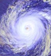
A
hurricane is a severe tropical storm, that forms
in the southern Atlantic Ocean, Caribbean Sea,
Gulf of Mexico or in the eastern Pacific Ocean.
Hurricanes need warm tropical oceans, moisture
and light winds above them. If the right
conditions last long enough, a hurricane can
produce violent winds, incredible waves,
torrential rains and floods.
Hurricanes
rotate in a counterclockwise direction around an
"eye." Hurricanes have winds at least
74 miles per hour. There are on average six
Atlantic hurricanes each year; over a 3-year
period, approximately five hurricanes strike the
United States coastline from Texas to Maine.
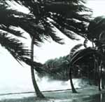
When
hurricanes move onto land, the heavy rain,
strong winds and heavy waves can damage
buildings, trees and cars. The heavy waves are
called a storm surge. Storm surge is very
dangerous and a major reason why you MUST stay
away from the ocean during a hurricane warning
or hurricane.
Basic
Hurricane Safety Actions
•
Know if you live in an evacuation area. Know
your home's vulnerability to storm surge,
flooding and wind. Have a written plan based on
this knowledge.
•
At the beginning of hurricane season (June 1),
check your supplies, replace batteries and use
food stocks on a rotating basis.
•
During hurricane season, monitor the tropics.
Monitor NOAA
Weather Radio.
•
If a storm threatens, heed the advice from local
authorities. Evacuate if ordered.
•
Execute your family plan.
Watch
vs Warning
Know the Difference
A HURRICANE WATCH issued for
your part of the coast indicates the possibility
that you could experience hurricane conditions
within 36 hours. This watch should trigger your
family's disaster plan, and protective measures
should be initiated, especially those actions
that require extra time such as securing a boat,
leaving a barrier island, etc.
A HURRICANE WARNING issued for
your part of the coast indicates that sustained
winds of at least 74 mph are expected within 24
hours or less. Once this warning has been
issued, your family should be in the process of
completing protective actions and deciding the
safest location to be during the storm.
Hurricane
Photos from NOAA's Photo Library
Historic
Weather Service Album -
early satellite imagery, damage photos, graphics
and more...
Hurricane
Hunters in Action - Photos of the
aircraft used in hurricane research.
WEATHER
WATCHES WARNINGS & FORECASTS
NOAA
National Hurricane Center
- maintains a continuous watch on tropical
cyclones over the Atlantic, Caribbean, Gulf of
Mexico and the Eastern Pacific from May 15
through November 30.
NOAA
Central Pacific Hurricane Center
- issues tropical cyclone warnings, watches,
advisories, discussions, and statements for all
tropical cyclones in the Central Pacific from
140 Degrees West Longitude to the International
Dateline.
Naval
Pacific Meteorology and Oceanography Center
Joint Typhoon Warning Center
- Located
at Naval Base Pearl Harbor, Hawaii, the Joint
Typhoon Warning Center (JTWC) is the U.S.
Department of Defense agency responsible for
issuing tropical cyclone warnings for the
Pacific and Indian Oceans.
NOAA
National Weather Service
NOAA
Weather Radio
Satellite
Images of Severe Storm Sectors
- These are NOAA GOES satellite images pointed
over event areas. These sectors change from time
to time.
Satellite
Images of Hurricane Regions
- These images are from NOAA's GOES satellites.
PREPAREDNESS
GUIDES
"Hurricane
Basics" Brochure in PDF
"Hurricane
Basics" (HTML)
Hurricane
and Other Severe Weather Guides from NOAA's
National Hurricane Center
Hurricane
Awareness from NOAA's National Weather Service
Hurricanes...Unleashing
Nature's Fury —
Hurricane
safety and information from the American Red
Cross, NOAA and FEMA (PDF Format)
American
Red Cross — Hurricane Readiness Guide
MORE
INFDRMATION
• The
Saffir-Simpson Hurricane Scale - a
1-5 rating based on the hurricane's present
intensity. This is used to give an estimate of
the potential property damage and flooding
expected along the coast from a hurricane
landfall. Wind speed is the determining factor
in the scale, as storm surge values are highly
dependent on the slope of the continental shelf
in the landfall region.
•
Storm
Names
•
Daily
color satellite images atlantic ocean storms
- You can find links to satellite imagery for
other regions of the world, such as the Eastern
Pacific Ocean.
•
Archived
Satellite Images, Storm Animations and Special
Events - You will find hundreds of
selected satellite images capturing some of the
more important weather and environmental events
over the last 30 years.
• CoastWatch
Products - These are NOAA GOES
satellites images of various coastal sectors.
You can see infrared (IR) or visual (VIS)
versions of these images. Note that the visual
images can only be seen during daylight hours.
• Hurricane
Landfall Experiment 2001 - The 2001
Hurricane Field Program is the fourth year of a
renewed multi-agency effort to unravel the
mysteries of these devastating storms over the
next 5-6 years. This is part of the U.S.
Weather Research Program, which is
focused on reducing the impacts of disastrous
weather on the United States, in particular
hurricane landfall.
• Pronunciation
of Western North Pacific and South China Sea
Cyclones - The Hong Kong Observatory
provides the pronunciations of these storms
through the use of Real Audio.
• Billion
Dollar U.S. Weather Disasters (1980
- 2002)
• NOAA's
"Hurricane Hunter" Aircraft Fly
Through Pacific Winter Storms and More -
NOAA's "hurricane hunter" aircraft and
their crews may be best known for their prowess
in flying through and around nature's severest
storms over the Atlantic Ocean, Caribbean Sea
and Gulf of Mexico. However, these flying
meteorological stations prove their mettle on
the West Coast and over the Pacific Ocean as
well—after hurricane season has ended and
severe Pacific winter storms have begun.
• Converting
UTC or Zulu Time
• Hurricane
Tracking Models
ORGANISATIONS
•
NOAA National
Hurricane Center
- maintains a continuous watch on tropical
cyclones over the Atlantic, Caribbean, Gulf of
Mexico and the Eastern Pacific from May 15
through November 30. The Center prepares and
distributes hurricane watches and warnings for
the general public, and also prepares and
distributes marine and military advisories for
other users. During the "off-season"
NOAA's Hurricane Center provides training for
U.S. emergency managers and representatives from
many other countries that are affected by
tropical cyclones. The Center also conducts
applied research to evaluate and improve
hurricane forecasting techniques, and is
involved in public awareness programs.
•
NOAA
Atlantic Oceanographic and Meteorological
Laboratory - Its mission is to conduct a
basic and applied research program in
oceanography, tropical meteorology, atmospheric
and oceanic chemistry, and acoustics. The
program seeks to understand the physical
characteristics and processes of the ocean and
the atmosphere, both separately and as a coupled
system. The lab is home to the NOAA
Hurricane Research Division.
•
National
Weather Service
•
NOAA
Weather Radio
•
NOAA
National Weather Organization Listing
•
NOAA's
Aircraft Operations Center (Home of NOAA's
Hurricane Hunters) - The
airplanes and helicopters of the Aircraft
Operations Center (AOC) are flown in support of
NOAA's mission to promote global environmental
assessment, prediction and stewardship of the
Earth's environment. NOAA's aircraft operate
throughout the United States and around the
world; over open oceans, mountains, coastal
wetlands, and Arctic pack ice. These versatile
aircraft provide scientists with airborne
platforms necessary to collect the environmental
and geographic data essential to their research.

STORMS
| HURRICANES
| TORNADOES |
ATMOSPHERE
| WATER CYCLE |
FORECASTING
| FLOODS
|
Adelaide
Aden
- Yemen
Africa
Alaska
Amsterdam
Antarctic
Argentina
Athens
Australia
Austria
Aztecs
- Mexico
Bangladesh
Beachy
Head, England
Belgium
Berlin
Bonneville,
Utah, USA
Brazil
Brighton
- West Pier
Canada
Canary
Islands
Cape
York - Au
Cayman
Islands
Chichester
Harbour
China
Columbo
- Sri Lanka
Cowes,
Isle of Wight
Cyprus
Czechoslovakia
Darwin
- Australia
Denmark
Eastbounre
Pier, England
Earthquakes
Egypt
Equator
Europe
Falmouth,
Cornwall
Fiji
Finland
France
Galapagos
Islands
Geography
Links
Geography
Records
Geography
Resources
Geography
Statistics
Germany
Gibraltar
- Links
|
Greece
Greenland
Hawaii
Holland
the Nertherlands
Hollywood,
California, LA
Hong
Kong
Hungary
Hurricanes
Iceland
India
Indonesia
Links
Iran
Iraq
Ireland
Isle
of Man
Isle
of Wight
- The
Needles
Israel
Italy
Jakarta
- Java
Japan
Kent,
England
Korea
Kuwait
Life
on Earth
London
- Big
Ben
London
Eye
London
Houses
Parliament
London
- Buckingham
Palace
London
- Old
Bailey
London
- Overview
London
- The City
London
- Tower Bridge
London
- Trafalgar
Square
Luxembourg
Maya
Empire
- Central America
Melbourne,
Australia
Mexico
Mountains
Naples-
Italy
National
Geographic
New
York
New
Zealand
Norway
Oceans
and Seas
Pakistan
|
Palermo
- Sicily
Palma
- Malorca
Panama
Canal -
Links
Paris
Planet
Earth
Poland
Port
Moresby - PNG
Port
Said - Egypt
Portugal
Rome
Russia
Salt
Lake City - Utah USA
Saudi
Arabia
Scotland
Singapore
South
America
Southampton
Spain
- Espana
Sri
Lanka - Links
Stonehenge
Suez
Canal
Sussex,
England Index
Sweden
Switzerland
Tahiti
- Polynesia
- Links
Taiwan
Tokyo,
Japan
Tonga
- Polynesia
Trinidad
- Lesser Antilles
Tsunami
Tunbridge
Wells, England
Turkey
UAE
- United Arab Emirates
UK
Statistics
Ukraine
United
Kingdom
United
Kingdom
- Gov
USA
Venice
Vienna
Vietnam
Volcanoes
Wales
Washington
D.C.
Wealden
iron industry
World
Peace Supporters
|

Healthier
alternative tastes for adventure capitalists

Solar
Red | Solar
Crush | Solar
Cola | Solar
Spice | Solar
+
|