|
THE EQUATOR
|
||||||||||||||||||||
|
HOME | BIOLOGY | FILMS | GEOGRAPHY | HISTORY | INDEX | MUSIC | THE BOAT | SOLAR BOATS | SPONSORS |
||||||||||||||||||||
|
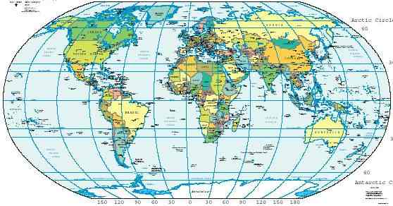
The equator is an imaginary circle drawn around a planet (or other astronomical object) at a distance halfway between the poles. The equator divides the planet into a Northern Hemisphere and a Southern Hemisphere. The latitude of the equator is, by definition, 0°. The length of Earth's equator is about 40,075.0 km, or 24,901.5 miles. The equator is one of the five main circles of latitude based on the relationship of the Earth's rotation and plane of orbit around the sun. Additionally, the equator is the only line of latitude which is also a great circle.
The Sun, in its seasonal movement through the sky, passes directly over the equator twice each year on the Vernal and Autumnal Equinoxes, which occur in March and September respectively. At the equator, the rays of the sun are perpendicular to the surface of the earth on these dates.
Places near the equator experience the quickest rates of sunrise and sunset in the world, taking minutes. Such places also have a relatively constant amount of day/night time on every day throughout the year compared with more northerly or southerly places.
Equatorial climate
In many tropical regions people identify 2 seasons, wet and dry, but most places very close to the equator are wet throughout the year, although seasons can vary depending on a variety of factors including elevation and proximity to an ocean.
The surface of the Earth at the equator is mainly ocean. The highest point on the Equator is 4,690 m, at 77°59′31" W on the south slopes of Volcán Cayambe (summit 5,790 m) in Ecuador. This is a short distance above the snow line, and is the only point on the Equator where snow lies on the ground.
Equatorial countries
The equator traverses the land and/or water of 13 countries in total:
Contrary to its name, no part of Equatorial Guinea lies on the equator.
"Crossing the Line Ceremony"
Seafaring tradition maintains that all sailors who cross the equator during a nautical voyage must undergo rites of passage and elaborate rituals initiating them into The Solemn Mysteries of the Ancient Order of the Deep. These rituals date back to the Middle Ages, though the current ceremonies are most likely derived from Viking traditions.
Those who have never "crossed the line" are derisively referred to as "pollywogs" or simply "slimy wogs". Upon entering the domain of His Royal Majesty, Neptunus Rex, all wogs are subject to various initiation rituals performed by those members of the crew who have made the journey before. Upon completion of the initiation ceremony, the wogs are then known as "trusty Shellbacks".
If the crossing of the equator is done at the 180th meridian, the title of "Golden Shellback" is conferred, recognizing the simultaneous entry into the realm of the Golden Dragon. If the crossing occurs at the Greenwich or Prime Meridian, the sailor is considered to be an "Emerald Shellback".
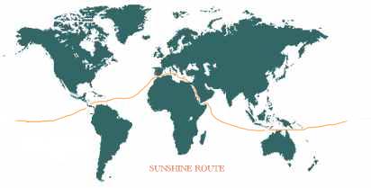
EQUATORIAL WORLD NAVIGATION ROUTE
THE ULTIMATE CHALLENGE for Solar Navigator: Many routes have been proposed, developed and investigated. The best example of which and the most likely is shown on this page as the Sunshine Route.
Nelson Kruschandl - project manager
Planning this expedition has not proved to be a simple matter. One of the most important factors to be considered is the safety of the ship and crew. Many tropical areas are only safe for six months of the year. Our route is west-about so as not to fight the prevailing winds on a course designed to capture the sun. The boats average performance and the number of provisioning stops, will determine the time of the voyage, as will the requirements of our project partners.
We hope you will in part experience the flavour of this exciting voyage from the destinations listed and learn something of the exotic locations. The World is indeed our Oyster.
Several records will be set, others to beat notably:-
1. The electric Trans-Atlantic Ocean record - to be set. 2. The electric Trans-Pacific Ocean record - 138 days to beat. 3. The electric Trans-Indian Ocean record - to be set.
THE SUNSHINE ROUTE
A date for the start of the event has yet to be set, although it is hoped for a launch in 2007 and an attempt to set a number of records in 2008. Gibraltar is where the fun begins and ends. The route will encompass both great Canals. It is hoped to transit the Panama Canal in February heading for the Galapagos and thence joining the South Equatorial Current to Indonesia via the Torres Strait by August. Still going with the S.E. trades across the Indian Ocean, then through the Suez Canal to Port Said into the Mediterranean to Malta and Gibraltar. It is expected this expedition will last 120 days.
Eventually, it is hoped to be in a position to go around the world in 80 days or less as per the above route calendar.
|
||||||||||||||||||||
|