|
ADELAIDE
Please use our A to Z INDEX to navigate this site
|
||||||||||||||||||||||||||||||||||||||||||||||||||||||||||||||||||||||||||||||||||||||||
|
Adelaide is the capital and most populous city of the Australian state of South Australia, and is the fifth largest city in Australia, with a population of over 1.1 million. It is a coastal city beside the Southern Ocean, and is situated on the Adelaide Plains, north of the Fleurieu Peninsula, between the Gulf St. Vincent and the low-lying Mount Lofty Ranges. It is roughly a linear city: it is 20 km from the coast to the foothills, but it stretches 90 km from Gawler at its northern extent to Sellicks Beach in the south.
Named in honour of Queen Adelaide, the consort of King William IV, the city was founded in 1836 as the planned capital for the only freely-settled British province in Australia. Colonel William Light, one of Adelaide's founding fathers, designed the city and chose its location close to the River Torrens. Inspired by William Penn, Light's design set out Adelaide in a grid layout, interspaced by wide boulevards and large public squares, and entirely surrounded by parkland. Early Adelaide was shaped by religious freedom and a commitment to political progressivism and civil liberties, which led to world-first reforms. Adelaidean society remained largely puritan up until the 1970s, when a set of social reforms under the premiership of Don Dunstan resulted in a cultural revival. Today Adelaide is known for its many festivals as well as for its wine, arts and sports.
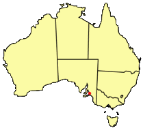
Adelaide location (red dot)
As South Australia's seat of government and commercial centre, Adelaide is the site of many governmental and financial institutions. Most of these are concentrated in the city centre along the cultural boulevard of North Terrace and in various districts of the metropolitan area.
Prior to European settlement, the Adelaide area was inhabited by the Kaurna Aboriginal tribe. Acknowledged Kaurna country comprised the Adelaide Plains and surrounding regions - from Cape Jervis in the south, and to Port Wakefield in the north. Among their unique customs were burn-offs (controlled bushfires) in the Adelaide Hills which the early Europeans spotted before the Kaurna people were pushed out by settlement. By 1852, the total population (by census count) of the Kaurna was 650 in the Adelaide region and steadily decreasing. During the winter months, they moved into the Adelaide hills for better shelter and firewood.
South Australia was officially settled as a new British province on December 28, 1836. This day is now commemorated as a public holiday, Proclamation Day, in South Australia. The site of the colony's capital city was surveyed and laid out by Colonel William Light, the first Surveyor-General of South Australia. Light chose, not without opposition, a site on rising ground close to the River Torrens, which became the chief early water supply for the fledgling colony. "Light's Vision", as it has been termed, has meant that the initial design of Adelaide required little modification as the city grew and prospered. Usually in an older city it would be necessary to accommodate larger roads and add parks, whereas Adelaide had them from the start. Adelaide was established as the centre of a planned colony of free immigrants, promising civil liberties and freedom from religious persecution, and does not share the convict settlement history of other Australian cities like Sydney and Hobart.
Adelaide's early history was wrought by economic uncertainty and incompetent leadership. The first governor of South Australia, Hindmarsh, clashed frequently with Col. Light. The rural area surrounding Adelaide city was surveyed by Light in preparation to sell a total of over 405 km² of land. Adelaide's early economy started to get on its feet in 1838 with the arrival of livestock from New South Wales and Tasmania. The wool industry served as an early basis for the South Australian economy. Light's survey was completed in this period, and land was promptly offered to sale to early colonists. Wheat farms ranged from Encounter Bay in the south to Clare in the north by 1860. Governor Gawler took over from Hindmarsh in late 1838 and promptly oversaw construction of a governor's house, gaol, police barracks, hospital, and customs house and a wharf at Port Adelaide. In addition houses for public officials and missionaries, and outstations for police and surveyors were also constructed during Gawler's governorship. Adelaide had also become economically self-sufficient during this period but at heavy cost: the colony was heavily in debt and relied on bail-outs from London to stay afloat. Gawler was recalled and replaced by Governor Grey in 1841. Grey slashed public expenditure against heavy opposition, yet its impact was negligible at this point: Silver was discovered in Glen Osmond that year, agricultural industries were well underway and other mines sprung up all over the state, aiding Adelaide's commercial development. The city exported meat, wool, wine, fruit and wheat by the time Grey left in 1845, contrasting with a low point in 1842 when one-third of Adelaide houses were abandoned.
Trade links with the rest of the Australian states were established with the Murray River being successfully navigated in 1853 by Francis Cadell, an Adelaide resident. Adelaide saw South Australia become a self-governing colony in 1856 with the ratification of a new constitution by the British parliament. Secret ballots were introduced, and a bicameral parliament was elected on 9 March 1857, by which time 109,917 people lived in the province. In 1860 the Thorndon Park reservoir was opened, finally providing an alternative water source to the turbid River Torrens. In 1867 gas street lighting was implemented, the University of Adelaide was founded in 1874, the South Australian Art Gallery opened in 1881 and the Happy Valley Reservoir opened in 1896. In the 1890s Australia was affected by a severe economic depression, ending a hectic era of land booms and tumultuous expansionism. Financial institutions in Melbourne and banks in Sydney closed. The national fertility rate fell and immigration was reduced to a trickle. The value of South Australia's exports nearly halved. Drought and poor harvests from 1884 compounded the problems with some families leaving for Western Australia. Adelaide was not as badly hit as the larger gold-rush cities of Sydney and Melbourne, and silver and lead discoveries at Broken Hill provided some relief. Only one year of deficit was recorded but the price paid was retrenchments and lean public spending. Wine and copper were the only industries not to suffer a downturn.
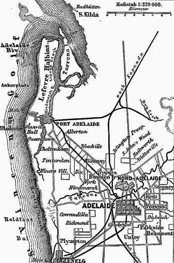
1888 Map of Adelaide showing the gradual development of its urban layout
Electric street lighting was introduced in 1900 and electric trams were transporting passengers in 1909. 28,000 men were sent to fight in World War I. Adelaide enjoyed a post-war boom but, with the return of droughts, entered the depression of the 1930s, later returning to prosperity under strong government leadership. Secondary industries helped reduce the state's dependence on primary industries. The 1933 census recorded the state population at 580,949, less of an increase than other states due to the state's economic limitations. World War II brought industrial stimulus and diversification to Adelaide under the Playford Government, which advocated Adelaide as a safe place for manufacturing due to its less vulnerable location. 70,000 men and women enlisted and shipbuilding was expanded at the nearby port of Whyalla.
The South Australian Government in this period built on former wartime manufacturing industries. International manufacturers like General Motors Holden and Chrysler make use of these factories around Adelaide completing its transformation from an agricultural service centre to a twentieth-century city. A pipeline from Mannum brought River Murray water to Adelaide in 1954 and an international airport opened at West Beach in 1955. An assisted migration scheme brought 215,000 immigrants of all nationalities to South Australia between 1947 and 1973. The Dunstan Government in the 1970s saw something of an Adelaide 'cultural revival' - establishing a wide array of social reforms and overseeing the city becoming a centre of the arts. Adelaide hosted the Australian Grand Prix between 1985 and 1996 on a street circuit in the city's east parklands, before losing it in a controversial move to Melbourne. The 1992 State Bank collapse plunged both Adelaide and South Australia into economic recession, and its effects can still be felt today. Recent years have seen the Clipsal 500 V8 Supercar race make use of sections of the former Formula One circuit and renewed economic confidence under the Rann Government.
Geography
Adelaide is located north of the Fleurieu Peninsula, on the Adelaide plains between the Gulf St Vincent and the low-lying Mount Lofty Ranges. The city stretches from the town of Gawler at its northernmost point to Aldinga in the south. According to the Australian Bureau of Statistics, the Adelaide Metropolitan Region has a total land area of 870 km², and is at an average elevation of 50 metres above sea level. Mount Lofty is located east of the Adelaide metropolitan region in the Adelaide Hills at an elevation of 727 metres. It is the tallest point in the state south of Burra.
Much of Adelaide was bushland before European settlement, with some variation - swamps and marshlands were prevalent around the coast. However, much of the original vegetation has been cleared with what is left to be found in reserves such as the Adelaide Parklands, Cleland Conservation Park and Belair National Park. A number of creeks and rivers flow through the Adelaide region. The largest are the Torrens and Onkaparinga catchments. Adelaide relies on its many reservoirs for water supply, with Mount Bold Reservoir and Happy Valley Reservoir together supplying around 50% of Adelaide's requirements.
Climate
Adelaide has a Mediterranean climate, where most of the rain falls in the winter months. Of the Australian capital cities, Adelaide is the driest. Rainfall is unreliable, light and infrequent throughout summer. In contrast, the winter has fairly reliable rainfall with June being the wettest month of the year, averaging around 80 mm. Frosts are rare, with the most notable occurrences having occurred in July 1908 and July 1982. There is usually no appreciable snowfall, except at Mount Lofty and some places in the Adelaide Hills.
Urban layout
Adelaide is a planned city, designed by the first surveyor-general of South Australia, Colonel William Light. His plan, now known as Light's Vision, arranged Adelaide in a grid, with five squares in the inner City of Adelaide and a ring of parks known as the Adelaide Parklands surrounding it. Light's design was initially unpopular with the early settlers, as well as South Australia's first Governor, John Hindmarsh. Light persisted with his design against this initial opposition. The benefits of Light's design are numerous; Adelaide has had wide multi-lane roads from its beginning, an easily-navigable grid layout and a beautiful green ring around the city centre. There are two sets of 'ring roads' in Adelaide that have resulted from the original design. The inner ring route borders the parklands and the outer route completely bypasses the inner city through (in clockwise order) Grand Junction Road, Hampstead Road, Ascot Avenue, Portrush Road, Cross Road and South Road.
The inevitable urban expansion has to some extent outgrown Light's original plan. Numerous satellite cities were built in the latter half of the 20th century, notably Salisbury and Elizabeth on the city's northern fringes, which have now been enveloped by its urban sprawl. New developments in the Adelaide Hills region facilitated the construction of the South Eastern Freeway to cope with growth. Similarly, the booming development in Adelaide's South made the construction of the Southern Expressway a necessity. New roads are not the only transport infrastrure developed to cope with the urban growth, however. The O-Bahn Busway is an example of a unique solution to Tea Tree Gully's transport woes in the 1980s. The development of the nearby suburb of Golden Grove in the late 1980s is possibly an example of well-thought-out urban planning. The newer urban areas as a whole, however, are not as integrated into the urban layout as much as older areas, and therefore place more stress on Adelaide's transportation system – although not on a level comparable with Melbourne or Sydney.
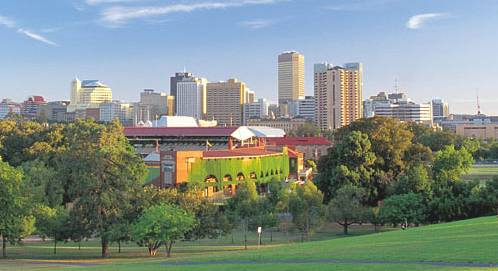
Panoramic view over the Adelaide Parklands of the Square Mile (central business district) from Montefiore Hill in North Adelaide. The historic Adelaide Oval is visible in the centre foreground
Governance
The Adelaide metropolitan area is made up of eighteen local government areas, including, at its centre, the City of Adelaide, which administers the CBD, North Adelaide, and the surrounding Adelaide Parklands. It is the oldest municipal authority in Australia and was established in 1840, when Adelaide and Australia's first mayor, James Hurtle Fisher, was elected. From 1919 onwards, the City has had a Lord Mayor, the current being Lord Mayor Michael Harbison.
Adelaide, as the capital of South Australia, is the seat of the state Government of South Australia. As Adelaide is South Australia's capital and most populous city, the State Government co-operates extensively with the City of Adelaide. In 2002, the Ministry for the City of Adelaide was created to facilitate the state government's collaboration with the Adelaide City Council and the Lord Mayor to improve Adelaide's image. The state parliament's Capital City Committee is also involved in the governance of the City of Adelaide, being primarily concerned with the planning of Adelaide's urban development and growth.
Demographics
As of June 2004, Adelaide had a metropolitan population of more than 1,124,315, making it Australia's fifth largest city. In the 2002-2003 period the population grew by 0.6%, while the national average was 1.2%. Some 70.3% of the population of South Australia are residents of the Adelaide metropolitan area, making South Australia one of the most centralised states. Major areas of population growth in recent years were in outer suburbs such as Mawson Lakes and Golden Grove. Adelaide's inhabitants occupy 325,000 houses, 57,000 detached, row terrace or town houses and 49,000 flats, apartments and caravans.
Overseas-born Adelaideans composed 24.6% (242,092) of the total population. The North-Eastern Suburbs (such as Golden Grove and Salisbury) and suburbs close to the CBD had a higher ratio of overseas-born residents. Wealthier and more well-educated Adelaideans are concentrated on the coastal suburbs (such as Brighton and Hallett Cove) and South-Eastern suburbs (such as Burnside and Waterfall Gully). Almost a fifth (17.9%) of the population had university qualifications. The number of Adelaideans with vocational qualifications (such as tradespersons) fell from 62.1% of the labour force in the 1991 census to 52.4% in the 2001 census.
Overall, Adelaide is ageing much more rapidly than other Australian capital cities. Just under a quarter (24.1%) of Adelaide's population is aged 55 years or older, in comparison to the national average of 19.9%. To further compound the situation, Adelaide has the lowest number of children (under-15 year olds), which composed 18.7% of the population, compared to the national average of 20.4%. In regards to three highest ancestries, 38% of the population identified themselves as English, 34% as Australian (most likely primarily of Anglo-Celtic background) and 8.4% as Irish. The most-spoken languages other than English were: 3.5% Italian, 2.3% Greek, 1.2% Vietnamese, 0.7% Polish and 0.7% German.
Economy
Adelaide's economy is primarily based around manufacturing, defence technology and research, commodity export and corresponding service industries. It has large manufacturing, defence and research zones. They contain car manufacturing plants for General Motors Holden and Mitsubishi, and plants for medical equipment and electronic component production. Almost half of all cars produced in Australia are made in Adelaide. The global media conglomerate News Corporation was founded in and until 2004 incorporated in Adelaide and is still considered its 'spiritual' home by Rupert Murdoch. Australia's largest oil company, Santos (South Australia Northern Territory Oil Search) and the prominent South Australian brewery, Coopers, call Adelaide their home. The collapse of the State Bank in 1992 resulted in large levels of state debt (as much as A$4 billion). The collapse had meant that successive governments had enacted lean budgets, cutting spending, which had been a setback to the further development of the city and state. The debt has recently been reduced with the State Government once again receiving a AAA+ Credit Rating. The South Australian economy, very closely tied to Adelaide's, still enjoys a trade surplus and has higher per capita growth than Australia as a whole.
Adelaide is home to a large proportion of Australia's defence industries which contribute over AUD$1 billion to South Australia's Gross State Product. 70% of Australian defence companies are located in Adelaide. The principal government military research institution, the Defence Science and Technology Organisation, and other defence technology organisations such as Tenix are located in Salisbury near RAAF Base Edinburgh and others near Technology Park. The Australian Submarine Corporation, based in the industrial suburb of Osborne was charged with constructing Australia's Collins class submarines and recently won a AUD$6 billion contract to construct the Royal Australian Navy's new air-warfare destroyers.
There are 466,829 employed people in Adelaide, with 62.3% full-time and 35.1% part-time. In recent years there has been a growing trend towards part-time (which includes casual) employment, increasing from only 11.6% of the workplace in 1991, to over a third today. 15% of workers are employed in manufacturing, 5% in construction, 15% in retail trade, 11% in business services, 7% in education and 12% in health and community services. The median weekly individual income for people aged 15 years and over is $300-$399 per week. The median family income is $800-$999 per week. Adelaide's housing and living costs are substantially lower than that of other Australian cities, with housing being notably cheaper. The median Adelaide house price is half that of Sydney and two-thirds that of Melbourne. The unemployment rate in October 2005 was 4.8%.
LINKS and REFERENCE
GENERAL LINKS
Australian Government Entry Portal Commonwealth Government Online Department of Immigration and Multicultural and Indigenous Affairs (DIMIA) Satellite images of Australia (Google Maps) Official Australia Tourism Website Official website of the Melbourne 2006 Commonwealth Games
Solar Cola drinkers care about planet earth
.. Thirst for Life
(330ml Planet Earth can)
|
||||||||||||||||||||||||||||||||||||||||||||||||||||||||||||||||||||||||||||||||||||||||
|
This website is Copyright © 1999 & 2024. The bird logo and name Solar Navigator and Solar Cola are trademarks. All rights reserved. All other trademarks are hereby acknowledged. Max Energy Limited is an environmental educational charity.
|
||||||||||||||||||||||||||||||||||||||||||||||||||||||||||||||||||||||||||||||||||||||||