|
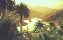
The
Canary Islands have a climate of their own, due in the first
place to their geographical position in the middle of the Atlantic, near the African coast; secondly, because of their
place in the path of the trade winds, which are responsible
for the peculiar character of their climate, and thirdly,
because of the variety of their geographical features, ie, the
more mountainous islands have more rain, such as Tenerife, La
Palma and Gran Canaria, and the less rugged ones, such as
Fuerteventura and Lanzarote, have less rain. Consequently, the
mountains have a direct bearing on the amount of rain that
falls and not the proximity of the African continent, as is
commonly believed.
All
the climatic indicators based on the sensation experienced by
the human body when the values of temperature, humidity and
wind speed are combined coincide in showing that the islands
have the best possible conditions for eternal spring
throughout the year.
Location:
29.0N, 13.6W
Elevation: 2,060 feet (670 m)
Isla
de Lanzarote
The
aborigines called the island 'Tite-roy-gatra', or Red
Mountain; the Romans called it 'Pupuria' because of the
abundance of purple lichen (orchil), but the name Lanzarote
comes from the Island's discovery by the Genoese, Lancelotto
Malocello, who reclaimed it from the obscurity it had fallen
into since classical times.
About
100 km off the African coast, Lanzarote is in the temperate
zone of the Tropic of Cancer, warmed by the Saharan
temperatures meeting the Gulf Stream. One
of the many reasons for coming to the archipelago is to see
why UNESCO, in 1993, declared this flat, volcanic Island of
sparse vegetation and fields of lava as a World Biosphere
Reserve.
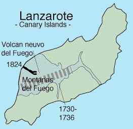
Lanzarote,
in common with the other Islands is a shield volcano made of
prominent fissure vents, approximately 20 million years old.
There are four main calderas and numerous cones and fissures.
Basalts erupted in 1730-1736 and 1824 cover about one fourth
of the surface of the island. The vents for the 1730-1736
eruption are near Montanas del Fuego. The 1824 eruption lasted
about three months and was focused at the Nuevo del Fuego
vent. The north end of the Island of Fuerteventura can be seen
near the bottom of the photo. The shape of the island differs
on space photos compared to maps. However, both views
are correct. The map shows the island as it would be seen
looking directly down on it, with no distortion. The space
photo was taken through the window of the Space Shuttle when
the island was off to the side. The oblique view made the
island look shorter.
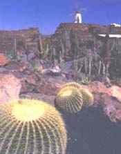
Cactus
Garden
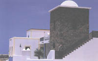
Lanzarote
architecture
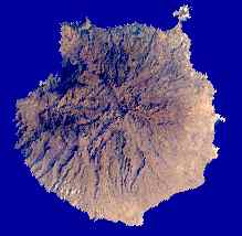
Gran
Canaria
Location:
28.00N, 15.58W
Elevation: 6,398 feet (1,950 m)
Folklore
and crafts
Popular
songs and dances have a characteristic cadence, in which
contributions from the Peninsula mingle with a native basis.
An exotic, original feeling is conveyed by the expressive
stances of the dancers, by the many coloured costumes, which
are different on every island, by the rhythm of the melodies -
some of which have airs of a certain languid slowness. The isa
and the folias are the most popular songs and dances, apart
from the malagueña of Andalusian origin, which has taken root
in the Canaries. The typical musical instrument used for
accompaniment is the timple, a kind of ukulele with a
harmonious sound. Crafts mainly take the form of openwork and
embroidery, which are done by Canary women with great skill
and refined taste. It may be said that the first Canary
greeting which the traveller receives upon his arrival in the
islands are examples of this delicate work shown and on sale
everywhere. Pottery also has a long tradition and is of the
greatest interest, as is making baskets with palm leaves, reed
and wicker. Delicate objects are also produced by carving wood.
Gran
Canaria
Shopping
The
Canary Islands are a shopping paradise because there is no
customs barrier. Not even the tax-free shops at the airports
can compete with prices in the Canaries. Liqueurs,
tobacco, cameras and film cameras, tape recorders, transistor
radios, watches, everything is cheaper than in their countries
of origin.
Communications
The
Canary archipelago is connected with Europe, Africa, but
especially with the Spanish peninsula, by numerous sea and air
links. The
shortest distance between these islands and Africa is 115 Km.
From Gran Canaria and Tenerife to the port of Cádiz, there
are 680 and 705 miles, respectively, the equivalent of two
days at sea. Direct flights by jet from Madrid take a little
over two hours. Every island, with the exception of Gomera,
has airports for national and international flights. For the
moment, the airport on the island of El Hierro only receives
national flights. There are numerous air and sea links between
the different islands of the archipelago. Especially between
Tenerife and Gran Canaria there are several air and sea links
every day.
Cooking
Canary
cooking includes many dishes prepared with fish caught in
large amounts along the coast. Fish is served with the famous
papas arrugadas, potatoes boiled in salt water, and a hot
sauce called mojo. Traditional dishes are watercress stew, the
popular sancocho canario, made with salted fish and mojo,
rabbit in salmorejo, a sauce consisting of water, vinegar,
olive oil, salt and pepper, sweet black pudding, etc. Banana
and tomato, the main source of wealth of the islands, also
occupy an important place in Canary cooking as do avocado pear
and papaya fruit as well as gofio, a roasted mixture of wheat,
maize or barley, which is eaten with certain dishes of the
country instead of bread. Among the sweets, especially
outstanding are tirijalas, bienmesabes, frangollo, bizcochos
lustrados, turrones de melaza or gofio and pastry. Typical of
the island of El Hierro are quesadillas and of La Palma
rapaduras and marquesotes. Among the drinks produced in the
islands, there are especially rum, rum-cum-honey, malmsey wine
and the reds from Tacoronte. A splendid complement to a
Canary meal is the excellent, native tobacco, world-famous
because of the quality and variety of its tastes, among which
the typical cigars, exported to countries of all kinds deserve
special mention.
Palmeras
The
temperature variations between the different seasons are
especially eye-catching: 6C (42.8F) between the warmest and
the coldest month. The number of really good days varies from
between 90 per cent in August and 50 per cent in January, and
it is typical for them to be mild - between 18 and 24C (64.4
and 75.2F) -, with clean, fresh air, a rather high degree of
humidity (80 per cent) and a partially clouded sky in places
lying east of the mountains and close to them. The less
agreeable days with a southern African wind only account for 7
per cent (26 days in the whole year). At the same time, its
mountainous features produce temperature changes depending on
the altitude so that even snow is found on some peaks.
The
so-called Canary current contributes to the mild climate. It
keeps the surface temperature of the sea below that
corresponding to the latitude. The mean temperature of the sea
water is 22 in the summer and 19 in the winter. As a
result of their pleasant spring with a mean temperature of 18C
(64.4F) and their splendid summer with 22C (71.6F), the
climate of these marvelous islands is unmatched and the
feeling of well-being constant.
Sports
The
islands are the ideal setting for the practice of all kinds of
sports. There are many fans of underwater fishing, swimming
and whatever other sports there are on the beach and at the
swimming pools. The traveller has a thousand training
possibilities at the tennis courts, trap-shooting, riding
clubs and the magnificent golf courses with a perfect lawn on
undulating terrain. There are also occasions to get to know
local sports, such as cock fights, the game of sticks, a kind
of fencing with two long poles, and the famous Canary catch
as-catch-can of remote origin, which requires great skill and
strength and is a spectacle of major interest. Another
tradition is el salto del regatón or de la garrocha,
practiced above all in the island of La Palma.
Gran
Canaria
Temperatures:
Minimum, 18ºC in January. Maximum, 24.5ºC in July
Canary
Underwater Activities Federation:
C/ San Sebastián, 76. 2º Floor Santa Cruz de Tenerife Tel:
922 22 67 71 Fax: 922 22 04 85
Canary
Underwater Activities Delegation:
Apdo. de Correos 1339. Las Palmas de Gran Canaria Tel-fax: 928
23 49 45
Canary
Water-Skiing Federation:
C/ Pérez Reyes. Pabellón de Deportes de Tacoronte 38350
Tacoronte. Santa Cruz de Tenerife Tel-fax: 922 57 28 13
Canary
Sailing Federation:
Muelle Deportivo, s/n. Las Palmas de Gran Canaria Tel: 928 23
47 69 Fax: 928 24 24 68
Vela
Latina Federation (local sport):
Explanada Muelle Deportivo, s/n. Las Palmas de Gran Canaria
Tel: 928 23 06 16 Fax: 928 29 33 56
Canary
Canoeing Federation:
C/ Alemania, 62. Bajo. Las Palmas de Gran Canaria Tel: 928 29
07 16 Fax: 928 24 0l 94
Tenerife
Inter-Island Council Sailing School:
Vía Auxiliar Paso Alto, s/n. Valleseco 38150 S/C de Tenerife
Tel: 922 59 72 58
Canary
Speed Boating Federation:
C/ San Sebastián, 74. 1ºD. 38005 Santa Cruz de Tenerife Tel:
922 20 48 07
Sea
Sports School in San Sebastián de La Gomera:
Plaza de Las Américas, 4. 38800 San Sebastián de La Gomera
Tel: 922 14 10 72
Sources
of Information:
Carracedo,
J.C., 1994, The Canary Islands: an example of structural
control on the growth of large oceanic-island volcanoes. J.
Volcanology and Geothermal Research, v. 60, p. 225-241.
Carracedo,
J.C., 1996, Morphological and structural evolution of the
western Canary Islands: hotspot-induced three-armed rifts or
regional tectonic trends? J. Volcanology and Geothermal
Research, v. 72.
Krafft,
M., and de Larouziere, F.D., 1991, Guide des Volcans d'Europe
et des Canaries, Delachaux et Niestle, Lausanne, 455 p.
Neumann
van Padang, M., Richards, A.F., Machado, F., Bravo, T., Baker,
E., Le Maitre, W., 1967, Part XXI, Atlantic Ocean: Catalogue
of the active volcanoes of the world, International
Association of Volcanology, Rome, Italy, 128 p.
Simkin,
T., and Siebert, L., 1994, Volcanoes of the World: Geoscience
Press, Tucson, Arizona, 349 p.
|
Adelaide
Aden
- Yemen
Afghanistan
Africa
Alaska
Albania
Algeria
Amazon
Rainforest
Amsterdam
Antarctic
Arctic
North Pole
Argentina
Asia
Athens
Atlantis
- Plato's Lost City
Australia
Austria
Aztecs
- Mexico
Baghdad
Bahamas
Bahrain
Bangladesh
Barbados
Beachy
Head, England
Belgium
Benin
Berlin
Bermuda
Black
Rock Desert
Bohemia
Bolivia Bonneville
Utah History
Bonneville,
Utah, USA
Brazil
Brighton
- West Pier
British
Columbia
Buckingham
Palace
Bulgaria
Burkina
Faso
Burma
California
Canada
Canary
Islands
Cape
Horn
Cape
Verde
Cape
York - Au
Caribbean
Cayman
Islands
Central
Africa
Chichester
Harbour
Chile
China
Columbo
- Sri Lanka
Columbia
Corfu
Cowes,
Isle of Wight
Croatia
Crooked
Island, Bahamas
Cuba
Cyprus
Czechoslovakia
Darwin
- Australia
Daytona
Beach
Denmark
Eastbounre
Pier, England
Earthquakes
Ecuador
Egypt
Eindhoven Estonia
Equator
Europe
Falkland
Islands
Falmouth,
Cornwall
Fiji
Finland
France
Galapagos
Islands
Geography
Links
Geography
Mountains
Geography
Records
Geography
Resources
Geography
Statistics
|
Germany
Ghana
Gibraltar
- Links
Greece
Greenland
Guinea
Guinea
Bissau
Hawaii
Holland
the Nertherlands
Hollywood,
California, LA
Hong
Kong
Hungary
Hurricanes
Iceland
India
Indonesia
Links
Iran
Iraq
Ireland
Isle
of Man
Isle
of Wight
- The
Needles
Israel
Italy
Ivory
Coast
Jakarta
- Java
Japan
Johannesburg
Jordan
Kent,
England
Kenya
Korea
Kuwait
Kyoto
Lanzarote,
Gran Canaria
Las
Vegas
Lebanon
Liberia
Libya
Liechtenstein
Life
on Earth
Lithuania
London
- Big
Ben
London
Eye
London
Houses
Parliament
London
- Buckingham
Palace
London
- Old
Bailey
London
- Overview
London
- The City
London
- Tower Bridge
London
- Trafalgar
Square
Luxembourg
Madame
Tussauds
Malaysia
Mali
Malta
Marshal
Islands
Mauritania
Maya
Empire -
Central America
Melbourne,
Australia
Middle
East
Melbourne,
Australia
Mexico
Monaco
Morocco
Mountains
Mumbai
Naples-
Italy
National
Geographic
Nepal
New
York
New
Zealand
Niger
Nigeria
North
Africa
Norway
Nova
Scotia
Oceans
and Seas
Oman
Pakistan
Palermo
- Sicily
Palestine
Palma
- Malorca
|
Panama
Canal - Links
Paris
Pendine
Sands
Peru
Philippines
Pisa,
Leaning Tower
Planet
Earth
Poland
Port
Moresby - PNG
Port
Said - Egypt
Portugal
Puerto
Rico
Qatar
Quebec
Rio
de Janeiro
Romania
Rome
Russia
Salt
Lake City
Samoa
Saudi
Arabia
Scandanavia
Scotland
Senegal
Siera
Leone
Singapore
Solomon
Islands
Somalia
South
Africa
South
America
Southampton
Spain
- Espana
Sri
Lanka - Links
Stonehenge
Sudan
Suez
Canal
Sundancer
Holiday Resort
Sussex,
England Index
Sweden
Switzerland
Sydney,
Australia
Syria
Tahiti
- Polynesia
- Links
Tahitian
- Men & Women Customs
Taiwan
Thailand
The
Gambia
Togo
Tokyo,
Japan
Tonga
- Polynesia
Toronto
Trinidad
- Lesser Antilles
Trinidad
and Tobago
Tsunami
Tunbridge
Wells, England
Tunisia
Turkey
Tuvalu
Islands
UAE
- United Arab Emirates
UK
Statistics
Ukraine
United
Kingdom
United
Kingdom -
Gov
USA
Uruguay
Vanuatu
Islands
Vatican
City
Venezuela
Venice
Vienna
Vietnam
Volcanoes
Volendam
Wales
Washington
D.C.
WAYN
Where Are You Now
Wealden
iron industry
Wendover
West
Africa
World
Peace Supporters
Yemen
Yugoslavia
Zurich
|

Solar
Cola drinkers care about planet
earth
..
Thirst for Life

(330ml
Planet Earth can)
|