|
BAHAMAS
|
|||
|
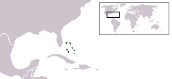
The Commonwealth of the Bahamas is an independent English-speaking nation in the West Indies. An archipelago of 700 islands and cays, the Bahamas is located in the Atlantic Ocean, east of Florida and the United States, north of Cuba and the Caribbean, and northwest of the British dependency of the Turks and Caicos Islands.
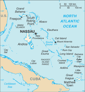
Map of the Bahamas
History
Christopher Columbus' first landfall in the New World was on the island of San Salvador, also called Watling's Island, in the south part of Bahamas where he encountered the indigenous Tainos (commonly known as the Lucayan) and exchanged gifts with them.
Taino Indians from the north part of Hispaniola and north part of Cuba moved into the south area of The Bahamas in maybe the 7th century and became the Lucayans. It seems as though they settled by the 12th century AD. There were maybe 40,000 Lucayans living in the Bahamas when Columbus came through.
The Bahamian Lucayans were taken to Hispaniola as slaves, and in two decades, many Lucayan societies stopped existing because of forced labour, warfare, disease, emigration and outmarriage.
After the Lucayans were gone, the Bahamian islands were left alone with no one in them until the English settlers came from Bermuda in 1650. They were the Eleutherian Adventurers, those people established settlements on the island that was then called Eleuthera. The Bahamas became a British crown colony in 1718. Some 8,000 loyalists and their slaves moved to the Bahamas in the late 1700s from New York, Florida and the Carolinas.
The British made the islands internal self-government in 1964 and, in 1973, Bahamians got full independence while staying a member of the Commonwealth of Nations. Since the 1950s, the Bahamian economy has prospered based on the twin pillars of tourism and financial services. Despite this however the country still faces significant challenges in areas such as education, healthcare, correctional facilites and violent crime and illegal immigration. The urban renewal project has been launched in recent years to help impoverished urban areas in social decline in the main islands. Today, the country enjoys the third highest per capita income in the western hemisphere.
Some say the name 'Bahamas' derives from the Spanish for "shallow sea", baja mar. Others trace it to the Lucayan word for Grand Bahama Island, ba-ha-ma ("large upper middle land").
Bahamas - world location map
Geography and climate
The Bahamas is an archipelago of some 700 islands and 2000 cays covering over 100,000 mi² (260,000 km²) of the Atlantic Ocean between Florida and Hispaniola. The archipelago has a total land area of 5,382 square miles (13,939 km²)—about 20% larger than Jamaica—and a population of some 310,000 concentrated on the islands of New Providence and Grand Bahama.
The largest island is Andros Island. The Biminis are just 50 miles (80 km) east of Florida. The island of Grand Bahama is home to the second largest city in the country, Freeport. The island of Abaco is to its east. The most southeastern island is Inagua. Other notable islands include Eleuthera, Cat Island, San Salvador, Acklins, Crooked Island, Exuma and Mayaguana. Nassau is the capital and largest city, located on New Providence. The islands have a subtropical climate, moderated by the Gulf Stream.
In the southeast, the Caicos Islands and the Turks islands, and three more extensive submarine features called Mouchoir Bank, Silver Bank, and Navidad Bank, are geographically a continuation of the Bahamas, but not part of the Commonwealth of the Bahamas.
The climate of the Bahamas is subtropical to tropical, and is moderated significantly by the waters of the Gulf Stream, particularly in winter. Conversely, this often proves very dangerous in the summer and autumn, when hurricanes pass near or through the islands. Hurricane Andrew hit the northern islands in 1992, and Hurricane Floyd hit most of the islands in 1999. Hurricane Frances of 2004 was expected to be the worst ever for the islands. Also in 2004, the northern Bahamas were hit by a less potent Hurricane Jeanne. In 2005 the northern islands were once again struck this time by Hurricane Wilma. Tidal surges and high winds destroyed homes, schools, floated graves and made roughly 1,000 people homeless. The homeless people were stuck without food, water and resources and were left to depend on the government.
A taste for adventure capitalists
Solar Cola - a healthier alternative
|
|||
|
This website is Copyright © 1999 & 2024. The name Solar Navigator is a trademark. All rights reserved. All other trademarks are hereby acknowledged. Max Energy Limited is an educational charity.
|