|
BARBADOS
|
||||
|
Barbados is an independent island nation located in the western Atlantic Ocean, just to the east of the Caribbean Sea, found at roughly 13° north of the Equator and 59° west of the Prime Meridian. Located relatively close to South America the nation of Barbados is around 434.5 kilometres (270 miles) northeast of the South American nation of Venezuela.
The closest island neighbours to Barbados are Saint Lucia and Saint Vincent and the Grenadines both located to the west Trinidad and Tobago to the south and Grenada to the south-west. Barbados is part of Lesser Antilles.
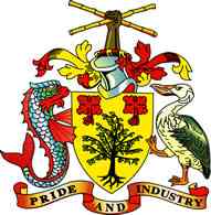
Barbados coat of arms
Barbados possesses a land area of around 430 square kilometres, (166 sq. mi), and is primarily low-lying, with some higher regions in the island's interior. The organic composition of Barbados is thought to be of non-volcanic origin and is predominantly composed of limestone-coral. The island's atmosphere is sub-tropical with constant trade winds off the Atlantic Ocean and some undeveloped areas contain marshes and mangrove swamps. Other parts of the island's interior contributing the island's agricultural sector are dotted with large sugarcane estates and wide gently sloping pastures with many good views down to the sea.
Barbados has one of the highest standards of living and literacy rates in the developing world and, according to the United Nations Development Programme (UNDP), Barbados is currently the No. 4 most developed of all developing countries in the world. Despite its small geographical size, Barbados constantly ranks in the top 30 (or 31) countries in the HDI (Human Development Index) rankings. The island is also a major tourist destination.
History
The earliest inhabitants of Barbados were Amerindian nomads. Three waves of migrants moved north toward North America. The first wave was of the Saladoid-Barrancoid group, who were farmers, fishermen, and ceramists that arrived by canoe from South America (Venezuela's Orinoco Valley) around 350 CE. The Arawak people were the second wave of migrants, arriving from South America around 800 CE. Arawak settlements on the island include Stroud Point, Chandler Bay, Saint Luke's Gully, and Mapp's Cave. According to accounts by descendants of the aboriginal Arawak tribes on other local islands, the original name for Barbados was Ichirouganaim. In the 13th century, the Caribs arrived from South America in the third wave, displacing both the Arawak and the Salodoid-Barrancoid. For the next few centuries, the Caribs—like the Arawak and the Salodoid-Barrancoid—lived in isolation on the island.
The name "Barbados" comes from a Portuguese explorer named Pedro Campos in 1536, who originally called the island Os Barbados ("The Bearded Ones") upon seeing the appearance of the island's fig trees whose long hanging aerial roots, he thought, resembled beards. Between Campos' sighting in 1536 and 1550, Spanish conquistadors seized many Caribs on Barbados and used them as slave labour on plantations. Other Caribs fled the island, moving elsewhere.
British sailors who landed on Barbados in the 1620s at the site of present-day Holetown on the Caribbean coast found the island uninhabited. From the arrival of the first British settlers in 1627–1628 until independence in 1966, Barbados was under uninterrupted British control. Nevertheless, Barbados always enjoyed a large measure of local autonomy. Its House of Assembly began meeting in 1639. Among the initial important British figures was Sir William Courten.
Starting in the 1620s an increasing number of black slaves were brought to the isle. 5000 locals died of fever in 1647, and hundreds of slaves were executed by Royalist planters during the English Civil War in the 1640s, as they feared that the ideas of the Levellers might spread to the slave population if Parliament took control of Barbados.
Large numbers of Celtic people, mainly from Ireland and Scotland, went to Barbados as indentured servants. Over the next several centuries the Celtic population was used as a buffer between the Anglo-Saxon plantation owners and the larger African population, variously serving as members of the Colonial militia and playing a strong role as allies of the larger African slave population in a long string of colonial rebellions. As well, in 1659, the English shipped many Irishmen and Scots off to Barbados as slaves. With King James II, and other kings in his dynasty, also sending Scots, and English, off to the isle. For instance in 1685, after the crushing of the Monmouth Rebellion. The modern descendants of this original slave population are sometimes derisively referred to as Red Legs, or locally 'ecky becky' and are some of the poorest inhabitants of modern Barbados. There has also been large scale intermarriage between the African and Celtic populations on the islands. Because the Africans could withstand tropical diseases and the climate much better than the white slave population, and also because those poor whites who had or acquired the means to emigrate often did so, Barbados turned from mainly Celtic in the 17th century to overwhelmingly black by the 20th century.
As the sugar industry developed into the main commercial enterprise, Barbados was divided into large plantation estates that replaced the small holdings of the early British settlers. Some of the displaced farmers relocated to British colonies in North America, most notably South Carolina. To work the plantations, West Africans were transported and enslaved on Barbados and other Caribbean islands. The slave trade ceased in 1804. Slaves though carried on being oppressed, causing, in 1816, the major slave rebellion, in the isle's history. One thousand people died in the revolt for freedom, with 144 slaves executed, and 123 deported, by the king's army. Eighteen years later slavery was abolished in the British Empire in 1834. In Barbados and the rest of the British West Indian colonies, full emancipation from slavery was preceded by an apprenticeship period that lasted six years.
However, plantation owners and merchants of British descent still dominated local politics, due to the high income qualification required for voters. More than 70% of the population, many of them disenfranchised women, were excluded from the democratic process. It was not until the 1930s that the descendants of emancipated slaves began a movement for political rights. One of the leaders of this movement, Sir Grantley Adams, founded the Barbados Labour Party, then known as the Barbados Progressive League, in 1938. Though a staunch supporter of the monarchy, Adams and his party demanded more for the poor and for the people. Progress toward a more democratic government in Barbados was made in 1942, when the exclusive income qualification was lowered and women were given the right to vote. By 1949 governmental control was wrestled from the planters and, in 1958, Adams became Premier of Barbados.
From 1958 to 1962, Barbados was one of the ten members of the West Indies Federation, an organisation doomed by nationalistic attitude and by the fact that its members, as colonies of Britain, held limited legislative power. Adams' leadership of the Federation (he served as its first and only "Prime Minister"), his failed attempts to form similar unions, and his continued defence of the monarchy demonstrated that he was no longer in touch with the needs of his country. Errol Walton Barrow, a fervent reformer, was to become the new people's advocate. Barrow had left the BLP and formed the Democratic Labour Party as a liberal alternative to Adams' conservative government. To this day, Barrow remains a beloved hero in the eyes of Barbadians, as it was he who instituted many of the reforms and programs currently in place, including free education for all Barbadians, regardless of class or colour, and the School Meals system. By 1961, Barrow had replaced Adams as Premier and the DLP controlled the government.
With the Federation dissolved, Barbados had reverted to its former status, that of a self-governing colony. The island negotiated its own independence at a constitutional conference with the United Kingdom in June 1966. After years of peaceful and democratic progress, Barbados finally became an independent state within the Commonwealth of Nations on November 30, 1966, with Errol Barrow serving as its first Prime Minister.
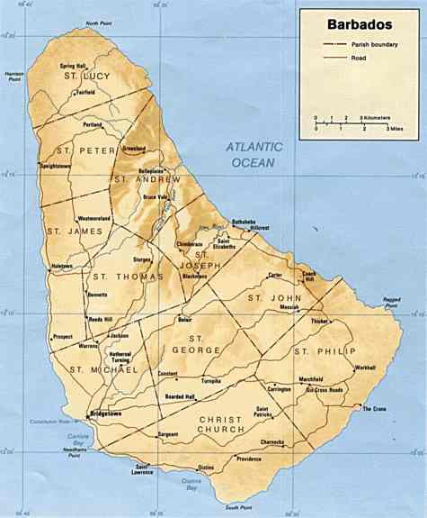
Map of Barbados
Politics
Barbados is a parliamentary democracy. Executive authority is vested in the Prime Minister and Cabinet, which is collectively responsible to the Parliament. The Prime Minister is appointed by the Governor General as the member of the House of Assembly best able to command the support of the majority of the members. The Prime Minister usually selects a cabinet from his party members in the legislature. The present government is proposing that Barbados become a republic within the Commonwealth of Nations, with a ceremonial president replacing the British Sovereign. This issue is still being hotly debated as the island has been governmentally autonomous for decades.
Barbados has been an independent state in the Commonwealth since November 30, 1966, and as such functions as a parliamentary democracy modelled after the British Westminster system. Control of the government is held by the Cabinet and is responsible to the Parliament, which comrpises a 30-seat House of Assembly and a 21-seat Senate. Barbados is one of the most secure democracies in the Caribbean. Executive power is in the hands of the prime minister and his cabinet. The prime minister is usually the leader of the winning party in the elections for the House of Assembly, whose members are elected every five years. The Senate has 21 members, and its members are appointed by the governor general.
Barbados is a full and participating member of the Caribbean Community (CARICOM), the Caribbean (CARICOM) Single Market and Economy (CSME), the Caribbean Court of Justice (CCJ) [which currently only pertains to Barbados and Guyana, and is expected to replace the UK Privy Council for the entire English speaking Caribbean eventually], and the Association of Caribbean States (ACS).
Geography
Barbados is a relatively flat island, rising gently to the central highland region, the highest point being Mount Hillaby, in the Scotland district, at 336 metres (1,100 ft) above sea level. The island is located in a slightly eccentric position in the Atlantic Ocean, to the east of the other Caribbean islands. The climate is tropical, with a rainy season from June to October.
Barbados is often spared from the amount of tropical storms and hurricanes during the rainy season due to its far eastern location in the Atlantic Ocean pushing it just outside of the principal hurricane belt. The island does get brushed or hit about every 3 years and the average number of years between direct hurricane hits is about once every 26.6 years.
In the parish of Saint Michael lies Barbados' capital and chief city Bridgetown. Locally Bridgetown is sometimes referred to as "The City," but the most common reference is simply "Town". Other towns scattered across the island include Holetown, in the parish of Saint James; Oistins, in the parish of Christ Church; and Speightstown, in the parish of Saint Peter.
The island is 23 kilometres (14 mi) at its widest point, and about 34 kilometres (21 mi) long.
LINKS and RESOURCES
Government
Directories
Tourism
Other
Solar Cola drinkers care about planet earth
.. Thirst for Life
(330ml Planet Earth can)
|
||||
|
This website is copyright © 2024 Electrick Publications. All rights reserved. The bird logo and names Solar Navigator and Blueplanet Ecostar are trademarks ™. The Blueplanet vehicle configuration is registered ®. All other trademarks hereby acknowledged and please note that this project should not be confused with the Australian: 'World Solar Challenge'™which is a superb road vehicle endurance race from Darwin to Adelaide. Max Energy Limited is an educational charity working hard to promote world peace.
|