|
MALTA
Please use our A to Z INDEX to navigate this site
|
|||
|
Malta, officially the Republic of Malta, is a small and densely populated island nation consisting of an archipelago of seven islands in the middle of the Mediterranean Sea. Malta lies directly south of Sicily, east of Tunisia and north of Libya. The country's official languages are Maltese and English. Roman Catholicism is the most common religion. The strategically located islands constituting the Maltese nation have been ruled by various powers and fought over for centuries. Malta has been a member state of the European Union since May 1, 2004. It is currently the smallest European Union country in both population and area. Malta is the only nation in the world whose flags bear a decoration awarded by a foreign country, the British George Cross.
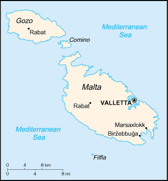
Map of Malta
History
Malta has been inhabited since around 5200 BC. A significant prehistoric Neolithic culture marked by Megalithic structures existed on the islands during its pre-history, predating the Pyramids of Giza by a millennium. Phoenicians colonized the islands around 1000 BC, using them as an outpost from which they expanded sea explorations and trade in the Mediterranean.
The islands later came under the control of Carthage (400 BC) and then of Rome (218 BC). The islands prospered under Roman rule, during which time they were considered a Municipium and a Foederata Civitas. Many Roman antiquities still exist, testifying to the close link between the Maltese inhabitants and the people of Rome. In AD 60, the islands were visited by Saint Paul, who is said to have been shipwrecked on the shores of the aptly-named "Saint Paul's Bay".
After a period of Byzantine rule (4th to 9th century) and a probable sack by the Vandals, the islands were conquered by the Arabs in AD 870. The Arabs, who generally tolerated the population's Christianity, introduced the cultivation of citrus fruits and cotton, irrigation systems, and most notably, the Arabic language, which the majority of the population adopted as their mother tongue. Arabic influence can be seen most prominently in the modern Maltese language, which has also been influenced to a lesser extent by Romance languages and is written in a variety of the Latin alphabet.
The period of Arab rule lasted until 1091, when the islands were taken by the Sicilian Normans. Subsequent rulers included the Angevine, the Hohenstaufen, and the Aragnese (1283). The Maltese nobility was established during this period; some of it dating back to 1400. About 32 noble titles remain in use today, of which the oldest is "Barons of Djar il Bniet and Buqana".
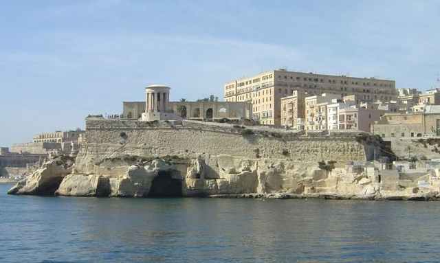
In 1530, the islands were given by Spain to the Order of Knights of the Hospital of St John of Jerusalem in perpetual lease. (The Kingdom of Aragon had owned the islands as part of their Mediterranean empire for some time). These knights, a military religious order now known as the "Knights of Malta", had been driven out of Rhodes by the Ottoman Empire in 1522. They withstood a full-blown siege by the Ottoman Turks in 1565. The Turks, at that time, were considered to be the greatest non-European military power. After this they decided to increase the fortifications, particularly in the inner-harbour area, where the new city of Valletta, named after Jean Parisot de la Valette, was built.
Fortifications of Malta harbor
Their reign ended when Malta was captured by Napoleon en route to his expedition of Egypt during the French Revolutionary Wars in 1798. As a ruse, Napoleon asked for safe harbour to resupply his ships, and then turned his guns against his hosts once safely inside Valetta. Grand Master Ferdinand von Hompesch zu Bolheim capitulated, and Napoleon stayed in Malta for a few days, during which he systematically looted the movable assets of the Order, and established an administration controlled by his nominees. He then sailed for Egypt, leaving a substantial garrison in Malta. The occupying French forces were unpopular, however, due particularly to their negative attitude towards religion. The Maltese rebelled against them, and the French were forced behind the fortifications. Great Britain, along with the Kingdom of the Two Sicilies, sent munitions and aid to the rebels. Britain also sent her navy, which instigated a blockade of the islands. The isolated French forces, under General Claude-Henri Belgrand de Vaubois, surrendered in 1800, and the island became a British protectorate, being presented by several Maltese leaders to Sir Alexander Ball.
In 1814, as part of the Treaty of Paris, Malta officially became a part of the British Empire, and was used as a shipping way-station and fleet headquarters. Malta's proximity to the Suez Canal proved to be its main asset during these years, and it was considered to be a most important stop on the way to India. In the 1930s, due to Malta's cultural and geographical proximity to Italy, the British Mediterranean Fleet was moved to Alexandria. Malta played an important role during World War II, owing to its vicinity to Axis shipping lanes. The bravery of the Maltese people in their long struggle against enemy attack led to them being awarded the George Cross on 15 April 1942, now included in the corner of the Flag of Malta.
After the war, and after a short period of political instability due to the Malta Labour Party's unsuccessful attempt at 'Integration with Britain', Malta was granted independence on September 21, 1964 (Independence Day). Under its 1964 constitution, Malta initially retained Queen Elizabeth II as Queen of Malta, with a Governor-General exercising executive authority on her behalf. On December 13, 1974 (Republic Day), however, it became a republic within the Commonwealth, with the President as head of state. A defence agreement signed soon after independence (and re-negotiated in 1972) expired on March 31, 1979 (Freedom Day) when the British military forces were withdrawn. Malta joined the European Union on May 1, 2004. It intends to join the Eurozone in 2008.
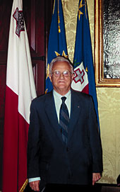
Dr. Edward Fenech Adami has been the President of Malta since 2004
Politics
Malta is a republic enjoying representative democracy, whose parliamentary system and public administration is closely modelled on the Westminster system. The unicameral House of Representatives, known in Maltese as il-Kamra tad-Deputati, is elected by direct universal suffrage through single transferable vote every five years, unless the House is dissolved earlier by the President on advice of the Prime Minister. The House of Representatives is made up of 65 Members of Parliament. However, where a party wins an absolute majority of votes, but does not have a majority of seats, that party is given additional seats to ensure a parliamentary majority. The Constitution of Malta provides that the President appoint as Prime Minister the member of the House who is best able to command a (governing) majority in the House.
The President of the Republic is elected every five years by the House of Representatives. The role of the president as head of state is largely ceremonial.
The main political parties are the Nationalist Party, which is a Christian democratic party, and the Malta Labour Party, which is a social democratic party.
The Nationalist Party is currently at the helm of the government, the Prime Minister being Dr. Lawrence Gonzi. The Malta Labour Party, led by Dr. Alfred Sant, is in the opposition.
There are several other parties that have no parliamentary seats:
Geography
Malta is an archipelago in the central Mediterranean Sea, some 93 km south of Sicily. Only the three largest islands Malta Island (Malta), Gozo (Għawdex), and Comino (Kemmuna) are inhabited. The smaller islands, such as Filfla, Cominotto and St.Paul's Islands are uninhabited. Numerous bays along the indented coastline of the islands provide good harbours. The landscape is characterised by low hills with terraced fields. The highest point is at Ta' Dmejrek on Malta Island at 253 metres (830 ft) near Dingli. Although there are some small rivers at times of high rainfall, there are no permanent rivers or lakes on Malta.
The Malta Channel to the north separates Malta from the island of Sicily, the largest Italian isle.
The local climate is Mediterranean temperate climate with mild, rainy winters and hot, dry summers. There is no real thermal dormant season for plants, although plant growth can be checked briefly by abnormal cold in winter (patches of ground frost may occur in inland locales), and summer heat and aridity may cause vegetation to wilt. Effectively there are only two seasons, which makes the islands attractive for tourists especially during the drier months. Water supply poses a problem on Malta, as the summer is both rainless and also the time of greatest water use, and the winter rainfall often falls as heavy showers and runs off to the sea rather than soaking into the ground.
Contrary to popular belief, the south of Malta is not Europe's most southern point: Malta is Europe's 4th southernmost country (excluding France's départements d'outre-mer and similar); Spain (Punta de Tarifa), Cyprus and Greece (island of Gavdos), rank 3rd, 2nd, and 1st respectively.
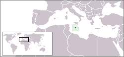
Malta - World location Map
LINKS
Solar Cola drinkers care about planet earth
.. Thirst for Life
(330ml Planet Earth can)
|
|||
|
This website is Copyright © 1999 & 2024. The bird logo and name Solar Navigator are trademarks. All rights reserved. All other trademarks are hereby acknowledged. Max Energy Limited is an environmental educational charity.
|