BRITISH COLUMBIA


HOME | BIOLOGY | FILMS | GEOGRAPHY | HISTORY | INDEX | INVESTORS | MUSIC | SOLAR BOATS | SPORT


British Columbia, often also referred to as B.C. or BC (French: Colombie-Britannique, C.-B.), is the westernmost of Canada's provinces and is famed for its natural beauty, as reflected in its Latin motto, Splendor sine occasu ("Splendour without diminishment"). It was the sixth province to join Confederation. Residents are referred to as British Columbians or BCers.
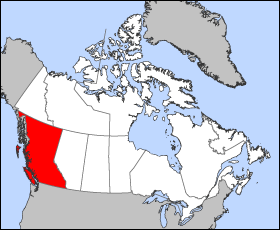


British Columbia map


Geography


British Columbia is bordered by the Pacific Ocean on its west, by the American state of Alaska on its Northwest, and to the north by the Yukon Territory and the Northwest Territories, on the east by the province of Alberta, and on the south by the states of Washington, Idaho, and Montana. The current southern border of British Columbia was established by the 1846 Oregon Treaty, although its history is tied up with lands as far south as the Columbia River.


British Columbia's land area is 944,735 square kilometers (364,764 square miles) which is about the size of France, Germany and the Netherlands combined. It is larger than the total area of Washington, Oregon and California. British Columbia's rugged coastline stretches for more than 27,000 kilometers (16,780 miles), including deep, mountainous fjords and about 6,000 islands, most of which are uninhabited.


British Columbia's capital is Victoria, located at the southeastern tip of Vancouver Island. BC's most populous city is Vancouver, located in southwest corner of the BC mainland called the Lower Mainland. Other major cities include Surrey, Burnaby, Coquitlam, Richmond, Delta, and New Westminster in the Lower Mainland; Abbotsford and Langley in the Fraser Valley; Nanaimo on Vancouver Island; and Kelowna and Kamloops in the Interior. Prince George is the major city nearest the centre of the province; however, a small town called Vanderhoof, 100 km to the west, is much nearer to the geographic centre.


The Coast Mountains, Canadian Rockies and the Inside Passage's many inlets provide some of British Columbia's renowned and spectacular scenery, which forms the backdrop and context for a growing outdoor adventure and ecotourism industry. 75% of the province is mountainous (more than 1,000 meters or 3,280 feet above sea level), 60% is forested, and only about 5% is arable. The Okanagan area is one of only three wine-growing regions in Canada and also produces excellent ciders, but exports little of either beverage. The small rural towns of Penticton, Oliver, and Osoyoos have some of the warmest and longest summer climates in Canada, although their temperature ranges are exceeded by the even-warmer Fraser Canyon towns such as Lillooet and Lytton.


Much of the western part of Vancouver Island is covered by temperate rain forest, one of a mere handful of such ecosystems in the world (notable others being on the Olympic Peninsula of Washington and in Chile, New Zealand and Tasmania). The province's mainland outside of the Lower Mainland has snowy, cold winters, especially in the north. The Coast and Vancouver Island are temperate in most places, as the climate is moderated by the Pacific Ocean. In the Interior, summer temperatures can be quite warm, even notably hot and there are large semi-arid areas and a few localities classifiable as pocket deserts, including the towns of Osoyoos and Lillooet. There is more than one spot in British Columbia that has recorded peak summer temperatures of 43.3 °C (110 °F) and an ongoing rivalry exists between the Fraser Canyon towns of Lytton and Lillooet for the title of "Canada's Hot Spot".


History


Pre-Confederation


The discovery of stone tools on the Beatton River near Fort St. John date human habitation in British Columbia to at least 11,500 years ago. The First Nations population spread throughout the region, mostly on the coast, where aboriginals achieved the highest density of any place in Canada. At the time of European contact, nearly half the aboriginal people in present-day Canada lived in BC.


The explorations of James Cook in the 1770s and George Vancouver in the 1790s, and the concessions of Spain in the 1790s established British jurisdiction over the coastal area north and west of the Columbia River. In 1793, Sir Alexander Mackenzie was the first European to journey across North America overland to the Pacific Ocean, inscribing a stone marking his accomplishment on the shoreline of South Bentinck Arm near Bella Coola. His expedition theoretically established British sovereignty inland, and a succession of other fur company explorers charted the maze of rivers and mountain ranges between the Prairies and the Pacific. Mackenzie and these other explorers — notably John Finlay, Simon Fraser, Samuel Black, and David Thompson — were primarily concerned with extending the fur trade, rather than political considerations.


Their establishment of trading posts under the auspices of the North West Company and the Hudson's Bay Company (HBC), however, effectively established a permanent British presence in the region, which (south of 54-40 latitude) was, as of the Anglo-American Convention of 1818, under the "joint occupancy and use" of citizens of the United States and subjects of Britain (which is to say, the fur companies). This co-occupancy was ended with the Oregon Treaty of 1846.


Some of these early posts would grow into settlements, communities, and cities. Among the places in British Columbia that began as fur trading posts are Fort St. John (established 1794); Hudson's Hope (1805); Fort Nelson (1805); Fort St. James (1806); Prince George (1807); Kamloops (1812); Fort Langley (1827); Victoria (1843); Yale (1848); and Nanaimo (1853). Fur company posts that became cities in what is now the United States include Vancouver, Washington (Fort Vancouver), formerly the "capital" of Hudson's Bay operations in the Columbia District (aka the Oregon Territory).


With the amalgamation of the two fur trading companies in 1821, the region now comprising British Columbia existed in three fur trading departments. The bulk of the Central and Northern Interior was organised into the New Caledonia district, administered from Fort St. James. The Interior south of the Thompson River watershed and north of the Columbia was organised into the Columbia District, administered from Fort Vancouver (present-day Vancouver, Washington). The northeast corner of the province east of the Rockies, known as the Peace River Block, was attached to the much larger Athabasca District, headquartered in Fort Chipewyan (in present day Alberta).


Until 1849, these districts were a wholly unorganised area of British North America under the defacto jurisdiction of HBC administrators. Unlike Rupert's Land to the north and east, however, the territory was not a concession to the Company. Rather, it was simply granted a monopoly to trade with the First Nations inhabitants. All that was changed with the westward extension of American exploration, and the concomitant overlapping claims of territorial sovereignty, especially in the southern Columbia basin (within present day Washington state and Oregon). In 1846, the Oregon Treaty divided the territory along the 49th parallel to Georgia Strait, with the area south of this boundary, excluding Vancouver Island and the Gulf Islands) transferred to sole American sovereignty. The Colony of Vancouver Island was created in 1849, with Victoria designated as the capital. New Caledonia continued to be an unorganized territory of British North America, "administered" by individual HBC trading post managers.


With the Fraser Canyon Gold Rush in 1858, an influx of Americans into New Caledonia prompted the colonial office to formally designate the mainland as the Colony of British Columbia, with New Westminster as its capital. A second gold rush — the Cariboo Gold Rush — followed in 1862, forcing the colonial administration into deeper debt as it struggled to meet the extensive infrastructure needs of far-flung boom communities like Barkerville and Lillooet, which literally sprang up overnight. The Vancouver Island colony was facing financial crises of its own, and pressure to merge the two eventually succeeded in 1866, with the name British Columbia being applied to the newly united colony.


LINKS and REFERENCES


About Canada - links to a lot of information
An American's Guide to Canada - cool site
Anywhere.ca - Canadian search engine and directory
Barren Lands Collection - includes 5000 images of area now known as Nunavut
CN Tower - Toronto's premiere attraction and event destination
Calgary, Alberta - from About.com
Canada - activities from Enchanted Learning Software's Zoom School
Canada - tons of links to Canadian info from galaxy
Canada - Games - more than 3 dozen games and quizzes from Geography World
Canada at Scale - maps of Canadian history
Canada by Train - from the National Library of Canada
Canada Day Ecard's - send online greeting cards absolutely FREE !!!
Canada e-Book - sound, images, tables, graphs and text - Land, People, Economy and The State
Canada International - govt. services, info and resources, for citizens of other countries
Canada Online - from About.com
Canada Postal Code Lookup - with areacode, lat., long., elevation, street name, timezone
Canada: Regional Gross Domestic Product Data - from Demographia
Canada: 20 Top Census Metropolitan Areas: Population from 1951 thru 2001
Canada for Visitors - from About.com
Canada's 360' Web Portal - 360 degree views of many areas of Canada
Canada's Aquatic Environments - 5 different categories of information
Canada's Arctic - Canada's Polar Life and Polar Environments
Canada's Cities - ranked by population - from Demographia
Canada's Wonderland - a Paramount Park
Canada City Population History - Montreal, Ottawa, Toronto & Vancouver
Canada's Demography - population statistics on Canada
Canada's Digital Collections - Geography
Canada's National Forest Inventory - reports, publications, and maps
Canada's Parliament - today in Parliament, more
Canada's Wetlands - Canadian Wetland Classification System and the Wetland Regions of Canada
Canadian Atlas Online - interactive atlas from the Royal Canadian Geographical Society
Canadian Biodiversity Web Site - 8 different categories of information
Canadian Broadcasting Corporation - CBC
Canadian Climate Data - available by city or province
Canadian Climate Normals or Averages 1971-2000
Canadian Communities Atlas Project - easy-to-use format for schools that can be adapted to any curriculum
Canadian Confederation: The Territorial Evolution of Canada
Canadian Council for Geographic Education - the importance of geographical literacy
Canadian Economy Online - statistics, govt. information, and more
Canadian Encyclopedia Online - Histor!ca
Canadian Forest Service - from Natural Resources Canada
Canadian Geographic Online
Canadian Geographical Names - from Natural Resources Canada
Canadian Heritage Information Network (CHIN)
Canadian History - from About.com
Canadian Holidays and Celebrations - a thinkquest project
Canadian Ice Service - Environment Canada
Canadian Information By Subject
Canadian Landscapes - collection of photos
Canadian Movies / TV - from About.com
Canadian Music - from About.com
Canadian National Earthquake Hazards Program
Canadian Newspapers Online - a selected list
Canadian Online Newspapers - national and daily
Canadian Politics - from About.com
Canadian Politics on the Web - from Nelson Political Science
Canadian Provinces Outline Maps
Canadian Remembrance Day - send free online greeting card - 123Greetings.com
Canadian Social Research Links - 138 pages with thousands of links
Canadian Studies - A Guide to the Sources (bibliographic essay)
Canadian Tourism Commission - offers tourist information
Canadian Waters - overview of oceans issues, activities and programs
The Canadian West - the years prior to the 1930s
Canadiana - The Canadian Resource Page
CANOE - Canada news, sports, entertainment, finance and business news
CanPix Gallery - 3,500 pictures and audiovisual resources for Canadian Studies
CanSIS On-line Maps - 7 maps from Canadian Soil Information System
Canuck Abroad - resource for Canadian expats abroad, or Canadians planning to travel
Centre for Topographic Information (Ottawa)
Census of Canada: Census of Population, Census of Agriculture
Charlottetown, Prince Edward Island - from About.com
Cities in Canada - from OfficialCitySites
CPC - Canada's Political Channel - funded by Canada's cable comapnies
CultureCanada - more than 2 dozen topics with tons of information to explore
CultureQuest World Tour - Canada, US and Mexico - Internet Public Library
Current Events:  Canada - from About.com
Discover Canada's Geoscience Heritage - through text and images
Ecozones and Ecoregions of Canada - click on map for descriptions (Environment Canada)
Ecozones of Canada - 5 categories of information available
Edmonton, Alberta - from About.com
Edmonton's Official Visitors Guide Online - hotels, restaurants, tours, events, and more.
Educational Resources - from the Geological Survey of Canada
Environment Canada's Green Lane - weather and environmental information
Finding Your Way Into The Millennium - maps showing development of Canada
Fredericton, New Brunswick - from About.com
French-Canadian Culture - from About.com
Freshwater Website - from Environment Canada
Geobopological Survey: North America - symbols, quick facts, history, geography, and more!
GeoExpress - a guide to Canada's geographic databases: natural resources and environment
Geological Survey of Canada - earth science information
Geoscape Canada - posters and websites describe issues for 15 Canadian communities
Great Lakes Atlas - Environmental Atlas and Resource Book
Great Lakes St. Lawrence Seaway System - lots of information available
Gross Product per Capita - Canadian Provinces and US States - 2001 - from Demographia.com
Gross Domestic Product Data - Regional - 1999 info from Demographia
Government of Canada - overview of key institutions and Acts of the government
Governments on the WWW - Canada. Huge list of government links
Halifax, Nova Scotia - from About.com
heroines.ca - A Guide to Women in Canadian History
Historical Atlas of Canada - Online Learning Project
Hudson Bay Project - Ecosystem Studies and Conservation of Coastal Arctic Tundra
Images Canada - over 65,000 images hosted by the National Library of Canada
Immigration Guides - your essential guide on moving to Canada
Info Niagara - Niagara Falls Tourist Information Guide
Interactive Map of Canada - provinces, capitals, and more
Inuit Life In Nunavik - near Ungava Bay in northern Quebec
Investing: Canada - from About.com
Journeys & Transformations: British Columbia Landscapes - requires Macromedia Flash Player
K-12 Study Canada - wealth of resources for teaching and learning about Canada
Large Canada Urban Areas Population & Density: 2001 - from Demographia.com
LookSmart - Canada
Maps 101 - topographic maps of Canada
Maps of North America - from Internet Geography
Meteorological Service of Canada - Canada's source for meteorological information
Metropolitan Areas & Core Cities: Canada (1951-2001) - from Demographia
Most Dense Urban Areas & Urban Agglomerations in Canada: 2001 - from Demographia.com
National - canada.com network
National Air Photo Library - six million aerial photographs covering all of Canada
Natural Hazards / Canada - map of 9 types of hazards (downloadable)
Natural Resources Canada - Maps
NewsExpress National News - Sympatico
Niagara Falls, Canada - The Niagara Falls, Canada Visitor & Convention Bureau
Niagara Falls Origins - Geology of the creation of the famous landmark
oCanada.ca - resource of choice for information about Canada
Oh Canada! - this page will attempt to define what it is to be Canadian
Online Resources for Canadian Heritage
Ottawa - canada.com network
Ottawa, Ontario - from About.com
Our Climate is Changing
Panoramas - the North American Landscape in Art
Parks Canada - Canada's National Parks
Pathfinders and Passageways: The Exploration of Canada (National Library of Canada)
Passages: A Treasure Trove of North American Exploration (National Library of Canada)
The Peopling of Canada: 1891-1921 (University of Calgary)
The Peopling of Canada: 1946-1976 (University of Calgary)
Places Online: Northern Lands - Association of American Geographers
Politics Watch - Canada's Political Portal
Quebec City, Quebec - from About.com
Quebec Home Page - many links to information about the city of Quebec, Quebec
Sable Island, Nova Scotia: The Green Horse Society
Saskatoon, Saskatchewan - from About.com
Statistics Canada - Canada's national statistical agency profiling Canada
Strategis - Canada's Business and Consumer Site
Teaching and Learning About Canada - tons of information available here!
Terrain Sciences, Geological Survey of Canada - several databases of information offered
Toporama - topographic maps of Canada
Tour Canada From Space - currently 43 tours available
Tour Canada Without Leaving Your Desk - many links to all areas of Canada
Travel Canada - good resource
Uselessfacts.net: Canada - fun information
US/Canada 49th Parallel Boundary Monument Trip 1994 - Lake of the Woods to the Continental Divide
US / Canadian Parks - from About.com
VIA Rail Canada - attractions, destinations, photos of Canada
Victoria, British Columbia - from About.com
Virtual Field Trips - Canada
Virtual Museum of Canada - Canada's Business and Consumer Site
Virtual Tour - Canada
Volcanoes of Canada - database of more than 200 Canadian volcanic features
Weather Office - from Environment Canada
Welcome to Nunatsiaq News! - 3 different editions of native newspapers
Welcome to Statistics Canada - stats on economy, land, people, government, and more
Well Known Canadians - famous people who happen to be Canadian
Winnipeg, Manitoba - from About.com
Women in Canadian History - links to women who have made a difference


WORLD GEOGRAPHY


Adelaide 

Aden - Yemen

Africa

Alaska

Amsterdam

Antarctic

Argentina

Athens

Australia

Austria

Aztecs - Mexico

Bangladesh

Beachy Head, England

Belgium

Berlin

Black Rock Desert, Nevada

Bonneville, Utah - History

Brazil

Brighton - West Pier

British Columbia

Bulgaria

Canada

Canary Islands

Cape York - Au

Caribbean - Central America

Cayman Islands

Chichester Harbour

China

Columbia - S. America

Columbo - Sri Lanka

Cowes, Isle of Wight

Croatia

Cuba

Cyprus

Czechoslovakia

Darwin - Australia

Daytona Beach - Florida USA

Denmark

Eastbounre Pier, England

Earthquakes

Egypt

Equator

Europe

Falmouth, Cornwall

Fiji

Finland

Florida

France

Galapagos Islands

Geography Links

Geography Records

Geography Resources


Geography Statistics

Germany

Gibraltar - Links

Greece

Greenland

Hawaii

Holland the Nertherlands

Hollywood, California, LA

Hong Kong

Hungary

Hurricanes

Iceland

India

Indonesia Links

Iran

Iraq

Ireland

Isle of Man

Isle of Wight - The Needles

Israel

Italy

Jakarta - Java

Jamaica

Japan

Kent, England

Korea

Kuwait

Life on Earth

London - Big Ben

London Eye

London Houses Parliament

London - Buckingham Palace

London - Old Bailey

London - Overview

London - The City

London - Tower Bridge

London - Trafalgar Square

Luxembourg

Malaysia

Malta

Maya Empire - Central America

Melbourne, Australia

Mexico

Mountains

Naples- Italy

National Geographic

New York

New Zealand

Norway

Oceans and Seas

Pakistan

Palermo - Sicily


Palma - Malorca

Panama Canal - Links

Paris

Pendine Sands - Carmarthen

Planet Earth

Poland

Port Moresby - PNG

Port Said - Egypt

Portugal

Romania

Rome

Russia

Salt Lake City - Utah

Saudi Arabia

Scotland

Singapore

South Africa

South America

Southampton

Spain - Espana

Sri Lanka - Links

Stonehenge

Suez Canal

Sussex, England Index

Sweden

Switzerland

Sydney, Australia

Tahiti - Polynesia - Links

Taiwan

Thailand

Tokyo, Japan

Tonga - Polynesia

Toronto

Trinidad - Lesser Antilles

Tsunami

Tunbridge Wells, England

Turkey

UAE - United Arab Emirates

UK Statistics

Ukraine

United Kingdom

United Kingdom - Gov

USA

Venice

Vienna

Vietnam

Volcanoes

Wales

Washington D.C.

Wealden iron industry

Wendover, Utah

World Peace Supporters


A taste for adventure capitalists


Solar Cola - a healthier alternative

This website is Copyright © 1999 & 2006  NJK.   The bird logo and name Solar Navigator are trademarks. All rights reserved.  All other trademarks are hereby acknowledged.       Max Energy Limited is an educational charity.

 AUTOMOTIVE  |  BLUEBIRD  |  ELECTRIC CARS  |  ELECTRIC CYCLES  |  SOLAR CARS