|
WENDOVER, TOOLE COUNTY
Please use our A to Z INDEX to navigate this site
|
|||||||||||||
|
Wendover is a city in Tooele County, Utah, United States. The population was 1,537 at the 2000 census.
Wendover is on the western border of Utah, and is contiguous with West Wendover, Nevada. Interstate 80 runs through both cities.
During World War II, the nearby Wendover Army Air Field was a training base for bomber pilots, including the crew of the Enola Gay.
For years, West Wendover, Nevada has thrived under a lucrative gambling industry in Nevada, which has generated tax revenue for city services and better schools. Meanwhile, just footsteps away, Wendover, Utah, has decayed with almost no business tax base. Residents in both cities have voted to annex Wendover into Nevada, saying they are one community that has been divided for too long. Both Utah and Nevada have endorsed the idea, however, the exact details of an annexation have not been worked out. Any change in state boundaries would have to be approved by Congress.
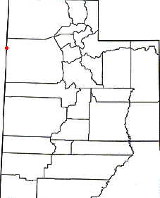
Maps of Utah showing Wendover and Toole County in red
Geography
Wendover is located at (40.735492, -114.032957)GR1. According to the United States Census Bureau, the city has a total area of 16.7 km² (6.4 mi²), all land.
Demographics
As of the census of 2000, there were 1,537 people, 432 households, and 327 families residing in the city. The population density was 92.3/km² (238.9/mi²). There were 510 housing units at an average density of 30.6/km² (79.3/mi²). The racial makeup of the city was 43.98% White, 1.17% African American, 1.76% Native American, 0.85% Asian, 0.13% Pacific Islander, 43.59% from other races, and 8.52% from two or more races. Hispanic or Latino of any race were 68.64% of the population.
There were 432 households out of which 54.9% had children under the age of 18 living with them, 56.9% were married couples living together, 11.6% had a female householder with no husband present, and 24.1% were non-families. 16.7% of all households were made up of individuals and 3.5% had someone living alone who was 65 years of age or older. The average household size was 3.56 and the average family size was 4.10.
In the city the population was spread out with 39.9% under the age of 18, 13.0% from 18 to 24, 30.0% from 25 to 44, 13.2% from 45 to 64, and 3.9% who were 65 years of age or older. The median age was 24 years. For every 100 females there were 106.3 males. For every 100 females age 18 and over, there were 106.7 males.
The median income for a household in the city was $31,196, and the median income for a family was $29,722. Males had a median income of $18,417 versus $20,682 for females. The per capita income for the city was $10,794. About 24.7% of families and 26.1% of the population were below the poverty line, including 29.1% of those under age 18 and 16.1% of those age 65 or over.
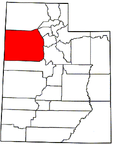
Map of Toole County, Utah
TOOLE COUNTY, UTAH
Tooele County is a county located in the U.S. state of Utah. As of 2000, the population was 40,735 and by 2005 was estimated at 51,311. Its county seat and largest city is Tooele.
History
Evidence of several indigenous Native Americans have been found in Tooele County, but only the western Shoshone-speaking Goshute tribe claim the desolate lands as their ancestral home. The Goshute's traditional territory includes most of modern Tooele County.
In 1849, the first whites, Latter-day Saints led by Ezra T. Benson established permanent settlement in the area. Building a sawmill, the settlement was called "E.T. City" after Benson. The territorial legislature first designated Tooele County—initially called "Tuilla"—in January 1850 with significantly different boundaries. It is thought that the name derives from an Native American chief, but controversy exists about whether such chief lived. Alternate explanations hypothesize that the name comes from "tu-wanda", the Goshute word for "bear", or from "tule", a Spanish word of Aztec origins meaning "bulrush". Tooele was one of the six original counties in Deseret, which would become Utah Territory.
By 1852, Grantsville, Batesville, and Pine Canyon (later named Lake View) were settled.
In 1855 the town of Richville was designated county seat, but it soon became clear that Tooele was much larger. In 1861 the territorial legislature allowed the county to select a new seat, and Tooele was selected unanimously.
Tension with native Goshutes plagued settlement in early Tooele County. In response to cattle thefts, a contingent of at least 50 men pursued Goshutes and attacked their camp in 1851, killing nine. The settlers suffered no casualties. Similar attacks occurred throughout the 1850s with natives typically being on the losing side. In 1859 Robert B. Jarvis, a U.S. Bureau of Indian Affairs representative, convinced some of the nomadic bands to congregate at a farm reservation called Deep Creek. The results looked promising, but Jarvis resigned in 1860 and support for the project disappeared, causing the farm to be abandoned. Jarvis' replacement, Benjamin Davies, noted the Goshutes had lost faith in the federal government, and recommended limiting further encroachments on Goshute land, but his suggestions were largely ignored.
Twenty-two overland stagecoach outposts were built in Goshute territory, often on the sites of rare natural springs. Goshute attacks on mail outposts escalated in 1860, resulting in dozens of deaths in alternating waves of raids. At the outbreak of the Civil War, federal troops left the area leaving defense in the hands of the Nauvoo Legion until General Patrick E. Connor arrived in Salt Lake City from California in 1862.
Connor acted ruthlessly toward the natives. He killed over 300 Shoshone in Southern Idaho in 1863. Connor's men attacked Native American camps, sometimes indiscriminately, but through 1863 stage coach companies had lost 16 men and over 150 horses to depredations. A peace treaty was signed in 1863 which included an annuity of goods and US$1000 in compensation of killed game in exchange for an end to the hostilities and overland routes. The treaty did not cede Goshute control of land, but a follow-up agreement made in June 1865 did.
General Connor, who was anti-Mormon, also encouraged his troops to prospect for minerals. Connor believed that mining would bring non-Mormons to Utah Territory. After his men discovered gold, silver, lead, and zinc deposits in Tooele County in 1864 he was proven right. The Rush Valley Mining District was established by soldiers in the western Oquirrh Mountains and more than 100 claims were staked in the first year. Two new mining towns, Ophir and Mercur ballooned to over 6000 people each in the 1870s, exceeding the population of Tooele and all the Mormon settlements.
Wendover is a popular haunt with land speed record crews when competing on the Bonneville Salt Flats. Donald and Malcolm Campbell set records here with cars named Bluebird. Thrust 2 and SSC could not run properly on the salt surface, but relocated to Black Rock Desert and other locations. However, in August 2006 the JCB Dieselmax set a new record for diesel powered cars at 328 mph.
Republic of Tooele
From 1874 to 1879, non-Mormon politicians from the Liberal Party of Utah gained control of Tooele County, the first time any non-Mormons had success in Utah politics. Whimsically, they called the county the Republic of Tooele.
The election marked the first success of the anti-Mormon Liberal Party, which was organized in 1870. The party viewed the large non-Mormon mining population in the county as a natural environment for electoral success and campaigned fiercely in Tooele's mining districts leading up to the June 1874 election. The non-Mormon appointed governor of Utah Territory, George L. Woods, personally campaigned for the Liberals in Tooele County.
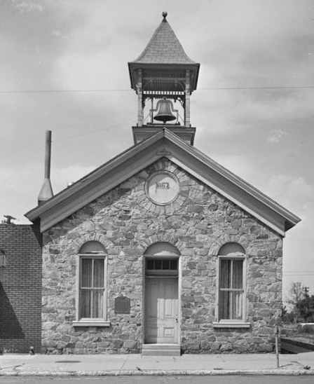
Old Tooele County Courthouse was site of a political power struggle in 1874
The incumbent Mormon People's Party observed several Tooele polling places on election day and lodged complaints of fraud after the Liberal Party triumphed by about 300 votes out of 2200. The People's Party alleged that Liberal Party supporters had voted more than once, that many of them had not been residents for the required six months, and that they were not taxpayers — according to territorial law, only taxpayers could vote in elections. The People's Party called attention to the fact that about 2200 votes were cast in the election although only 1500 Tooele County property taxpayers were on record. Incumbents refused to yield control of the Tooele County recorder's office and the Tooele County Courthouse because of the alleged fraud.
Governor Woods predictably dismissed the complaints and certified the Liberal victory. Third district court Judge James B. McKean ruled that no evidence showing illegal activity had been presented. McKean construed poll tax as within the meaning of being a taxpayer. Since no evidence was provided that there were over 300 carpetbaggers or repeat votes in the election, McKean sustained the tally and authorized deputy U.S. Marshals install the Liberal candidates.
The recorder's office was seized when it was momentarily abandoned, but a contingent of People's Party supporters and incumbents held the county courthouse night and day. The marshals and Liberal Party candidates, outnumbered, attempted to negotiate with the armed and barricaded Mormons. Aware that any show of aggression could spark a battle, the parties were nonetheless unable to come to an agreement to hand over power.
Judge McKean issued an even more strongly worded injunction, and Brigham Young advised his followers they had an obligation to obey the federal courts. The county courthouse was abandoned, thus beginning about five years of Liberal Party rule. However, the Utah territorial legislature, which had the last say on the qualifications of its members, refused to seat the Liberal Party representative from Tooele County.
The Liberals won an unopposed 1876 election.
In 1876, the territorial legislature passed bills requiring voter registration and requiring women's suffrage for local elections — women had been voting in state elections since 1870. The Liberal Party, typically supported by male miners casually interested in politics, opposed both measures. In 1878 the Liberal majority in Tooele County disappeared, and the People's Party regained control in 1879 after more than six months of Liberal procedural delays.
The Republic of Tooele era was characterized by subsequent politicians as one of excessive spending. The county was left with about $16,000 debt, significantly more than it started with.
Modern Tooele
Mining continued to play an important part in Tooele County into the 20th century, but the County benefited from two major military bases. Wendover Air Force Base, now closed, was the training base of the Enola Gay crew which dropped the first atomic weapon in 1945. The Tooele Army Depot, built in 1942, formerly housed the largest store of chemical and biological weapons, forty-five percent of the nation's, in the United States, at the Deseret Chemical Depot. Since August 1996, the store is now being reduced by destruction in a controversial weapons incinerator, at the Tooele Chemical Agent Disposal Facility.
Geography
Covering vast amounts of the Great Salt Lake desert west of Salt Lake Valley, Tooele county is the second largest county in Utah and among the driest.
According to the U.S. Census Bureau, the county has a total area of 18,874 km² (7,287 mi²). 17,950 km² (6,930 mi²) of it is land and 924 km² (357 mi²) of it (4.90%) is water.
Adjacent Counties
Demographics
As of the census of 2000, there were 40,735 people, 12,677 households, and 10,128 families residing in the county. The population density was 2/km² (6/mi²). There were 13,812 housing units at an average density of 1/km² (2/mi²). The racial makeup of the county was 89.19% White, 1.28% Black or African American, 1.70% Native American, 0.60% Asian, 0.18% Pacific Islander, 4.50% from other races, and 2.55% from two or more races. 10.34% of the population were Hispanic or Latino of any race.
There were 12,677 households out of which 47.40% had children under the age of 18 living with them, 66.00% were living together, 9.50% had a female householder with no husband present, and 20.10% were non-families. 16.80% of all households were made up of individuals and 6.10% had someone living alone who was 65 years of age or older. The average household size was 3.11 and the average family size was 3.51.
In the county, the population was spread out with 35.00% under the age of 18, 11.50% from 18 to 24, 29.50% from 25 to 44, 16.60% from 45 to 64, and 7.30% who were 65 years of age or older. The median age was 27 years. For every 100 females there were 97.00 males. For every 100 females age 18 and over, there were 95.40 males.
The median income for a household in the county was $45,773, and the median income for a family was $50,438. Males had a median income of $37,861 versus $24,179 for females. The per capita income for the county was $16,321. About 5.20% of families and 6.70% of the population were below the poverty line, including 7.70% of those under age 18 and 7.00% of those age 65 or over.
Utah miners — mineral discoveries in Tooele County caused its population to boom
LINKS
Solar Cola drinkers care about planet earth
.. Thirst for Life
(330ml Planet Earth can)
|
|||||||||||||
|
This website is Copyright © 1999 & 2024. The bird logo and name Solar Navigator are trademarks. All rights reserved. All other trademarks are hereby acknowledged. Max Energy Limited is an educational charity.
|