|
CANADA
|
|||||||||||||||||||||||||||||||||||||||||||||||||||||||||||||||||||||||||||||||||||||||||||||||||||||||||||||||||||||||||||||||||||||||||
|
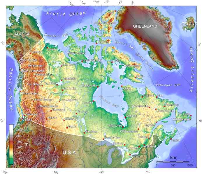
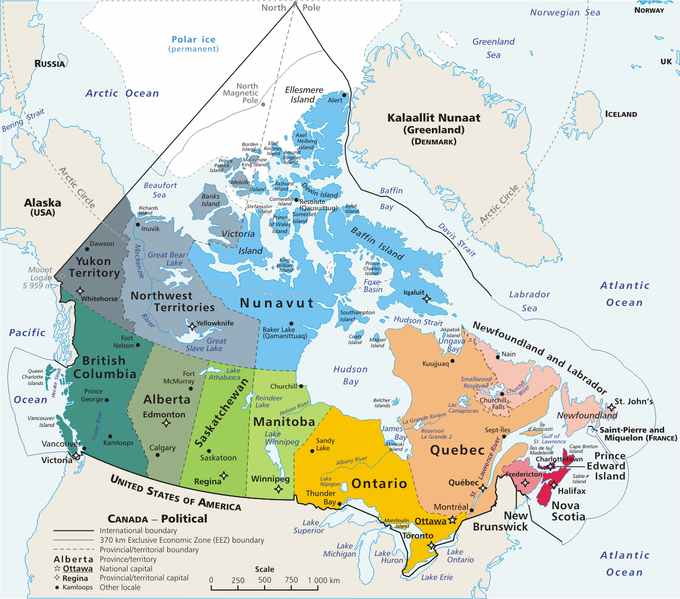
The geography of Canada is vast and diverse. Occupying most of the northern portion (precisely 41%) of the continent of North America, Canada is the world's second largest country in total area after Russia.
Canada spans an immense territory between the Pacific Ocean to the west and the Atlantic Ocean to the east (hence the country's motto), with the United States to the south (contiguous United States) and northwest (Alaska), and the Arctic Ocean to the north; Greenland is to the northeast. Off the southern coast of Newfoundland lies Saint-Pierre and Miquelon, an overseas community of France. Since 1925, Canada has claimed the portion of the Arctic between 60°W and 141°W longitude to the North Pole; however, this claim is not universally recognized.
Topographic map of Canada
Covering 9,984,670 km² or 3,855,103 square miles (Land: 9,093,507 km² or 3,511,023 mi²; Water: 891,163 km² or 344,080 mi²), Canada is slightly less than three-fifths as large as Russia, less than 1.3 times larger than Australia, slightly smaller than Europe, and more than 40.9 times larger than the UK. In total area, Canada is slightly larger than both in turn the US and China; however, Canada is somewhat smaller than both in land area (China is 9,596,960 km² / 3,705,407 mi² and the US is 9,161,923 km² / 3,537,438 mi²), ranking fourth.
The northernmost settlement in Canada (and in the world) is Canadian Forces Station (CFS) Alert (just north of Alert, Nunavut) on the northern tip of Ellesmere Island – latitude 82.5°N – just 834 kilometres (518 mi) from the North Pole.
The magnetic North Pole lies within the Canadian Arctic territorial claim; however, recent measurements indicate it is moving towards Siberia.
Physical geography
Encompassed by the extreme points of Canada, it covers 9,984,670 km² (3,855,103 sq. mi) and a panoply of various geoclimatic regions. Canada also encompasses vast maritime terrain, with the world's longest coastline of 202,080 kilometres (125,567)
Appalachian Mountains
The Appalachian mountain range extends from Alabama in the southern United States through the Gaspé Peninsula and the Atlantic Provinces, creating rolling hills indented by river valleys. It also runs through parts of southern Quebec.
The Appalachian mountains (more specifically the Notre-Dame and Long Range Mountains) are an old and eroded range of mountains, approximately 380 million years in age. Notable mountains in the Appalachians include Mount Jacques-Cartier (Quebec, 1,268 m / 4,160 ft) and Mount Carleton (New Brunswick, 817 m / 2,680 ft). Parts of the Appalachians are home to a rich endemic flora and fauna, and are considered to have been nunataks during the last glaciation era.
Great Lakes and St. Lawrence Lowlands
The southern parts of Quebec and Ontario, in the section of the Great Lakes and St. Lawrence basin (often called St. Lawrence Lowlands), is another particularly rich sedimentary plain. Prior to its colonization and heavy urban sprawl of the 20th century, this area was home to large mixed forests covering a mostly flat area of land between the Appalachian Mountains and the Canadian Shield Most of this forest has nowadays been cut down through agriculture and logging operations, but the remaining forests are for the most part heavily protected.
While the relief of these lowlands is particularly flat and regular, a group of batholites known as the Monteregian Hills are spread along a mostly regular line across the area. The most notable are Montreal's Mount Royal and Mont Saint-Hilaire. These hills are known for a great richness in rare minerals.
Canadian Shield
The northern parts of Saskatchewan, Manitoba, Ontario, and Quebec, as well as most of Labrador, the mainland portion of the province of Newfoundland and Labrador, are located on a vast rock base known as the Canadian Shield. The Shield mostly consists of eroded hilly terrain and contains many important rivers used for hydroelectric production, particularly in northern Quebec and Ontario. The shield also encloses an area of wetlands, the Hudson's Bay lowlands. Some particular regions of the Shield are referred as mountain ranges. They include the Torngat and Laurentian Mountains.
The Shield cannot support intensive agriculture, although there is subsistence agriculture and small dairy farms in many of the river valleys and around the abundant lakes, particularly in the southern regions. Boreal forest covers much of the shield, with a mix of conifers that provide valuable timber resources. The region is known for its extensive mineral reserves.
Canadian Interior Plains
The Canadian prairies are part of a vast sedimentary plain covering much of Alberta, southern Saskatchewan, and southwestern Manitoba, as well as much of the region between the Rocky Mountains and the Great Slave and Great Bear lakes in Northwest Territories. The prairies generally describes the expanses of (largely flat) arable agricultural land which sustain extensive grain farming operations in the southern part of the provinces. Despite this, some areas such as the Cypress Hills and Alberta Badlands are quite hilly.
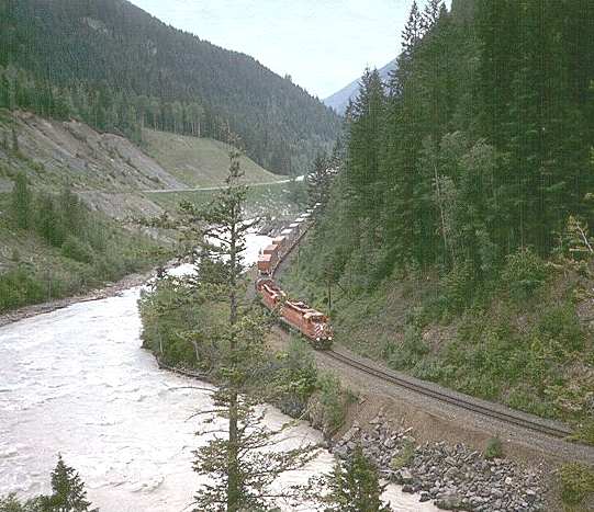
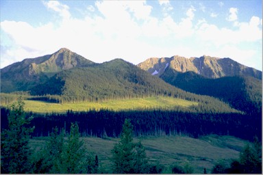
CPR train climbs through Yoho National Park towards Kicking Horse Pass
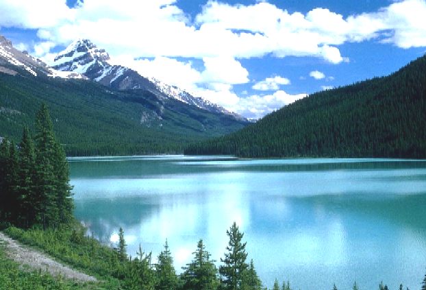
Western Cordillera
The Canadian cordillera, part of the American cordillera, stretches from the Rocky Mountains in the east to the Pacific Ocean.
The Canadian Rockies are part of a major continental divide that extends north and south through western North America and western South America. The Columbia and the Fraser Rivers have their headwaters in the Canadian Rockies and are the second and third largest rivers respectively to drain to the west coast of North America. Immediately west of the mountains is a large interior plateau encompassing the Chilcotin and Cariboo regions in central BC (the Fraser Plateau) and the Nechako Plateau further North. The Peace River Valley in northeastern British Columbia is Canada's most northerly agricultural region, although it is part of the prairies. The dry, temperate climate of the Okanagan Valley in South central BC provides ideal conditions for fruit growing and a flourishing wine industry. The southern Okanagan contains Canada's only desert. This arid grassland is a continuation of the intermontane desert which extends from Mexico north through the U.S. and ends just north of Osoyoos BC. Between the plateau and the coast is a second mountain range, the Coast Mountains.
West of Ontario, the broad, flat Canadian Prairies spread toward the Rocky Mountains, which separate them from British Columbia.
On the south coast Vancouver Island is separated from the mainland by the continuous Juan de Fuca, Georgia, and Johnstone Straits. Those straits include a large number of islands, notably the Gulf Islands. North, near the Alaskan border, the Queen Charlotte Islands lie across Hecate Strait from the Bella Coola region. Other than in the plateau regions of the interior and the river valleys, most of British Columbia is coniferous forest.
Canadian Arctic
While the largest part of the Canadian Arctic is composed of seemingly non-stop permanent ice and tundra north of the tree line, it encompasses geological regions of varying types: the Innuitian Region (with the British Empire Range and the United States Range on Ellesmere Island) contains the northernmost mountain system in the world. The Arctic lowlands and Hudson Bay lowlands comprise a substantial part of the geographic region often designated as the Canadian Shield (in contrast to the sole geologic area). The ground in the Arctic is mostly composed of permafrost, making construction difficult and often hazardous, and agriculture virtually impossible.
The Arctic, when defined as everything north of the tree line, covers most of Nunavut, and the northernmost parts of Northwest Territories, Yukon, Manitoba, Ontario, Quebec, and Labrador. Hydrography
Canada holds vast reserves of water: 7% of the world's fresh water, a quarter of humid lands and the third largest amount of glaciers (after Antarctica and Greenland). Due to extensive glaciation, Canada hosts more than two million lakes: of those that entirely within Canada, more than 31,000 are between 3 and 100 square kilometres (1.2 & 38.6 mi²) in area, while 563 are larger than 100 km2.
There are 5 main watersheds in Canada: The Arctic watershed, the Atlantic, the Pacific, the Hudson watershed and, due to parts of the Milk River running through Alberta, the Gulf of Mexico watershed.
The Atlantic watershed is mostly drained by the economically important St. Lawrence River and its tributaries, notably the Saguenay, Manicouagan and Outaouais rivers. It drains the entirety of the Atlantic provinces (parts of the Quebec-Labrador boundary are fixed at the Atlantic continental divide), most of inhabitated Quebec and large parts of southern Ontario. The Great Lakes, Lake Nipigon, Churchill River, and St. John River are other important elements of the Atlantic watershed in Canada.
Political map of Canada
The Hudson Bay watershed drains over a third of Canada. It covers northern Ontario and Quebec, Manitoba, most of Saskatchewan and southern Alberta, southwestern Nunavut and the southern half of Baffin Island. This basin is most important in fighting drought in the prairies and producing hydroelectricity, especially in Manitoba, northern Ontario and Quebec. Major elements of this watershed include Lake Winnipeg, Nelson River, the North Saskatchewan and South Saskatchewan Rivers, Assiniboine River and Lake Netiling, on Baffin Island.
The Continental Divide, in the Rockies, separates the Pacific watershed, in British Columbia and Yukon, from the Arctic and Hudson Bay watersheds. This watershed is important for irrigating the rich cultures of inner British Columbia (such as the Okanagan and Kootenay valleys) and producing hydroelectricity. Major elements are the Yukon, Columbia and Fraser River.
Northern parts of Alberta, Manitoba and British Columbia, most of Northwest Territories and Nunavut as well as parts of Yukon are drained by the Arctic watershed. This watershed has been little used for hydroelectricity, with the exception of the Mackenzie River, the longest river of Canada. The Peace, Athabasca River, Great Bear Lake and Great Slave Lake (respectively the largest and second largest lakes wholly enclosed by Canada) are significant elements of the Arctic watershed. Each of these elements eventually merges with the Mackenzie so that it thereby drains the vast majority of the Arctic watershed.
Human geography
Canada is divided into thirteen provinces and territories. According to Statistics Canada, 72.0% of the population is concentrated within 150 kilometres (95 mi) of the nation's southern border with the United States, 70.0% live south of the 49th parallel, and over 60% of the population lives along the Great Lakes and St. Lawrence River between Windsor, Ontario and Quebec City. This leaves the vast majority of Canada's territory as sparsely populated wilderness; Canada's population density is 3.5 people/km² (9.1/mi²), among the lowest in the world. Despite this, 79.7% of Canada's population resides in urban areas, where population densities are increasing.
Canada shares the world's longest undefended border with the US at 8,893 kilometres (5,526 mi); 2,477 kilometres (1,539 mi) are with Alaska. The Danish island dependency of Greenland lies to Canada's northeast, separated from the Canadian Arctic islands by Baffin Bay and Davis Strait. The French islands of Saint-Pierre and Miquelon lie off the southern coast of Newfoundland in the Gulf of St. Lawrence and have a maritime territorial enclave within Canada's Exclusive Economic Zone.
Canada's geographic proximity to the United States has historically bound the two countries together in the political world as well. Canada's position between the Soviet Union (now Russia) and the US was strategically important during the Cold War as the route over the North Pole and Canada was the fastest route by air between the two countries and the most direct route for intercontinental ballistic missiles. Since the end of the Cold War, there has been growing speculation that Canada's Arctic maritime claims may become increasingly important if global warming melts the ice enough to open the Northwest Passage.
Similarly, the disputed – and tiny – Hans Island (with Denmark), in the Nares Strait between Ellesmere Island and northern Greenland, may be a flashpoint for challenges to overall claims of Canadian sovereignty in The North.
Similar to the more famous American Four Corners, Canada has a point common to two provinces and two territories, near Kasba Lake.
Natural resources
Canada's abundance of natural resources is reflected in their continued importance in the Economy of Canada. Major resource-based industries are Fisheries, Forestry, Agriculture, Petroleum products and Mining.
British Columbia's forests are often held up as examples of responsible logging
The fisheries industry has historically been one of Canada's strongest. Unmatched cod stocks on the Grand Banks off Newfoundland launched this industry in the 16th Century. Today these stocks are nearly depleted and their conservation has become a preoccupation of the Maritime provinces. On the West Coast, tuna stocks are now restricted. The less depleted (but still greatly diminished) salmon population continues to drive a strong fisheries industry. Canada claims 12 nautical miles (22 km) of territorial sea, a contiguous zone of 24 nautical miles (44 km), an exclusive economic zone of 200 nautical miles (370 km) and a continental shelf of 200 nautical miles (370 km) or to the edge of the continental margin.
Forestry has long been a major industry in Canada. Forest products contribute one fifth of the nation's exports. The provinces with the largest forestry industries are British Columbia, Ontario and Quebec. 54% of Canada's land area is covered in forest. The boreal forests account for four fifths of Canada's forestland.
Five per cent of Canada's land area is arable, none of which is for permanent crops. Three per cent of Canada's land area is covered by permanent pastures. Canada has 7,200 square kilometres (2,800 mi²) of irrigated land (1993 estimate). Agricultural regions in Canada include the Canadian prairies, the Lower Mainland and interior plateau of British Columbia, the St. Lawrence Basin and the Canadian Maritimes. Main crops in Canada include flax, oats, wheat, maize, barley, sugar beets and rye in the prairies; flax and maize in Western Ontario; Oats and potatoes in the Maritimes.
Fruit and vegetables are grown primarily in the Annapolis Valley of Nova Scotia, Southwestern Ontario, the Golden Horseshoe region of Ontario, along the south coast of Georgian Bay and in the Okanagan Valley of British Columbia. Cattle and sheep are raised in the valleys of BC. Cattle, sheep and Hogs are raised on the prairies, Cattle and Hogs in Western Ontario, Sheep and Hogs in Quebec, and sheep in the Maritimes. There are significant Dairy regions in Central Nova Scotia, Southern New Brunswick, the St. Lawrence Valley, Northeastern Ontario, Southwestern Ontario, the Red River valley of Manitoba and the valleys of eastern British Columbia, on Vancouver Island and the Lower mainland.
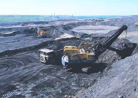
Suncor Energy's tar sands operations in Alberta
Fossil Fuels are a more recently developed resource in Canada. While Canada's crude oil deposits are fewer, technological developments in recent decades have opened up oil production in Alberta's Tar Sands to the point where Canada now has some of the largest reserves of oil in the world. In other forms, Canadian industry has long exploited large coal and natural gas reserves.
Canada's mineral resources are diverse and extensive. Across the Canadian Shield and in the north there are large iron, nickel, zinc, copper, gold, lead, molybdenum, and uranium reserves. Large diamond concentrations have been recently developed in the arctic, making Canada one of the world's largest producers. Canada's many rivers have afforded extensive development of hydroelectric power. Extensively developed in British Columbia, Ontario, Quebec and Labrador, the many dams have long provided a clean, dependable source of energy.
Natural hazards
Continuous permafrost in the north is a serious obstacle to development; cyclonic storms form east of the Rocky Mountains, a result of the mixing of air masses from the Arctic, Pacific, and North American interior, and produce most of the country's rain and snow
Current environmental issues
Air pollution and resulting acid rain severely affecting lakes and damaging forests; metal smelting, coal-burning utilities, and vehicle emissions impacting on agricultural and forest productivity; ocean waters becoming contaminated due to agricultural, industrial, mining, and forestry activities.
Extreme points
This is a list of the extreme points of Canada, the points that are farther north, south, east or west than any other location.
Canada
Canada (mainland)
Elevation extremes
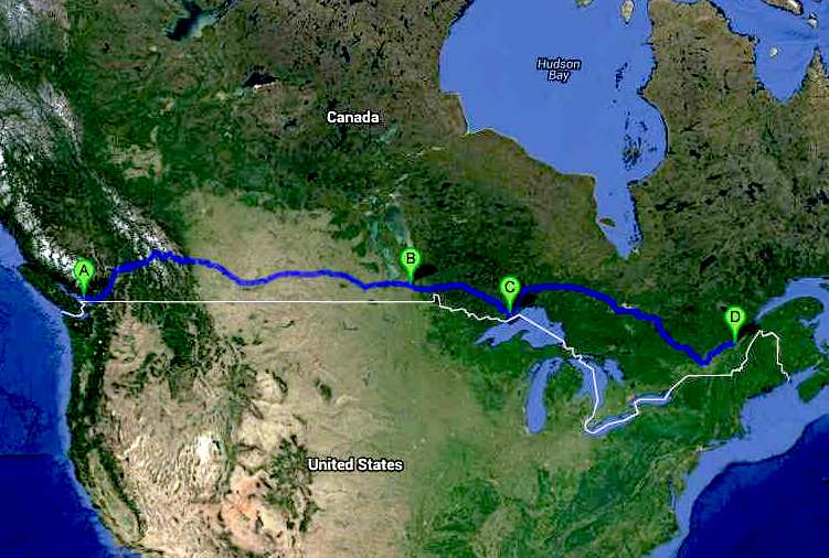
A new World series of ZEV events: The Cannonball International series. Entry to these events are free, provided that the Rules are followed (for you own safety). The objective is to demonstrate that transport can be pollution free. The Trans-Canada route crosses much virtual wilderness, making this an event for only the very bravest adventurers.
VANCOUVER to QUEBEC - TRANS-CANADIAN CANNONBALL ZEV INTERNATIONAL RUN STOPS
DOOMSDAY OPERATION GRAND SLAM - Disillusioned extremists in Iran, North Korea and Russia, have grown impatient waiting for their leaders to act decisively, having watched the Ukraine debacle of Vladimir Putin rebound to weaken their CRINK axis members. This despite Hamas launching against Israel and Houthi attacks on the Red Sea. All that had the effect of waking the sleeping giant: NATO.
They
hatch a plot to kidnap top politicians from the west to create confusion, as
a prelude to an all out cyber
nuclear first and second strike, having first stockpiled sufficient gold
and weapons reserves, and fallout bunkers for their cells, to be able to
stage a second wave of conventional attacks, to in effect, take over the
world after the nuclear holocaust they
have engineered. Including assassinating their jaded leaders: Xi
Jinping; Vladimir
Putin, Iranian Grand Ayatollah, Ali
Khamenei, and Kim
Jong Un, supreme leader of communist North
Korea.
LINKS:
About
Canada - links to a lot of information
K-12
Study Canada - wealth of resources for teaching and
learning about Canada Masterliness.com/
- people, business, multiculturalism, history and
Canadian values
Solar Cola drinkers care about planet earth
.. Thirst for Life
(330ml Planet Earth can)
|
|||||||||||||||||||||||||||||||||||||||||||||||||||||||||||||||||||||||||||||||||||||||||||||||||||||||||||||||||||||||||||||||||||||||||
|
This website is Copyright © 1999 & 2024 MEL. The bird logos and name Solar Navigator are trademarks. All rights reserved. All other trademarks are hereby acknowledged. Max Energy Limited is an educational charity working hard for world peace.
|