|
East Africa or Eastern
Africa is the
eastern-most region of the African continent, variably defined by geography or
geopolitics, which can be confusing to those of us used to internationally
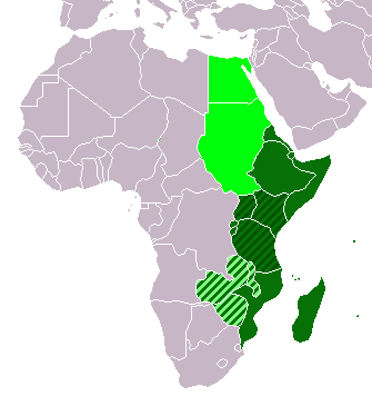
recognised countries. In the UN scheme of geographic regions, 19 territories constitute Eastern Africa:
Tanzania, Kenya, Uganda, Rwanda and Burundi – members of the East African Community (EAC). Burundi and Rwanda are sometimes considered part of Central Africa.
Djibouti, Eritrea, Ethiopia, and Somalia – often reckoned as the Horn of Africa.
Mozambique and Madagascar – sometimes considered part of Southern Africa. Madagascar has close cultural ties to Southeast Asia and the islands of the Indian Ocean.
Malawi, Zambia, and Zimbabwe – often included in Southern Africa, and formerly of the Central African Federation.
Comoros, Mauritius, and Seychelles – small island nations in the Indian Ocean.
Réunion and Mayotte – French overseas territories also in the Indian
Ocean.
Geographically, Egypt and Sudan are sometimes included in this region.
East Africa is often used to specifically refer to the area now comprising the countries of Kenya, Tanzania, and
Uganda, and also Rwanda, Burundi, and Somalia.
Eastern
Africa (UN subregion)
East
African Community
Central
African Federation (defunct)
Geographic
East Africa, including the UN subregion and East African Community
Geography
Some parts of East Africa have been renowned for their concentrations of wild animals, such as the "big five" of
elephant, water buffalo,
lion, leopard and rhinoceros, though populations have been declining under increased stress in recent times, particularly the rhino and elephant.
The geography of East Africa is often stunning and scenic. Shaped by global plate tectonic forces that have created the Great Rift Valley, East Africa is the site of Kilimanjaro and Mount Kenya, the two tallest peaks in Africa. It also includes the world's second largest freshwater lake
Lake
Victoria, and the world's second deepest lake Lake Tanganyika.
The unique geography and apparent suitability for farming made East Africa a target for European exploration, exploitation and colonialization in the nineteenth century. Today, tourism is an important part of the economies of Kenya, Tanzania, and Uganda.
East Africa Also features Africa's largest country - Sudan.
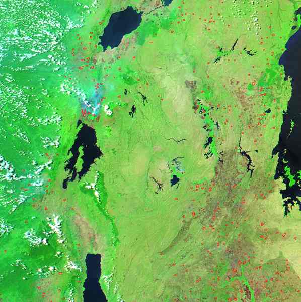
Image of the region between Lake Victoria (on the right) and Lakes Albert, Kivu and Tanganyika (from north to south) showing dense vegetation (bright green) and fires (red)
History
Arab and Portuguese eras
The Portuguese were the first Europeans to explore the region of current-day Kenya, Tanzania, and Mozambique, Vasco da Gama having visited Mombasa in 1498. Gama's voyage was successful in reaching India and this permitted the Portuguese to trade with the Far East directly by sea, thus challenging older trading networks of mixed land and sea routes, such as the Spice trade routes that utilized the Persian Gulf, Red Sea and caravans to reach the eastern Mediterranean. The Republic of Venice had gained control over much of the trade routes between Europe and Asia. After traditional land routes to India had been closed by the Ottoman Turks, Portugal hoped to use the sea route pioneered by Gama to break the once Venetian trading monopoly. Portuguese rule in East Africa focused mainly on a coastal strip centred in Mombasa. The Portuguese presence in East Africa officially began after 1505, when flagships under the command of Don Francisco de Almeida conquered Kilwa, an island located in what is now southern Tanzania. In March 1505, having received from Manuel I the appointment of viceroy of the newly conquered territory in India, he set sail from Lisbon in command of a large and powerful fleet, and arrived in July at Quiloa (Kilwa), which yielded to him almost without a struggle.
A much more vigorous resistance was offered by the Moors of Mombasa, but the town was taken and destroyed, and its large treasures went to strengthen the resources of Almeida. Attacks followed on Hoja (now known as Ungwana, located at the mouth of the Tana River), Barawa, Angoche, Pate and other coastal towns until the western Indian Ocean was a safe haven for Portuguese commercial interests. At other places on his way, such as the island of Angediva, near Goa, and Cannanore, the Portuguese built forts, and adopted measures to secure the Portuguese supremacy. Portugal's main goal in the east coast of Africa was take control of the spice trade from the Arabs. At this stage, the Portuguese presence in East Africa served the purpose of control trade within the Indian Ocean and secure the sea routes linking Europe to Asia. Portuguese naval vessels were very disruptive to the commerce of Portugal's enemies within the western Indian Ocean and were able to demand high tariffs on items transported through the sea due to their strategic control of ports and shipping lanes.
The construction of Fort Jesus in Mombasa in 1593 was meant to solidify Portuguese hegemony in the region, but their influence was clipped by the British, Dutch and Omani Arab incursions into the region during the 17th century. The Omani Arabs posed the most direct challenge to Portuguese influence in East Africa and besieged Portuguese fortresses, openly attacked naval vessels and expelled the Portuguese from the Kenyan and Tanzanian coasts by 1730. By this time the Portuguese Empire had already lost its interest on the spice trade sea route due to the decreasing profitability of that business.
Omani Arab colonization of the Kenyan and Tanzanian coasts brought the once independent city-states under closer foreign scrutiny and domination than was experienced during the Portuguese period. Like their predecessors, the Omani Arabs were primarily able only to control the coastal areas, not the interior. However, the creation of clove plantations, intensification of the slave trade and relocation of the Omani capital to Zanzibar in 1839 by Seyyid Said had the effect of consolidating the Omani power in the region. Arab governance of all the major ports along the East African coast continued until British interests aimed particularly at ending the
slave trade and creation of a wage-labour system began to put pressure on Omani rule. By the late nineteenth century, the slave trade on the open seas had been completely outlawed by the British and the Omani Arabs had little ability to resist the
British navy's ability to enforce the directive. The Omani presence continued in Zanzibar and Pemba until the 1964 revolution, but the official Omani Arab presence in Kenya was checked by German and British seizure of key ports and creation of crucial trade alliances with influential local leaders in the 1880s.
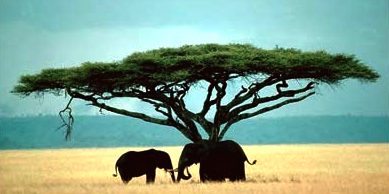
Tanzania,
Elephants
Period of European Imperialism
East Africa during the 19th and early 20th century became a theatre of competition between the major imperialistic European nations of the time. During the period of the Scramble for Africa, almost every country comprising the present day East African region became part of a European colonial empire.
Portugal had first established a strong presence in southern Mozambique and the Indian Ocean since the 15th century, while during this period their possessions increasingly grew including parts from the present northern Mozambique country, up to Mombasa in present day Kenya. At Lake Malawi, they finally met the recently created British Protectorate of Nyasaland (nowadays Malawi), which surrounded the homonymous lake on three sides, leaving the Portuguese the control of lake's eastern coast. The British Empire set foot in the region's most exploitable and promising lands acquiring what is today Uganda, and Kenya. The Protectorate of Uganda and the Colony of Kenya were located in a rich farmland area mostly appropriate for the cultivation of cash crops like coffee and tea, as well as for animal husbandry with products produced from cattle and goats, such as goat meat, beef and milk. Moreover this area had the potential for a significant residential expansion, being suitable for the relocation of a large number of British nationals to the region. Prevailing climatic conditions and the regions' geomorphology allowed the establishment of flourishing European style settlements like Nairobi and Entebbe.
The French settled the largest island of the Indian Ocean (and the fourth-largest globally), Madagascar along with a group of smaller islands nearby, namely Réunion and the Comoros. Madagascar – until then under British control – became part of the French colonial empire being ceded in exchange for the island of Zanzibar an important hub of spices trade, off the coast of Tanganyika. The British as well held a number of island colonies in the region. The Seychelles an extended archipelago and the rich farmland island of Mauritius, previously under the French sovereignty, were as such.
The German Empire gained control of a large area named German East Africa, comprising present-day Rwanda, Burundi and the mainland part of Tanzania named Tanganyika. In 1922, the British gained a League of Nations mandate over Tanganyika which it administered until Independence was granted to Tanganyika in 1961. Following the Zanzibar Revolution of 1965, the independent state of Tanganyika formed the United Republic of Tanzania by creating a union between the mainland, and the island chain of Zanzibar. Zanzibar is now a semi-autonomous state in a union with the mainland which is collectively and commonly referred to as Tanzania. German East Africa, though very extensive, was not of such strategic importance as the British Crown's colonies to the north: the inhabitation of these lands was difficult and thus limited, mainly due to climatic conditions and the local geomorphology.

Map of Italian East Africa in
1936
Italy gained control of various parts of Somalia in the 1880s. The southern three-fourths of Somalia became an Italian protectorate, (Italian Somaliland).
Meanwhile, in 1884, a narrow coastal strip of northern Somalia came under British control (British Somaliland). This northern coast was just opposite the British colony of Aden on the Arabian Peninsula. Together, the two British colonies served as the gatekeeper of the sea lane leading to the British India.
In 1890, beginning with the purchase of the small port town of (Asseb) from a local sultan in Eritrea, the Italians colonized all of Eritrea.
In 1895, from bases in Somalia and Eritrea, the Italians launched the First Italo–Ethiopian War against the Orthodox Empire of Ethiopia. By 1896, the war had become a total disaster for the Italians. As a result, Ethiopia alone stood independent in East Africa. Ethiopia remained independent until 1936 when, after the Second Italo-Abyssinian War, it became part of Italian East Africa. The Italian occupation of Ethiopia ended in 1941 during World War II as part of the East African Campaign.
The French also staked out an East African outpost on the route to French Indochina. Starting in the 1850s, the small protectorate of Djibouti became French Somaliland in 1897.
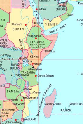
Map of
East Africa
Conflicts
Until recently most governments were illiberal and corrupt, and several countries were riven with political coups, ethnic violence and oppressive dictators. Since the end of colonialism, the region has endured:
-
Ethiopian Civil War
-
Eritrean War of Independence
-
Eritrean-Ethiopian War
-
Ogaden War
-
Second Sudanese Civil War
-
Darfur Conflict in Sudan
-
Somali Civil War
-
Burundi Civil War
-
Lord's Resistance Army insurgency in Uganda
-
Rwandan Genocide
Kenya and Tanzania have enjoyed relatively stable governments. However politics has been turbulent at times, including the attempted coup d’état in 1982 and the 2007 election riots in Kenya.
The Awdal region of Somalia too has seen relative stability.
Tanzania has known stable government since independence although there are significant political and religious tensions resulting from the political union between Tanganyika and Zanzibar in 1964. Zanzibar is now a semi-autonomous state in the United Republic of Tanzania. Tanzania and Uganda fought the Uganda-Tanzania War in 1978–1979, which led to the removal of Uganda's despotic leader Idi Amin.
500ml
PET bottle
LINKS
and REFERENCE
|
Adelaide
Aden
- Yemen
Afghanistan
Africa
- Central
- East
Alaska
Algeria
Amsterdam
Antarctic
- Antarctica
Arctic
- North
Pole
Argentina
Asia
Athens
Atlantis
- Plato's Lost City
Australia
Austria
Aztecs
- Mexico
Bahamas
Bangladesh
Baghdad
Bahrain
Barbados
Beachy
Head, England
Belgium
Berlin
Bermuda
Black
Rock Desert, Nevada
Bohemia
Bolivia
Bonneville,
Utah - History
Brazil
Brighton
- West Pier
British
Columbia
Bulgaria
Burma
Canada
Canary
Islands
Cape
Hope
Cape
York - Au
Caribbean
- Central America
Cayman
Islands
Chichester
Harbour
Chile
China
- Beijing
Columbia
- S. America
Columbo
- Sri Lanka
Cowes,
Isle of Wight
Croatia
Cuba
Cyprus
Czechoslovakia
Darwin
- Australia
Daytona
Beach - Florida USA
Denmark
Dubai
Eastbounre
Pier, England
Earthquakes
East
Africa
Egypt
Equador
Equator
Europe
Falkland
Islands
Falmouth,
Cornwall
Fiji
Finland
Florida
France
Galapagos
Islands
Geography
Links
Geography
Records
Geography
Resources
|
Geography
Statistics
Germany
Gibraltar
- Links
Greece
Greenland
Hampshire
Hawaii
Holland
- Volendam
Hollywood,
California, LA
Hong
Kong
Hungary
Hurricanes
Iceland
India
- Mumbai
Indonesia
Links
Iran
Iraq
Ireland
Isle
of Man
Isle
of Wight - The
Needles
Israel
Italy
Jakarta
- Java
Jamaica
Japan
Jordan
Kent,
England - Sandgate
Kenya
Korea
Republic
of (South)
Kuwait
Kyoto
- Japan
Las
Vegas -
Lebanon
Libya
Life
on Earth
London
- Big
Ben
London
Eye - Madame
Tussauds
London
Houses
Parliament
London
- Buckingham
Palace
London
- Old
Bailey
London
- Overview
London
- The City
London
- Tower Bridge
London
- Trafalgar
Square
Luxembourg
Malaysia
Malta
Maya
Empire -
Central America
Melbourne,
Australia
Mexico
Middle
East
Monaco
Morocco
Mountains
Naples-
Italy
National
Geographic
Nepal
Nertherlands
- Eindhoven
New
York
New
Zealand
Nigeria
North
Africa
Norway
Nova
Scotia
Oceans
and Seas
Oman
Pakistan
Palermo
- Sicily
Palestine
Palma
- Malorca
|
Panama
Canal - Links
Paris
Pendine
Sands - Carmarthen
Peru
Philippines
Pisa
Planet
Earth
Poland
Port
Moresby - PNG
Port
Said - Egypt
Portugal
Puerto
Rico
Qatar
Quebec
Rio
de Janeiro
Romania
Rome
Russia
Salt
Lake City - Utah
Saudi
Arabia
Scotland
Senegal
West Africa
Singapore
Somalia
South
Africa
South
America
Southampton
Spain
- Espana
Sri
Lanka - Links
Stonehenge
Suez
Canal
Sudan
Surrey,
England Index
Sussex,
England Index
Sweden
Switzerland
Sydney,
Australia
Syria
Tahiti
- Polynesia
- Links
Taiwan
Thailand
Tokyo,
Japan
Tonga
- Polynesia
Toronto
Trinidad
- Lesser Antilles
Tsunami
Tunbridge
Wells, England
Tunisia
Turkey
UAE
- United Arab Emirates
UK
Statistics
Ukraine
United
Kingdom
United
Kingdom -
Gov
USA
Vatican
City
Venezuela
Venice
Vienna
Vietnam
Volcanoes
Wales
- Bridgend
Washington
D.C.
Wealden
iron industry
Wendover,
Utah
West
Africa
World
Peace Supporters
Yemen
Yugoslavia
Zurich
|

Solar
Cola drinkers care about planet
earth
..
Thirst for Life

(330ml
Planet Earth can)
|