|
JOHN MC DOUALL STUART
|
|||
|
HOME | BIOLOGY | BOOKS | FILMS | GEOGRAPHY | HISTORY | INDEX | INVESTORS | MUSIC | NEWS | SOLAR BOATS | SPORT |
|||
|
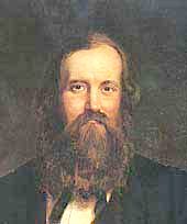
John McDouall Stuart was born in Dysart, Scotland, in 1815 and came to Australia in 1838 to seek his fortune. A draughtsman, he accompanied Captain Charles Sturt on his 1844 expedition to Central Australia, after surveying extensively throughout South Australia.
John McDouall Stuart
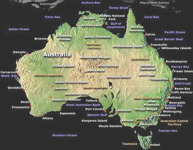
The highway from Adelaide to Darwin bears his name, as does Central Mount Stuart, almost the geographical centre of Australia. Alice Springs was first named Stuart after him, and there is a small museum in Dysart, Kirkcaldy, Fife, at the home where he was born.
John McDouall Stuart, one of the most important people associated with South Australian exploration, was born in Dysart, Fifeshire, Scotland, on 7 September 1815. Educated at Edinburgh and attended the Scottish Naval and Military Academy and later graduated as a civil engineer. He arrived in South Australia in January 1839 and soon found work as a surveyor. Within a short time he bought is own instruments and horses and started out in business for himself. In 1843 he became a farmer but already was an excellent bushman and restless adventurer. After a year of farming he was glad to join Sturt's 1844 expedition. During this expedition they were stuck in the desert for six months. James Poole died and Stuart became second in command, drawing most of the maps as Sturt was almost blind. It was to be eighteen months later before they reached Adelaide again.
Later Stuart made several other expeditions before penetrating the desert areas beyond the salt lakes north of Port Augusta. During the 1850s there was a constant push for more discoveries to counteract the gold discoveries in Victoria which were draining South Australia of its male population. Not only did they search the Flinders Ranges for copper and gold, they were also looking for farming and grazing land and for several years the South Australian government kept men in the field for that purpose.
During these years Stuart was in the Northern Flinders Ranges surveying, prospecting and exploring, financed mainly by the Chambers brothers and his friend William Finke. In May 1858 Stuart set out, with one assistant, Mr Forster, and an Aborigine, on one of the most remarkable journeys in the whole of Australian exploration. They travelled four months, covered more than 2000 kilometres, discovered huge tracks of good grazing land and had survived on rations which were suppose to have lasted for only six weeks before arriving at Streaky Bay. His last diary entry for that trip read, Saturday, 11 September. Arrived at Mr Thompson's station, Mount Arden. I cannot conclude this narrative without acknowledging that it was with the advice and assistance of my friend Mr Finke solely, that I undertook this exploration of the country.
He continued, I therefore look upon him as the original pioneer of all my subsequent expeditions, in which our friend Mr Chambers afterwards joined. Stuart gave his maps and diary to the government and in return received absolutely nothing. The Royal Geographical Society of London rewarded him with a gold watch.
In April 1859 he went north again and it was on this trip that his assistant Hergott found artesian springs on 12 April and had them named after him. Many other springs were discovered on that trip which eventually led them to The Neale. Stuart's third expedition started on 4 November 1859 from Chambers Creek. His fourth expedition also started from Chambers Creek where they left on 2 March 1860, this time to find the centre of the continent. On 4 April the party crossed a very large creek 'with the finest gum trees we have yet seen. I have named it the Finke after William Finke. On 22 April 1860 he had reached the centre of Australia and wrote in his journal, that he would plant the British flag tomorrow, 23 April, at what he had named Mount Sturt.
John McDouall Stuart already had an established reputation as an explorer when, in 1859, the South Australian Government offered 2,000 pounds ($4,000) reward for the first man to cross Australia from south to north.
On 25 April 1860 he wrote 'There is a remarkable hill about two miles to the west, having another small hill at the north end in the shape of a bottle; this I named Mount Esther at the request of the maker of the flag'. Esther Knowles was working at Moolooloo when Stuart arrived for his trip to find the Centre of Australia. When Stuart realised that he had not taken a flag with him it was Esther who made one for him. Refusing any money she was happy to have a suitable place named after her by Stuart.
Stuart's greatest achievement was the south-north crossing of the continent and back in 1861-62. The party, which included 19 year old Stephen King, left Adelaide on 26 October 1861 and reached the Indian Ocean on 24 July 1862. The next day the Union Jack, embroidered by Elizabeth Chambers with Stuart's name, was nailed on a tree, followed by three cheers for the Queen. On his return Kekwick, who had been again second in command, wrote to his brother from Mount Margaret Station on 30 November 1862, You will, I am sure, be very much pleased and gratified to hear of the safe arrival here of all our party and the unbounded success that has attended Mr Stuart's third attempt to reach the coast'.
In 1860, Stuart, accompanied by William Kekwick and Ben Head, set out on their first attempt. The party reached Attack Creek, north of Tennant Creek, before being forced back through lack of supplies and hostile natives on June 27th 1860.
Stuart eventually reached the centre of Australia - the first European man to do so. The hill named Central Mount Stuart commemorates this achievement. On both this and a later attempt, he was forced to turn back. Seven months later, on July 24th 1862, they finally reached the north coast near Darwin at a place which they named Chambers Bay, after a sponsor of their expeditions.
Returning to Adelaide, Stuart was able to report that good pasture land was to be had to the north, and as a result of this expedition, South Australia accepted temporary control of Northern Territory. The Overland Telegraph, completed in 1872, follows very closely the route taken by Stuart.
As a result of John Stuart's work, the Top End, the Territory, was eventually opened up. The route he took became the one for the famous Overland Telegraph Line, one of Australia's genuine historical milestones. It's hard to get your mind around this country not being linked with the rest of the world, but until they got that telegraph line in 1872, they weren't. This is a short summary of the McDouall Stuart story.
John
McDouall Stuart was a Scotsman. He had a military background with
training in surveying. He came to South Australia in 1839, and he did a
lot of exploratory work around Port Lincoln and the Flinders Ranges in
the 1840s and 1850s. And in 1858, he led his first exploratory
expedition on his own into Central Australia. He was specifically
looking for the inland sea which they thought was called Windjulpin.
That was what he was specifically looking for. He was sponsored by the
emerging South Australian pastoral industry, and they believed that if
this inland sea existed, it would be surrounded by a lot of grazing
lands.
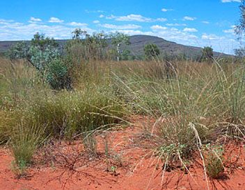
Central Mount Stuart
For a time he tried to lecture on his exploits and achievements in Australia but his poor health, and failing eyesight and memory, proved an embarassment. He retired to the home of his sister in London and died in June, 1866. He is buried in Kensal Green cemetery.
CENTRAL MOUNT STUART
On April 23, 1860 Stuart located the geographical centre of Australia, near a mountain he named Central Mount Stuart after Charles Sturt, who he had joined on his failed expedition of 1844 to find the centre. Later it became known as Central Mount Stuart.
Charles Ross, the surveyor for the Overland Telegraph line followed much of Stuart's route and on January 3, 1871 sighted the mountain and the following day, began the climb to look for the bottle that had been left there by Stuart.
They found the cone of stones that Stuart had built and what was left of the flagpole. The bottle contained a note describing the raising of the flag to commemorate the event and a description of the location of the exact centre of Australia;
Just looking at the Stuart Highway today it's very difficult to imagine the difficulties with which our early explorers had to work. For example, it takes us a day to travel what John McDouall Stuart took three months to do.
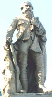
Stuart statue, Adelaide
COMMEMORATION Even though it’s almost a century and-a-half since John McDouall Stuart and his party completed their epic crossing of the continent from Adelaide through the centre to the northern coastline, the memory of that momentous journey is very much alive, particularly in South Australia. An active group of descendants of members of Stuart’s party, and others appreciative of his feat, have perpetuated it over the years in a variety of ways. Of course, memorials have been erected in the past but, in more recent times, a society of Stuart enthusiasts has ensured his name is unlikely to ever be forgotten.
Members gather annually at his statue in Victoria Square, Adelaide, to honour him and those who travelled with him, and to celebrate their achievements. This was one of Australia’s most valuable explorations, paving the way for the vital overland telegraph linking Australia’s isolated colonies to the international network, proving the agricultural worth of the inland and opening up the Northern Territory for European settlement. Society members listen to discussion about Stuart and his men, commemorate significant occasions and receive a regular newsletter that publishes material about the great trek and its continuing connections that remains pertinent and informative.
This year, as for the past 40 years, Stuart and his colleagues were remembered with respect and feeling in Victoria Square, where the explorer, looking resolutely towards the direction he took in 1861, stands with rifle, sextant, quadrant, journal and the Union Jack. And, as in the past, the occasion was marked by a fully-fledged ceremony and wreath-laying, attended by the Lord Mayor, Mr Michael Harbison, followed by the society’s annual meeting at which vice-president Rick Moore delivered the memorial address that focused on the subsequent pastoral and mining benefits that resulted from Stuart’s journeys.
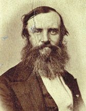
John McDouall Stuart - rare photograph
LINKS and REFERENCE
A taste for adventure
A heartwarming adventure: pirate whalers V conservationists across the coral sea to Fraser Island
|
|||
|
his
website
is Copyright © 1999 & 2012 NJK. The bird |
|||
|
AUTOMOTIVE | BLUEPLANET | ELECTRIC CARS | ELECTRIC CYCLES | SOLAR CARS | SOLARNAVIGATOR |