|
John o' Groats (Taigh Iain Ghròt in Scottish Gaelic) is a village in the Highland council area of
Scotland. It is often called "The start of Great Britain" as John o' Groats is on the northeastern tip of Scotland. Part of the historical county of Caithness, John o' Groats is popular with tourists because it is one end of the longest distance between two inhabited points on the island of Great Britain, being on the north east end, with Land's End being the other end, 876 miles to the south west. It is not quite the most northerly point on the island of Great Britain because nearby Dunnet Head is further north.
John o' Groats is 690 miles (1,110 km) from London, 280 miles (450 km) from Edinburgh, 6 miles (9.7 km) from the Orkney Isles and 2,200 miles (3,500 km) from the North Pole. It is 4.25 miles (6.84 km) from the uninhabited island of
Stroma. A passenger ferry operates from John o' Groats to Burwick on South Ronaldsay in Orkney.
The town takes its name from Jan de Groote, a Dutchman who obtained a grant for the ferry from the Scottish mainland to Orkney, recently acquired from Norway, from James IV, King of Scots, in 1496. The lower case and apostrophe in "John o' Groats" are regarded by many as correct, as the "o'" means "of" and thus is not cognate with Irish names that begin with O', even though that usage also denoted "of"; but the name can be found with the capital and/or without the apostrophe. People from John o' Groats are known as "Groatsers". Local legend has the name John o' Groats termed to reflect the
Dutch ferryman's charge of one groat payment for the journey to the islands.
The name John o' Groats has a particular resonance because it is often used as a starting or ending point for
cycles, walks and charitable events to and from
Land's End (at the extreme south-western tip of the Cornish peninsula in England). The phrase Land's End to John o' Groats (LEJOG) is frequently heard both as a literal journey (being the longest possible in Great Britain) and as a metaphor for great or all-encompassing distance, similar to the American phrase coast to coast.
Demography
The population of John o' Groats is approximately 300 ± 10. The village is dispersed but has a linear centre with council housing, sports park and a shop which is on the main road from the nearest town of Wick.
TOURISM
John o' Groats attracts large numbers of tourists from all across the world all year round. Not all commentary is good — in 2005 a popular tourist guide, Lonely
Planet, described the village as a "seedy tourist trap" and in 2010 John o' Groats received a Carbuncle Award from Urban Realm magazine for being "Scotland's most dismal town". 2013 however saw the completion of major redevelopment work which hopes to revitalise the area.
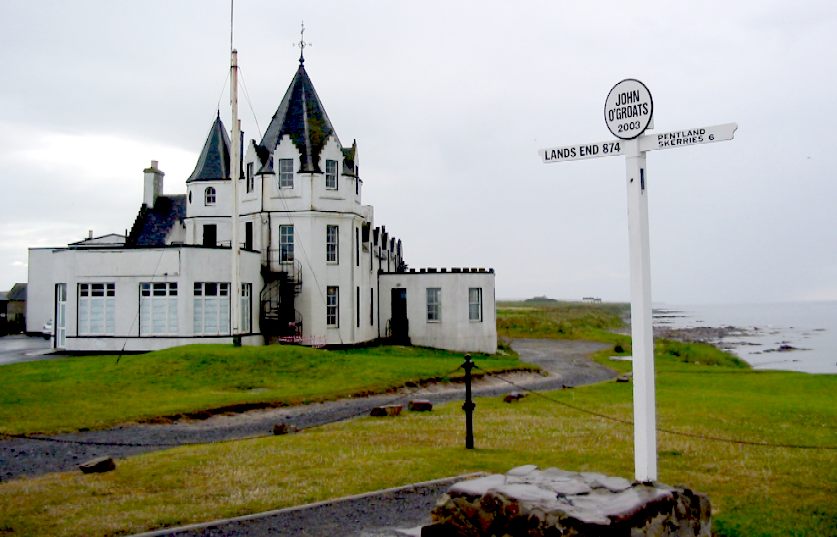
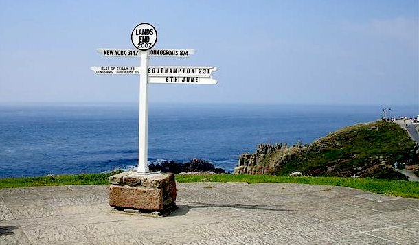
SIGNPOST
The famous "Journey's End" signpost at John o' Groats was until 2013 privately owned and operated by the same Penzance-based photography company that operates its counterpart at
Land's End, with a fee payable for having pictures taken next to the signpost. With the re-opening of the Hotel, a new permanent (and free) sign was erected.
Sport
John o' Groats is home to two football clubs: John o' Groats and John O Groats Juniors. John o' Groats FC is an amateur team which plays in the top flight of Caithness Amateur
Football; it also enters a team into the Winter 7s which are played in Thurso. They also have the distinction of being the most northerly clubs on the island of Great Britain. Canisbay Juniors is the "feeder" team to John o' Groats FC, with many of the key first team players having played for the juniors side at one time; they play in the youth development leagues in Caithness where the club enters teams in all age groups. The John O Groats Juniors Under 15s of 2012 were regarded as the best in the county and best ever junior Groats side.
HOTEL
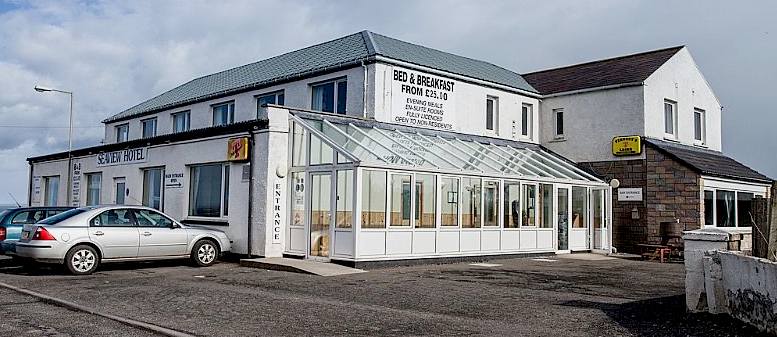
The John o' Groats House Hotel was built on or near the site of Jan de Groot's house and was established in 1875. It has been described by Highlands and Islands Labour MSP Rhoda Grant as "one of the UK's most famous landmarks". It was closed for several years and fell into disrepair until undergoing a radical transformation by Edinburgh based architects GLM for self-catering holiday specialists Natural Retreats. It reopened for business in August 2013.
John o' Groat's House was an ancient house believed to be situated in front of the present hotel and was mark with a flagpole now removed, deriving its name from John of Groat, or Groot, and his brothers, originally from Holland, said to have settled here about 1489. The house was of an octagon shape, being one room, with eight windows and eight doors, to admit eight members of the family; the heads of different branches of it, to prevent their quarrels for precedence at table. Each came in by this contrivance at his own door, and sat at an octagon table, at which, of course, there was no chief place or head.
— Haydn's Dictionary of Dates
CAITHNESS
Caithness (Scottish Gaelic: Gallaibh [ˈɡ̊al̪ˠɪv], Scots: Caitnes) is a registration county, lieutenancy area and historic local government area of Scotland.
Caithness has a land boundary with the historic local government area of Sutherland and is otherwise bounded by sea. The land boundary follows a watershed and is crossed by two roads, the A9 and the A836, and one railway, the Far North Line. Across the Pentland Firth
ferries link Caithness with Orkney, and Caithness also has an airport at Wick. The Pentland Firth island of Stroma is within Caithness.
The name was used also for the earldom of Caithness and the Caithness constituency of the Parliament of the United Kingdom (1708 to 1918). Boundaries are not identical in all contexts, but the Caithness area is now entirely within the Highland council area.
Caithness is one of the Watsonian vice-counties, subdivisions of Britain and Ireland which are used largely for the purposes of biological recording and other scientific data-gathering. The vice-counties were introduced by Hewett Cottrell Watson who first used them in the third volume of his Cybele Britannica published in 1852. He refined the system somewhat in later volumes, but the vice-counties remain unchanged by subsequent local government reorganisations, allowing historical and modern data to be more accurately compared. They provide a stable basis for recording using similarly-sized units, and, although grid-based reporting has grown in popularity, they remain a standard in the vast majority of ecological surveys, allowing data collected over long periods of time to be compared easily.
SCOTTISH HIGHLANDS
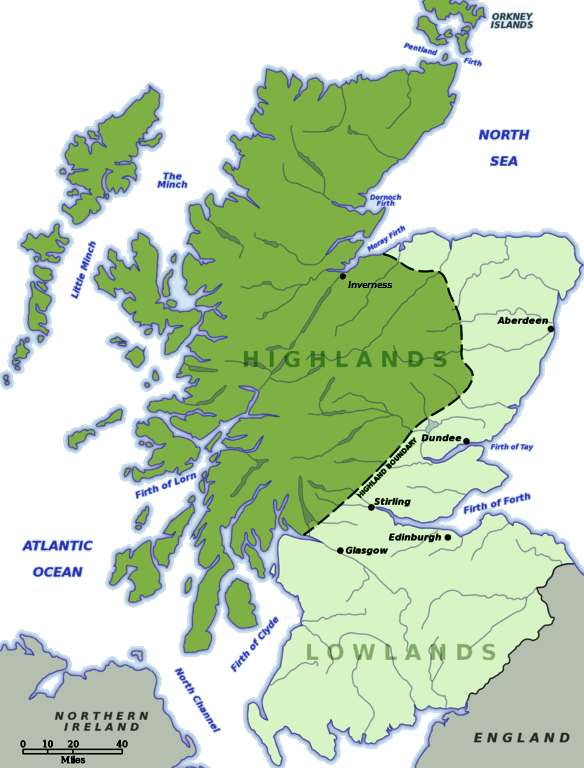
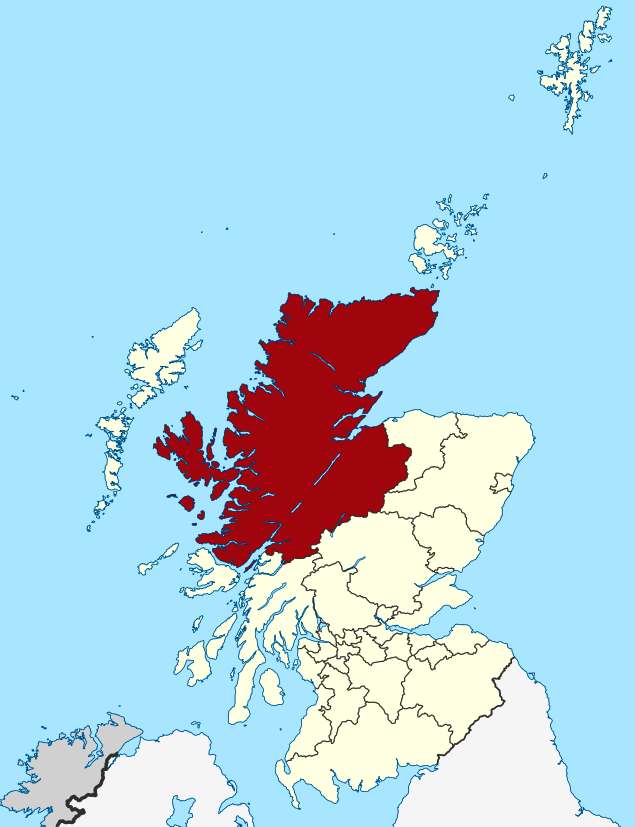
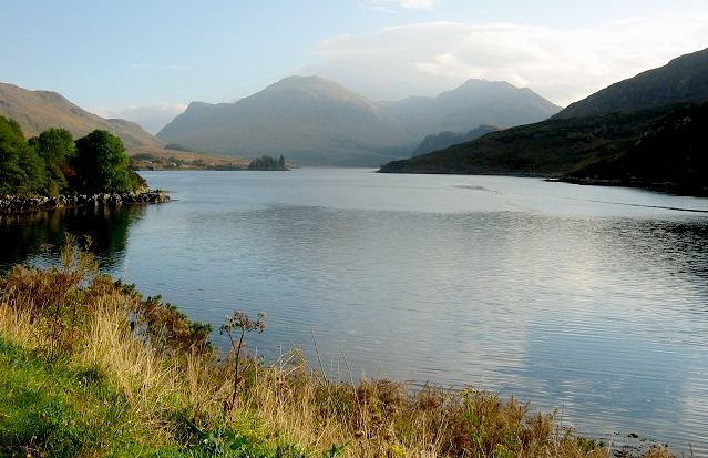
The Scottish Highlands, known locally simply as the Highlands (Scottish Gaelic: A' Ghàidhealtachd, "the place of the Gaels"; Scots: the Hielands) are a historic region of Scotland. The region became culturally distinguishable from the Lowlands from the later Middle Ages into the modern period, when Lowland Scots replaced Scottish Gaelic throughout most of the Lowlands. The term is also used for the area north and west of the Highland Boundary Fault, although the exact boundaries are not clearly defined, particularly to the east. The Great Glen divides the Grampian Mountains to the southeast from the Northwest Highlands. The Scottish Gaelic name of A' Ghàidhealtachd literally means "the place of the Gaels" and traditionally, from a Gaelic-speaking point of view, includes both the Western Isles and the Highlands.
The area is very sparsely populated, with many mountain ranges dominating the region, and includes the highest mountain in the British Isles, Ben Nevis. Before the 19th century the Highlands was home to a much larger population, but due to a combination of factors including the outlawing of the traditional Highland way of life following the Jacobite Rising of 1745, the infamous Highland Clearances, and mass migration to urban areas during the Industrial Revolution, the area is now one of the most sparsely populated in Europe. At 9.1 per km2 in 2012, the population density in the Highlands and Islands is less than 1/7th of Scotland's as a whole, comparable with that of Bolivia, Chad and
Russia.
The Highland Council is the administrative body for much of the Highlands, with its administrative centre at Inverness. However, the Highlands also includes parts of the council areas of Aberdeenshire, Angus, Argyll and Bute, Moray, Perth and Kinross, and Stirling. Although the Isle of Arran administratively belongs to North Ayrshire, its northern part is generally regarded as part of the Highlands.
The latest Census figures released by the National Register of Scotland, show that the Highland’s population has risen by 23,000 between 2001 and 2011 to 232,000.
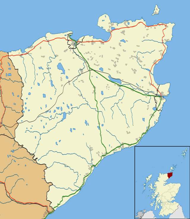
Location
maps of Caithness and the Scottish Highlands
HIGHLAND COUNCIL AREA
The Highland Council area, created as one of the local government regions of Scotland, has been a unitary council area since 1996. The council area excludes a large area of the southern and eastern Highlands, and the Western Isles, but includes Caithness. Highlands is sometimes used, however, as a name for the council area, as in Highlands and Islands Fire and Rescue Service. Northern, as in Northern Constabulary, is also used to refer to the area covered by the fire and rescue service. This area consists of the Highland council area and the island council areas of Orkney, Shetland and the Western Isles.
Highland Council signs in the Pass of Drumochter, between Glen Garry and Dalwhinnie, say "Welcome to the Highlands".
HIGHLANDS and ISLANDS
Much of the Highlands area overlaps the Highlands and Islands area. An electoral region called Highlands and Islands is used in elections to the Scottish Parliament: this area includes Orkney and Shetland, as well as the Highland Council local government area, the Western Isles and most of the Argyll and Bute and Moray local government areas. Highlands and Islands has, however, different meanings in different contexts. It means Highland (the local government area), Orkney, Shetland, and the Western Isles in Highlands and Islands
Fire and Rescue Service. Northern, as in Northern Constabulary, refers to the same area as that covered by the fire and rescue service.
LANDS END TO JOHN O'GROATS - LEJOG
Land's End to John o' Groats is the traversal of the whole length of the island of Great Britain between two extremities; in the southwest and northeast. The traditional distance by road is 874 miles (1,407 km) and takes most cyclists ten to fourteen days; the record for running the route is nine days. Off-road walkers typically walk about 1,200 miles (1,900 km) and take two or three months for the expedition. Two much-photographed signposts indicate the traditional distance at each end.
Land's End is the extreme southwestward (but not southern or western) point of Great Britain, situated in western Cornwall at the end of the Penwith peninsula, O.S. Grid Reference SW342250, Post Code TR19 7AA. The most southerly point is Lizard Point.
John o' Groats is the traditionally acknowledged extreme northern point of mainland Scotland, in northeastern Caithness, O.S. Grid Reference ND380735, Post Code KW1 4YR. The actual northernmost point is at nearby Dunnet Head. The point that is actually farthest by road from Land's End is Duncansby Head, about 2 miles (3.2 km) from John o' Groats.
The straight-line distance from Land's End to John o' Groats is 603 miles (970 km) as determined from O.S. Grid References, but such a route passes over a series of stretches of water in the Irish Sea.
According to a road atlas of 1964, the shortest route using classified roads was 847 miles (1,363 km). According to a road atlas of 2008, the shortest route using classified roads was 838 miles (1,349 km). In 2011 an online route planner calculated the quickest route by road as 838 miles (1,349 km), estimating a time of 15 hours 48 minutes for the journey (this uses A30, M5, M6, A74(M), M74, M73, M80, M9, A9 & A99). However, the overall shortest route by road, using minor roads in numerous places and utilising modern bridges, has been reduced to around 814 miles (1,310 km). This route is roughly follows: Land's End, Bodmin, Okehampton, Tiverton, Taunton, Bridgwater, the M5 Avon Bridge, the M48 Severn Bridge, Monmouth, Hereford, Shrewsbury, Tarporley, St Helens, Preston, Carlisle, Beattock, Carstairs, Whitburn, Falkirk, Stirling, Crieff, Kenmore, Dalchalloch, A9, Inverness, Kessock Bridge, Cromarty Bridge, Dornoch Firth Bridge, Latheron, Wick, John o' Groats.
MOTORING HISTORY
Motoring events between the two extremities have been held since the first decade of the 20th century, when the Auto-Cycle Union organised a series of runs for motorcycles. In 1911, Ivan B. Hart-Davies became the holder of the final Land's End to John o' Groats record for solo motorcycles. Riding his 3.5 hp single-speed Triumph, he covered the 886 miles in 29 hours, 12 minutes. As his average speed exceeded the then-maximum of 20 mph, further official record attempts were banned by the A. C. U.
The Motor Cycling Club (which had been running the London to Land's End Trial since 1908, still held today, at least in name) put on an annual Land's End to John o' Groats Run from 1923 to 1928 which included cars as well as motorcycles. These events were also known as the End to End. In 2006, BBC Television ran a series of three programmes called The Lost World of Friese-Greene covering Claude Friese-Greene's 1920s-era road trip from Land's End to John o' Groats. The trip had originally been filmed using the Biocolour process, developed by Claude's father William Friese-Greene and the film had degraded. The original print of Claude's film was subjected to computer enhancement by the British Film Institute to remove the flickering problem inherent in the Biocolour process.
In 1984, Neal Champion covered 884 miles from John o' Groats to Land's End in 11 hours, 14 minutes, on a Kawasaki GPZ750 Turbo.
On 17 September 1988, Andrew Frankel and Mark Connaughton drove from Land's End to John o'Groats in a standard production Alfa Romeo 164 in 12 hours 30 minutes, including stops for refuelling.
In 1993, John Brown initiated the Land's End to John o' Groats Historic Reliability Trial, a race for vintage road vehicles. The race is held each December and is a tough, three-day rally for old and classic cars, built between the 1920s and 1970s. The route takes a long 1,400-mile (2,300 km) route, using remote upland roads of the west of England, Wales (during the night), the Pennines and Scotland.
Medals are awarded in
gold, silver and bronze categories.
On 15–16 April 1997, Hugh Edeleanu drove the route in a JCB excavator in a time of 22 hours, 10 minutes and 30 seconds.
In June 2001, Wayne Booth became the first person to do the journey by motorcycle without stopping; the 37-year-old completed the historic trip in 14 hours and 52 minutes, averaging 57 mph, on a modified 1,000cc Honda Varedero, complete with additional 74 litre
petrol tank. The meticulously researched route of 854 miles passed through just two sets of traffic lights and was completed within all highway regulations, law and speed limits. Booth and the dozen strong support team raised over £1,000 for The National Childbirth Trust and MacMillan
Cancer Relief.
On 22 May 2011, Kevin Sharpe and David Peilow completed the first end-to-end run from John o' Groats to Land's End in an electric car over two days, using only charging points available to the general public, in a
Tesla Roadster Sport.
On 7 August 2011, Darren Whitehead & Tony Dwight travelled 1071 miles from John o' Groats to Lands' End (including crossing the Welsh border) in 5 days using two ride-on Wheel
Horse Lawn Mowers. They also raised money for
charity during the trip which was named The Lawn Way Down.
On 30th November 2013, Lucy Grogan (traveling on a BMW GS R1200 motorbike) and her father Martin Grogan (travelling in a
Mini Cooper Works)
traveled from Land's End to John o' Groat's in 19 hours, leaving Land's End at 4:30am and arriving at John o' Groat's at 11:30pm same day. This was in aid of Safe Haven Children's Trust and raised £3,000 for the non-governmental
organisation.
CANNONBALL
JOGLE
An
attempt by Team Speedace to beat
the EV record set by Tesla
in 2011, is planned for June of 2015, or as soon as possible after that
date in an electric sports car prototype called the Ecostar
DC50. The Cannonball
International series of zero emission vehicle runs is designed to
draw attention to global warming and the need for sustainable transport
policies.
TOURISM
Situated in an extreme location, the village boasts fantastic unspoilt scenery and offers wonderful landscapes and wildlife that is very special to this area, including a breathtaking array of birdlife on the local cliffs as well as
seals, dolphins, minke and
killer whales.
There is a lovely coastal walk from John O’ Groats along the north coast, from the east of the town to Duncansby Head Lighthouse and onto the massive rock stacks called the Stacks of Duncansby. Visitors can also take boat trips from the town to and around the wild cliffs of Duncansby Head that are up to 200 ft high and are home to many nestling
birds.
LINKS
and REFERENCE
Visit
Scotland john-o-groats
Natural
Retreats john-o'groats
Visit john ogroats
Jog Ferry
John o'Groats journal
Seaview Hotel John o'Groats Ride
Across Britain Wikipedia
Lands_End_to_John_o_Groats Wikipedia
Scottish_Highlands Wikipedia
Highland_council_area Wikipedia
Caithness Wikipedia
John_o_Groats Trip
Advisor
Natural_Retreats_John_O_Groats-John_O_Groats_Caithness_and_Sutherland_Scottish_Highland Wikipedia
Cornwall Visit
Cornwall Wikipedia
Penzance Wikipedia
Lands_End http://www.visitscotland.com/info/towns-villages/john-o-groats-p236231
http://www.naturalretreats.com/uk/john-ogroats/?gclid=CNLe-Jyf0cECFcfMtAodb3kADQ
http://www.visitjohnogroats.com/
http://www.jogferry.co.uk/Home.aspx
http://www.johnogroat-journal.co.uk/Home/
http://www.seaviewjohnogroats.co.uk/
http://www.rideacrossbritain.com/ http://en.wikipedia.org/wiki/Land%27s_End_to_John_o%27_Groats http://en.wikipedia.org/wiki/Scottish_Highlands http://en.wikipedia.org/wiki/Highland_%28council_area%29 http://en.wikipedia.org/wiki/Caithness http://en.wikipedia.org/wiki/John_o%27_Groats http://en.wikipedia.org/wiki/Cornwall http://www.visitcornwall.com/ http://en.wikipedia.org/wiki/Penzance http://en.wikipedia.org/wiki/Land%27s_End
|
Adelaide
Aden
- Yemen
Afghanistan
Africa
Alaska
Algeria
Amsterdam
Antarctic
- Antarctica
Arctic
- North
Pole
Argentina
Asia
Athens
Australia
Austria
Aztecs
- Mexico
Bahamas
Bangladesh
Baghdad
Bahrain
Barbados
Beachy
Head, England
Belgium
Berlin
Bermuda
Black
Rock Desert, Nevada
Bohemia
Bolivia
Bonneville,
Utah - History
Brazil
Brighton
- West Pier
British
Columbia
Bulgaria
Burma
Canada
Canary
Islands
Cape
Hope
Cape
York - Au
Caribbean
- Central America
Cayman
Islands
Chichester
Harbour
Chile
China
- Beijing
Columbia
- S. America
Columbo
- Sri Lanka
Cowes,
Isle of Wight
Croatia
Cuba
Cyprus
Czechoslovakia
Darwin
- Australia
Daytona
Beach
- Florida USA
Denmark
Dubai
Eastbounre
Pier, England
Earthquakes
Egypt
Equador
Equator
Europe
Falkland
Islands
Falmouth,
Cornwall
Fiji
Finland
Florida
France
Galapagos
Islands
Geography
Links
Geography
Records
Geography
Resources
|
Geography
Statistics
Germany
Gibraltar
- Links
Greece
Greenland
Hampshire
Hawaii
Holland
- Volendam
Hollywood,
California, LA
Hong
Kong
Hungary
Hurricanes
Iceland
India
- Mumbai
Indonesia
Links
Iran
Iraq
Ireland
Isle
of Man
Isle
of Wight
- The
Needles
Israel
Italy
Jakarta
- Java
Jamaica
Japan
Jordan
Kent,
England - Sandgate
Kenya
Korea
Kuwait
Kyoto
- Japan
Las
Vegas -
Lebanon
Libya
Life
on Earth
London
- Big
Ben
London
Eye - Madame
Tussauds
London
Houses
Parliament
London
- Buckingham
Palace
London
- Old
Bailey
London
- Overview
London
- The City
London
- Tower Bridge
London
- Trafalgar
Square
Luxembourg
Malaysia
Malta
Maya
Empire -
Central America
Melbourne,
Australia
Mexico
Middle
East
Monaco
Morocco
Mountains
Naples-
Italy
National
Geographic
Nepal
Nertherlands
- Eindhoven
New
York
New
Zealand
Nigeria
North
Africa
Norway
Nova
Scotia
Oceans
and Seas
Oman
Pakistan
Palermo
- Sicily
Palestine
|
Palma
- Malorca
Panama
Canal - Links
Paris
Pendine
Sands - Carmarthen
Peru
Philippines
Pisa
Planet
Earth
Poland
Port
Moresby - PNG
Port
Said - Egypt
Portugal
Puerto
Rico
Qatar
Quebec
Rio
de Janeiro
Romania
Rome
Russia
Salt
Lake City - Utah
Saudi
Arabia
Scotland
Senegal
West Africa
Singapore
Somalia
South
Africa
South
America
Southampton
Spain
- Espana
Sri
Lanka - Links
Stonehenge
Suez
Canal
Sudan
Surrey,
England Index
Sussex,
England Index
Sweden
Switzerland
Sydney,
Australia
Syria
Tahiti
- Polynesia
- Links
Taiwan
Thailand
Tokyo,
Japan
Tonga
- Polynesia
Toronto
Trinidad
- Lesser Antilles
Tsunami
Tunbridge
Wells, England
Tunisia
Turkey
UAE
- United Arab Emirates
UK
Statistics
Ukraine
United
Kingdom
United
Kingdom -
Gov
USA
Venezuela
Venice
Vienna
Vietnam
Volcanoes
Wales
Washington
D.C.
Wealden
iron industry
Wendover,
Utah
World
Peace Supporters
Yemen
Yugoslavia
Zurich
|
Solar
Cola drinkers care about climate chaos
...
..
Thirst for Life

330ml
Planet Earth can and 500ml bottle
|