|
PEVENSEY CASTLE
Please use our A to Z INDEX to navigate this site
|
|||||||||||||||||||
|
Sussex is a glorious county, the so-called garden of England and for very good reason. I've lived in Sussex most of my life, including: Brighton, Eastbourne, Seaford, Newhaven, Hadlow Down, and of course Herstmonceux.
There is so much of interest to see and do in the United Kingdom, and we hope to expand the local geography section as time allows, to cover the most interesting aspects of this wonderful country.
Pevensey Castle is a castle at Pevensey, near Eastbourne in Sussex, England. The ruins of the medieval castle at Pevensey stand in one corner of a Roman fort, on what was once a peninsula surrounded by the sea and salt marshes. The Roman fort, named Anderida, was built in about AD 290. It is one of the largest surviving examples in Britain, with two thirds of its walls and towers still standing to almost their original height. Unlike most Roman forts that were built to a standard rectangular plan, Anderida has an irregular oval layout that follows the shape of the peninsular.
Pevensey Castle aerial view
Roman fort
It was first built as Anderida or Caer Andred, a Saxon Shore Fort between 300 and 340 by the Romans during a time when Britain was still part of the Roman Empire. At this time the south and east of the province Britannia were under constant attack from marauding barbarian tribes, namely the Jutes and Saxons. The south and eastern seaboards of Britannia were collectively known as "the Saxon Shore" and several large forts were built to defend it.
The fort was built on what was then an uninhabited peninsula of land rising above the coastal marshes. The sea washed over what is now Pevensey Marshes surrounding Anderida on three sides, so giving a safe and sheltered landing point. This marshy inlet of the sea, extending inland as far as Hailsham, was studded with small areas of high land which remained as islands at high tide so giving the place-names of Rickney, Horse Eye, North Eye and Pevensey. All are derived from the Old English word 'eye' meaning island.
The fort was repaired, probably by the great Roman General Stilicho, about AD 400. The massive Roman enceinte still stands but little damaged.
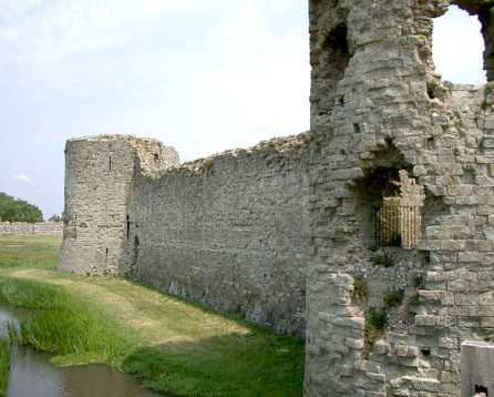
Pevensey Castle moat facing east
Architectural Features
The Castle enjoys dungeons and passages, spiral staircases and basement rooms Three main curtain towers remain and the North, East and South of the Castle.
It is moated with a drawbridge, Roman outer walls and remains of the once grand medieval castle keep. Two thirds of the Roman fort walls remain standing at full height and the ruins of a twin-towered medieval gatehouse are still standing.
There is also a postern gate which gave direct access to the medieval shore, and a fifty foot well lined with stone. Once within the castle walls one can view the stone foundations of the Chapel which once stood within the Castle.
“The Rape of Pevensey is of a curious shape. [Sussex is divided into six regions called Rapes] It narrows somewhat towards the middle and bulges out towards the top, or north end. This appears to be the contrary of what one would expect in a Sussex division, the important part of which always lay round the sea cost [to the south], but the cause of the shape thus assumed by the Rape is that in its northern part the iron industry had arisen long before the Norman Conquest [1066], and had thus opened up the Weald; it had also made the government of the area and the collection of taxes from it a subject of ambition for the strongest of the neighbouring lords.
“The name Pevensey is instructive of its antiquity. It is probably derived from Celtic roots signifying “the fortification at the far end of the wood,” which would exactly describe an important and fortified sea-coast town situated as Pevensey was situated to the forest from which it took its Roman name; for “Anderida,” or “Andresio,” certainly refers to the Weald, the Celtic forest of “Andred,” of which the Saxons made the “Andredswald.”
"It is doubtful whether anything of Roman structure remains in Pevensey, though much of the material used in that castle is Roman, and though the towers of that fortification are round. It is enough to remark, that after the long night of the Saxon period the town shared in the general renaissance of South England which followed the Norman Conquest. To give but one indication of this: it trebled in population in twenty years. There is little doubt that at this period, that is, throughout the end of the eleventh century, the whole of the twelfth, and beginning of the thirteenth, the harbour lay beneath the mound of the present ruins. The contour lines, slight as they are in elevation, and the nature of the soil are enough to prove this; nor is it difficult, as one stands on the height of Pevensey Castle to reproduce the scene which must have presented itself to the eye of a man living six hundred years ago when he looked northwards and eastwards at high tide.”
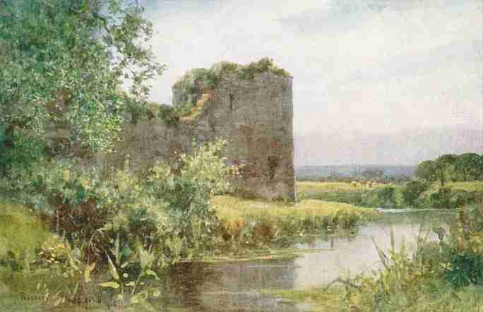
Pevensey Castle painting Wilfred Ball 1906
Roman fort
It was first built as Anderida or Caer Andred, a Saxon Shore Fort built by the Romans during a time when Britain was still part of the Roman Empire. Recent dendochronological dating of wooden foundation piles have dated this to AD 290. At this time the south and east of the province Britannia were under constant attack from marauding barbarian tribes, namely the Jutes and Saxons. The south and eastern seaboards of Britannia were collectively known as "the Saxon Shore" and several large forts were built to defend it.
The fort was built on what was then an uninhabited peninsula of land rising above the coastal marshes. The sea washed over what is now Pevensey Marshes surrounding Anderida on three sides, so giving a safe and sheltered landing point. This marshy inlet of the sea, extending inland as far as Hailsham, was studded with small areas of high land which remained as islands at high tide so giving the place-names of Rickney, Horse Eye, North Eye and Pevensey. All are derived from the Old English word 'eye' meaning island.
The fort was repaired, probably by the great Roman General Stilicho, about AD 400. The massive Roman enceinte still stands but little damaged.
Saxons
The fall of Anderida in 491 to invading Saxons under the command of King Aelle and the subsequent slaughter of its garrison and burning of the fort to the ground was a turning point in the Romano-British defence of the south-east coast. Following its demise the British inhabitants of the south-east fled northwards to the comparative safety of the impassable forests of the Coit Andred (also known as The Weald) or by boat for Armorica in northern Gaul. In their place King Aelle established the Kingdom of the South Saxons from which we get the modern name Sussex.
The site lay abandoned for 600 years after 491 and was for a while known by the Saxons as Andredceaster, with the Weald of southern England from Anderida to Dorset named Andredsweald or the Forest of Andred.
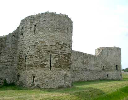
View from the inner bailey showing the outer Roman curtain wall
Late Saxons and Normans
The site was next occupied in 1042, when an Anglo-Saxon noble (Harold Godwinson, Earl of Wessex - later King Harold II of England) established a strong point here, improving fortifications by digging ditches within the walls of the Roman Fort. The English army remained at the fort during the summer of 1066 before abandoning it to meet the invading Norwegians further north. When the Duke William the Bastard of Normandy invaded Sussex, landing at Pevensey Bay in September 1066, there were no defences at Pevensey or anywhere else on the south coast. Upon landing, the invading Normans created a temporary fortification within the Roman walls.
In September 1066 at the ensuing Battle of Hastings on Senlac Hill, Duke William of Normandy defeated the combined English armies led by King Harold II, having landed his invading army and setting up a defensive camp before marching to Hastings. Following his victory, William gave Pevensey to his half-brother, Robert, Count of Mortain.
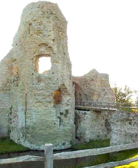
Remnants of Castle drawbridge
In late 1066 the castle at Pevensey was occupied by the Normans. Much of the Roman fort remaining on the castle site is due largely to the work of Robert of Mortain (half brother to William the Conqueror), who was granted Pevensey Castle shortly after the Norman Conquest. De Mortain used the existing fort as the base for building his castle, carrying out only minor repairs to the walls forming the outer bailey, and building a new inner bailey at the eastern end.
A new gateway replaced the original main entrance to the southwest, and the east gateway was repaired. Other alterations made were mainly additions and improvements to existing structures within the original fort. An irregular, rectangular-shaped enclosure was created using part of the Roman wall and two bastions on the southeastern side. Shortly after the inner bailey was created, the rectangular stone keep was erected, incorporating part of the east curtain wall and a Roman bastion. Some time later, three more bastions facing the inner bailey were added to the keep.
The castle was besieged by William Rufus in the Rebellion of 1088 and during a period of civil war by the forces loyal to King Stephen (1135-1141).
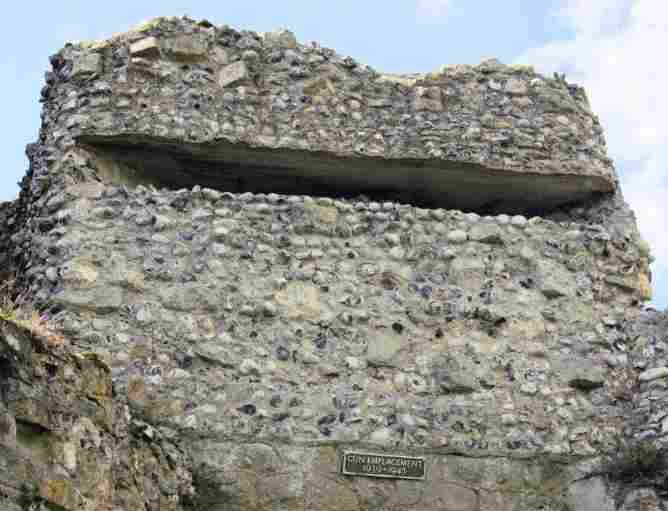
The castle developed gradually over the centuries with phases of building interspersed by periods of decline, including the slighting of the castle by King John in 1216. The castle was rebuilt and remained occupied into the 15th century, by which time it served as a state prison. The castle's strategic location as a possible landing point for foreign invaders gave it an importance that led to several sieges over the course of its history, and even after it had fallen into ruin it was put to use for the defence of the country. A gun emplacement was built at the time of the Spanish Armada, and during the Second World War machine-gun posts and billets for troops were created within the remains of the castle. The pillboxes can still be seen at the castle, camouflaged to look like the rest of the building.
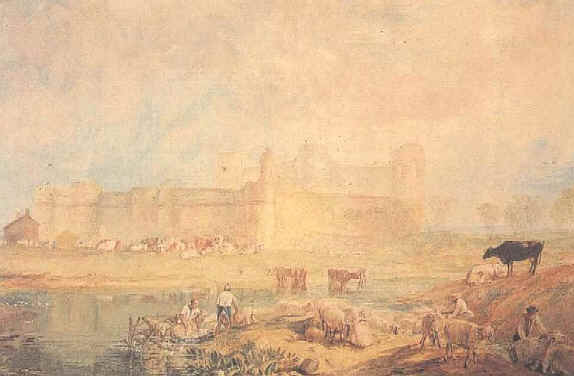
Pevensey Castle by JMW Turner 1817
Post Norman
Simon de Montfort, on his way back from taking Lewes, besieged the castle in 1264.
1500 to present
During later times the ancient castle nearly did not survive. Queen Elizabeth I ordered the castle to be demolished but this was ignored and during the period of interegnum under Oliver Cromwell efforts were again made to destroy it but luckily only a few stones were removed. As late as 1942 small additions were made to the castle for the defence of Britain when it became a look-out over the channel for invading German warplanes and a pillbox during World War II.
Entrance to the Roman fort is free, but there is a charge to enter the medieval castle.
Address: Castle Road, Pevensey, East Sussex, BN24 5LE
OS Grid Ref: TQ644051
Telephone: 01323 762604
World War II modifications to Pevensey castle - gun emplacement
Pevensey Castle had once been a Roman fort and William the Conqueror landed near the castle in 1066. Before marching to Hastings William repaired the castle and used it to regroup his invasion force. After the Conquest William granted the castle to his half-brother Robert, Count of Mortain. Of the existing castle Robert found Roman walls 20 to 30 feet high and 10 feet in thickness. The castle was repaired and improved to such an extent that it proved to be hard to overcome. It stood up to sieges in 1088 by William Rufus and again in 1147 when King Stephen laid siege to it until the trapped soldiers, lead by Gilbert de Clare, ran out of food.
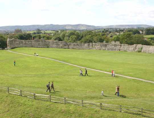
Pevensey Castle north walls and grounds
SUSSEX INDEX A - Z
ARUNDEL CASTLE - WETLANDS WILDFOWL TRUST BEACHY HEAD - BELL TOOT (BELLE TOUT) LIGHTHOUSE BISHOPSTONE CHIDDINGLY - HORSE SHOW and GYMKHANA CUCKMERE VALLEY - EXCEAT EAST
SUSSEX HADLOW DOWN HERSTMONCEUX - CASTLE - CE SCHOOL - LINKS - FESTIVAL - MUSEUM LIME PARK - HERSTMONCEUX - AUGUSTUS HARE SHOREHAM - PORT SUSSEX - SUSSEX BAY, MARINE REWILDING PROJECT TWISSELLS MILL, OLD HEATHFIELD WEALDEN DISTRICT COUNCIL - COUNCILLORS 2023
Solar Cola drinkers care about planet earth
.. Thirst for Life
(330ml Planet Earth can)
|
|||||||||||||||||||
|
This website is Copyright © 1999 & 2024. The bird logo and name Solar Navigator and Solar Cola are trademarks. All rights reserved. All other trademarks are hereby acknowledged. Max Energy Limited is an environmental educational charity.
|