|
ROBOT SHIP COLLISION AVOIDANCE SOFTWARE
|
||||||||||||||||||||||||||||||||||||||||||||||
|
A great deal of the hardware and software that is needed to complete our autonomous challenge, is available off the shelf. It could be argued that it may be possible to arrange for autonomous travel without developing dedicated hard and software, using model radio control techniques as follows:-
1. Autopilot steers correct heading at all times (even when ship not moving) waypoint to waypoint. 2. Motors engaged at all times subject to proximity sensors all clear (subject to 5 below). 3. Sensors give all clear - motor drive engaged subject to energy management. 4. Storm sensors disengage 2. above (stop motors) and engage degrees of lock down. 5. Collision avoidance software overrides 1. (ship performs avoidance moves as per COLREGS below) 6. Autopilot can be reprogrammed with a new mission via satellite link; i.e. monitored. 7. Manual steering (drone mode) override disengages 1. 8. International monitoring system, warning ships so equipped of developing situation.
Five above could be achieved with existing navigation and radio control equipment and software, but in that case the level of artificial intelligence (AI) would be low - in our opinion, insufficient to the task of advancing marine navigation - as compared to a system imbued with a high level of AI. The positioning of sensors about a ship, and the mix of sensors are the key to success, allied to the high level AI that we have set ourselves as the challenge.
There are long and short range sensors (radar, laser, infra red and optical recognition), each having their separate circuits for Class 3 type multiple redundancies. The present proposal is for a physical switching system (as per 1-8 above) for the eventual development of a cost effective solid state AI package, as and when funding might be achieved for SNAV.
Such a system will benefit from a program for the sensors and steering, to increase system reliability for general navigation use. The challenge is simple:-
COLREGS REAL WORLD INTERFACE - COLLISION AVOIDANCE PROGRAM
Complying with the existing rules of the road is a priority if autonomous ships are to gain favour with the authorities and advance the art of navigation. After that stage is achieved, we might then see how new technology (autonomy) might improve safety at sea. Thus the basis for our software development (@ 5 above) are these internationally accepted rules of navigation at sea:-
Rule 1 - Application (rules apply to all vessels) Rule 2 - Responsibility (no excuses for non compliance) Rule 3 - General definitions (vessel includes all water craft) Rule 4 - Application (in any condition of visibility) Rule 5 - Look-out (sight & hearing at all times) Rule 6 - Safe speed (conditions determining) Rule 7 - Risk of collision (radar & compass bearings + Snav improvements) Rule 8 - Action to avoid collision (positive duty in good time) Rule 9 - Narrow channels (keeping as far away as possible anchor avoidance) Rule 10 - Traffic separation schemes (no relief of any other rule) Rule
11 - Application (in sight of another vessel) Rule
14 - Head-on situation (power vessels alter course to starboard - pass on
port) Rule
19 - Conduct of vessels in restricted visibility (safe speed & avoidance) Rule 24 - Towing and pushing (masthead lights) Rule
25 - Sailing vessels underway and vessels under oars (mast, side, stern
lights) Rule
28 - Vessels constrained by their draught (lighting) Rule 32 - Definitions (whistle definitions) Rule 33 - Equipment for sound signals (bells and whistles) Rule 34 - Manoeuvring and warning signals (whistle blasts and light flashes for direction) Rule
35 - Sound signals in restricted visibility (fog, 2 sec blasts) Rule 37 - Distress signals (prescribed and Snav)
These rules can be subdivided into:-
A. Optical, B. Audible and C. Electronic - compliance requirements, D. Steerage action to avoid collision, E Speed reduction/acceleration/stop as reasonable as conditions dictate.
The requirements of 'A-C' are relatively easy to satisfy. That required to ensure 'D' is not so easy to arrange, to avoid collision.
COLLISION AVOIDANCE
We propose an overlap of sensors to provide information of the real world in real time as follows:-
* Sensors sensitive to 0-30 meters proximity. * Sensors sensitive to 0-1000 meters proximity. * Sensors sensitive to 0-3000 meters proximity. * Sensors capable of color differentiation. * Sensors capable of identifying sounds and sound direction. * Range sensitive heat sensors. * Subsurface equivalents of 1-3 and 5.
We propose sensor positioning as per the following diagrams:
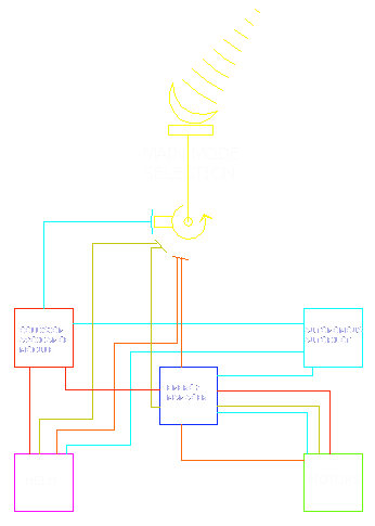
LOGICAL SWITCHING BLOCK DIAGRAM
STATE
OF THE ART - MARITIME TRAFFIC MANAGEMENT AROUND THE WORLD -
SNAV Bridge Console & STCC
The STCC will active control the
ensemble of all routes in an area and transmission of routes on high sea will be performed by
via secure satellite communication.
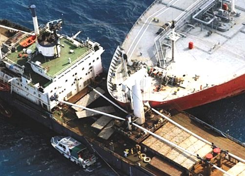
Imagine - the human crews of these two ships lapsed in concentration. An onboard monitoring system does not take naps or need to use the toilet. It does not telephone the missus or call the kids. It just keeps on working 24/7 to protect the investment of fleet operators and save lives..
When large cargo ships traverse narrow waterways, the careful management and navigation of their passage is critical to maximizing efficiency, safety and security. The Center for Navigation at the Volpe Center has developed several systems that improve navigation in shipping channels. In December 2000, the Center completed the installation of a state-of-the-art system in the Panama Canal. Subsequently, similar systems were installed in Central American ports to restore navigation capabilities that were destroyed by hurricanes. Building on these successes, the Center designed and implemented a comprehensive vessel communications and tracking network that will identify and track all commercial vessels on the Saint Lawrence Seaway.
The network, based on automatic identification system (AIS) technology, provides signal coverage from Montreal to eastern Lake Erie. The system enables automatic vessel position reporting from vessels equipped with AIS transponders to the Seaway Traffic Management System. In turn, the shoreside AIS network provides vessel traffic services information, such as wind speeds, water levels, visibility conditions, and lock schedules to transiting ships.
The project was developed by the Center for Navigation under the sponsorship of a consortium composed of the Saint Lawrence Seaway Development Corporation, the Canadian St. Lawrence Seaway Management Corporation, The Shipping Federation of
Canada, and the Canadian Shipowners Association. The
U.S. and Canadian Seaway agencies jointly operate the Seaway's locks and channels, and also provide traffic management for the waterway.
The vessel management system is one of the important up gradations that has taken place in the shipping sector. The vessel management system uses advanced technological equipments to monitor and manage the vehicular traffic in the oceanic and sea waters. Working on the basis of
GPS and other gadgets like a computer for the purpose of display, vessel management has become a very integral part of the
naval system without which there could be a lot of problems pertaining to management of the ships and other
naval vessels.
MEDWAY PORTS
UK -
Marine Vessel Traffic Services
NORCONTROL
-
Real-time fleet control
The purpose of a VTMIS is to provide the operator with a clear and concise real-time portrayal of vessel movements and interactions in the Vessel Traffic Service
(VTS) Area. The information provided by the VTMIS must allow the operator to:
VTMIS5060 fulfils this purpose by processing and presenting information in a manner which enables the operator to obtain a clear and accurate picture of the vessel traffic situation, quickly understand and assess situations, make appropriate decisions and take appropriate action where necessary.
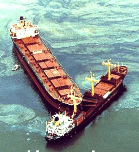
Imagine - these ships had no robot captain to warn the humans onboard as to the consequences of their failure to react to a developing situation. "Of all the oceans in all the world you just happened to be cruising in mine." Quote: Captain Humphrey Bogart
LINKS www.gps4us.com/GPS-independent-navigation-system-for-autonomous-vessels Innovateuk competition vessel efficiency piloting uk marine maritime http://www.guidance.eu.com/ui/content/content.aspx?id=229 http://www.babcockinternational.com/ http://www.cs.cmu.edu/afs/cs/user/copetas/www/public/mobot/intro1.shtml
The Merchant Shipping (Distress Signals and Prevention of Collisions) Regulations 1996 Section 4. The application of these Rules is limited through the Regulations, to the vessels or ships as defined in the Merchant Shipping Act 1995. Application to craft falling outside of this definition e.g. WIGs, personal water craft and others; will therefore be subject to a Maritime and Coastguard Agency (MCA) opinion of what it considers to be good conduct and practice by the MSN 1781 (M+ F).
|
||||||||||||||||||||||||||||||||||||||||||||||
|
This website is copyright © 1991- 2014 Electrick Publications. All rights reserved. The bird logo and name Solar Navigator is a trademark ™. . All other trademarks hereby acknowledged and please note that this project should not be confused with the Australian: 'World Solar Challenge'™which is a superb road vehicle endurance race from Darwin to Adelaide. Max Energy Limited is an educational charity working hard to promote world peace.
|
||||||||||||||||||||||||||||||||||||||||||||||


