|
SATELLITE NAVIGATION GLOBAL POSITIONING SYSTEM
|
||||||||||
|
HOME | BIOLOGY | FILMS | GEOGRAPHY | HISTORY | INDEX | INVESTORS | MUSIC | SOLAR BOATS | SPORT |
||||||||||
|
GPS has revolutionised the way we think about travel. Charts, compasses and log tables used to be the order of the day when navigating from one point on the planet to another. Today, we even use GPS for car journeys and hand held PDAs to find our way around large cities.
The Global Positioning System (GPS) is the world's only global utility - a national asset America shares with the world. It is operated by the dedicated men and women of the 2d Space Operations Squadron (2 SOPS) at Schriever Air Force Base, Colorado (formerly Falcon AFB).
It is often forgotten that GPS is still a military device built by the Department of Defense at a cost of $12 billion and intended primarily for military use. That fact has led to one of the few controversies surrounding the remarkably successful system. As with any new technology, progress brings risk, and GPS potentially could be used to aid smugglers, terrorists, or hostile forces.
The Pentagon made the GPS system available for commercial use only after being pressured by the companies that built the equipment and saw the enormous potential market for it. As a compromise, however, the Pentagon initiated a policy known as selective availability, whereby the most accurate signals broadcast by GPS satellites would be reserved strictly for military and other authorized users. GPS satellites now broadcast two signals: a civilian signal that is accurate to within 100 feet and a second signal that only the military can decode that is accurate to within 60 feet. The Pentagon has also reserved the ability to introduce errors at any time into the civilian signal to reduce its accuracy to about 300 feet.
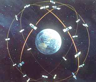
SATELLITE CONSTELLATION
In March 1996, the White
House announced that a higher level of GPS accuracy will be made
available to everyone, and the practice of degrading civil GPS signals
will be phased out within a decade. The White House also reaffirmed
the federal government's commitment to providing GPS services for
peaceful civil, commercial, and scientific use on a worldwide basis
and free of charge.
GLONASS - The Global Navigation Satellite System (GLONASS), being deployed by the Russian Federation, has much in common with the U. S.' Global Positioning System (GPS) in terms of the satellite constellation, orbits, and signal structure. Both systems are owned and operated by their respective defense departments, and offer precise, global, and continuous position-fixing capabilities. Both transmit spread spectrum signals at two frequencies in the L-band (1.2 GHz and 1.6 GHz), and have pledged to make a partial set of signals available for civil use without any user fees for the next 10 years, or more.
›
Trilateration
Basics
GPS CAPABILITIES
The GPS is a US DoD developed, worldwide, satellite-based radionavigation system that will be the DoD's primary radionavigation system well into the next century. The constellation consists of 24 operational satellites. The U.S. Air Force Space Command (AFSC) formally declared the GPS satellite constellation as having met the requirement for Full Operational Capability (FOC) as of April 27, 1995. Requirements include 24 operational satellites (Block II/IIA) functioning in their assigned orbits and successful testing completed for operational military functionality. Prior to FOC an Initial Operational Capability (IOC) was declared on December 8, 1993 when 24 GPS satellites (Block I and Block II/IIA) were operating in their assigned orbits, available for navigation use and providing the Standard Positioning Service (SPS) levels specified below.
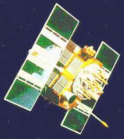
SOLAR POWERED NAVSTAR SATELLITE
GPS provides two levels of service, Standard Positioning Service and the Precise Positioning Service .
For questions regarding GPS policy, the user is advised to refer to the regularly appearing FRP. The FRP is published every 2 years and is available from the National Technical Information Service, Springfield, VA 22161. The latest report number is DOT-VNTSC-RSPA-95-1/DOD-4650.5 for report date 1994.
GPS SIGNAL CHARACTERISTICS
The satellites transmit on two L-band frequencies: L1 = 1575.42 MHz and L2 = 1227.6 MHz. Three pseudo-random noise (PRN) ranging codes are in use.
The C/A code is available on the L1 frequency and the P-code is available on both L1 and L2. The various satellites all transmit on the same frequencies, L1 and L2, but with individual code assignments.
Due to the spread spectrum characteristic of the signals, the system provides a large margin of resistance to interference. Each satellite transmits a navigation message containing its orbital elements, clock behavior, system time and status messages. In addition, an almanac is also provided which gives the approximate data for each active satellite. This allows the user set to find all satellites once the first has been acquired.
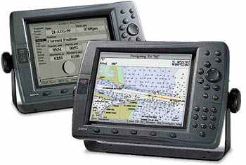
MARINE GPS INSTRUMENT DISPLAY
ERRORS
GPS errors are a combination of noise, bias, blunders. Noise errors are the combined effect of PRN code noise (around 1 meter) and noise within the receiver noise (around 1 meter). Bias errors result from Selective Availability and other factors. SA is the intentional degradation of the SPS signals by a time varying bias. SA is controlled by the DOD to limit accuracy for non-U. S. military and government users. The potential accuracy of the C/A code of around 30 meters is reduced to 100 meters (two standard deviations).
SELECTIVE AVAILABILITY, ANTI-SPOOFING
Selective Availability (SA), the denial of full accuracy, is accomplished by manipulating navigation message orbit data (epsilon) and/or satellite clock frequency (dither). Anti-spoofing (A-S) guards against fake transmissions of satellite data by encrypting the P-code to form the Y-code. SA will be implemented on Block II at the SPS levels, as soon as each Block II satellite is operational. SA was activated July 4, 1991 at 0400 UT (ref: Notice Advisory to NAVSTAR Users 121-92282 DTG 011354Z JUL 91 ). A-S was exercised intermittently through 1993 and implemented on January 31, 1994.
GPS SYSTEM SEGMENTS
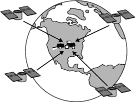
The GPS consists of three major segments: SPACE, CONTROL and USER. The Space hardware of the system consists of the GPS satellites orbiting Earth, forming an artificial constellation of man made objects. These space vehicles send radio signals from space to Earth for land based decoding. The SPACE segment consists of 24 operational satellites in six orbital planes (four satellites in each plane) with 3 spares, totaling 27 satellites in all. The satellites operate in circular 20,200 km (10,900 nm) orbits at an inclination angle of 55 degrees and with a 12-hour period. The position is therefore the same at the same sidereal time each day, i.e. the satellites appear 4 minutes earlier each day. The orbit altitude is such that the satellites repeat the same track and configuration over any point approximately each 24 hours. This constellation provides the land based user with between 5 to 8 visible satellites from any point on earth. The Navstar satellite shown on this page weighs 3,000 to 4,000 lbs and is powered by a solar panel array.
The CONTROL segment consists of five Monitor Stations (Hawaii, Kwajalein, Ascension Island, Diego Garcia, Colorado Springs), three Ground Antennas, (Ascension Island, Diego Garcia, Kwajalein), and a Master Control Station (MCS) located at Schriever Air Foce Base in Colorado USA. The monitor stations passively track all satellites in view, accumulating ranging data. This information is processed at the MCS to determine satellite orbits and to update each satellite's navigation message. Updated information is transmitted to each satellite via the Ground Antennas. These 5 monitoring stations measure signals from the satellite constellation. The models compute precise orbital data and clock corrections for each satellite. The Master Control station uploads clock data to the satellites then send subsets of the orbital data to GPS receivers over radio signals. The satellites transmit two microwave carrier signals. The L1 frequency (1575.42 MHz) carries the navigation message and the SPS code signals. The L2 frequency (1227.60 MHz) is used to measure the ionospheric delay by PPS equipped receivers.
The USER segment consists of antennas and receiver-processors that provide positioning, velocity, and precise timing to the user community. GPS receivers convert SV signals into position, velocity, and time estimates. Four satellites are required to compute the four dimensions of X, Y, Z (position) and Time. GPS receivers are used for marine and land based navigation, and time and location for orienteering.
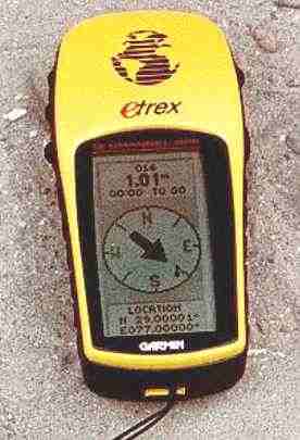
GPS HANDHELD RECEIVER
GPS SYSTEM TIME
GPS system time is given by its Composite Clock (CC). The CC or "paper" clock consists of all operational Monitor Station and satellite frequency standards. GPS system time, in turn, is referenced to the Master Clock (MC) at the USNO and steered to UTC(USNO) from which system time will not deviate by more than one microsecond. The exact difference is contained in the navigation message in the form of two constants, A0 and A1, giving the time difference and rate of system time against UTC(USNO,MC). UTC(USNO) itself is kept very close to the international benchmark UTC(BIPM), and the exact difference, USNO vs. BIPM is available in near real time.
The latest individual satellite measurements are updated daily. (Data format explanation.) The best current measure of the difference, UTC(USNO MC) - GPS is based on filtered and smoothed data over the past two days. GPS DATA
The GPS Navigation Message consists of time-tagged data bits marking the time of transmission of each subframe at the time they are transmitted by the SV. A data bit frame consists of 1500 bits divided into five 300-bit subframes. A data frame is transmitted every thirty seconds. Three six-second subframes contain orbital and clock data. SV Clock corrections are sent in subframe one and precise SV orbital data sets (ephemeris data parameters) for the transmitting SV are sent in subframes two and three. Subframes four and five are used to transmit different pages of system data. An entire set of twenty-five frames (125 subframes) makes up the complete Navigation Message that is sent over a 12.5 minute period.
GPS TIME TRANSFER
GPS is at the present time the most competent system for time transfer , the distribution of Precise Time and Time Interval (PTTI). The system uses time of arrival (TOA) measurements for the determination of user position. A precisely timed clock is not essential for the user because time is obtained in addition to position by the measurement of TOA of FOUR satellites simultaneously in view. If altitude is known (i.e. for a surface user), then THREE satellites are sufficient. If time is being kept by a stable clock (say, since the last complete coverage), then TWO satellites in view are sufficient for a fix at known altitude. If the user is, in addition, stationary or has a known speed then, in principle, the position can be obtained by the observation of a complete pass of a SINGLE satellite. This could be called the "transit" mode, because the old TRANSIT system uses this method. In the case of GPS, however, the apparent motion of the satellite is much slower, requiring much more stability of the user clock.
SURVEYING
Carrier-phase tracking of GPS signals has resulted in a revolution in land surveying. A line of sight along the ground is no longer necessary for precise positioning, such as crop spraying. Positions can be measured up to 30 km from reference point without intermediate points. This use of GPS requires specially equipped carrier tracking receivers. The L1 and/or L2 carrier signals are used in carrier phase surveying. L1 carrier cycles have a wavelength of 19 centimeters. If tracked and measured these carrier signals can provide ranging measurements with relative accuracies of millimeters under special circumstances.
FARMERS USE GPS FOR SPRAYING
COSTS
Receiver costs vary depending on capabilities. Small civil SPS receivers can be purchased for under $200, some can accept differential corrections. Receivers that can store files for post-procesing with base station files cost more ($2000-5000). Receivers that can act as DGPS reference receivers (computing and providing correction data) and carrier phase tracking receivers (and two are often required) can cost many thousands of dollars ($5,000 to $40,000). Military PPS receivers may cost more or be difficult to obtain.
Global Positioning System (GPS) information is obtained from the 1994 Federal Radionavigation Plan (FRP), prepared jointly by the US Department of Defense (DoD) and the Department of Transportation (DoT) and other sources such as conferences, meetings and seminars. USNO GPS DATA FILES
New energy drinks for performers
.. Thirst for Life
330ml Earth can - the World in Your Hands
|
||||||||||
|
This
website
is Copyright © 1999 & 2008 NJK. The bird |
||||||||||
|
AUTOMOTIVE | BLUEBIRD | ELECTRIC CARS | ELECTRIC CYCLES | SOLAR CARS |