Air traffic control (ATC) is a service provided by ground-based controllers who direct aircraft on the ground and through controlled airspace. The primary purpose of ATC systems worldwide is to separate aircraft to prevent collisions, to organize and expedite the flow of traffic, and to provide information and other support for pilots when
able. In some countries, ATC may also play a security or defense role, or be run entirely by the military.
Preventing collisions is referred to as separation, which is a term used to prevent aircraft from coming too close to each other by use of lateral, vertical and longitudinal separation minima. Many aircraft now have collision avoidance systems installed to act as a backup to ATC observation and instructions. In addition to its primary function, the ATC can provide additional services such as providing information to pilots, weather and navigation information and NOTAMs (Notices To
AirMen).
In many countries, ATC services are provided throughout the majority of airspace, and its services are available to all users (private, military, and commercial). When controllers are responsible for separating some or all aircraft, such airspace is called "controlled airspace" in contrast to "uncontrolled airspace" where aircraft may fly without the use of the air traffic control system. Depending on the type of flight and the class of airspace, ATC may issue instructions that pilots are required to follow, or merely flight information (in some countries known as advisories) to assist pilots operating in the airspace. In all cases, however, the pilot in command has final responsibility for the safety of the flight, and may deviate from ATC instructions in an emergency.
Croydon
airport near London was the first to introduce air traffic control in
1921.
VISUAL
OBSERVATION
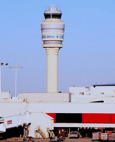
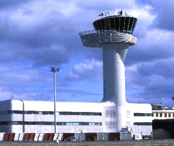
The primary method of controlling the immediate airport environment is visual observation from the aerodrome control tower (TWR). The TWR is a tall, windowed structure located on the airport grounds. Aerodrome or Tower controllers are responsible for the separation and efficient movement of aircraft and vehicles operating on the taxiways and runways of the airport itself, and aircraft in the air near the airport, generally 5 to 10 nautical miles (9 to 18 km) depending on the airport procedures.
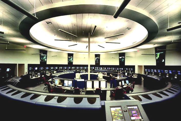
Radar displays are also available to controllers at some airports. Controllers may use a radar system called Secondary Surveillance Radar for airborne traffic approaching and departing. These displays include a map of the area, the position of various aircraft, and data tags that include aircraft identification, speed, altitude, and other information described in local procedures. In adverse weather conditions the tower controllers may also use Surface Movement Radar (SMR), Surface Movement Guidance and Control Systems (SMGCS) or Advanced SMGCS to control traffic on the manoeuvring area (taxiways and runways).
The areas of responsibility for TWR controllers fall into three general operational disciplines; Local Control or Air Control, Ground Control, and Flight Data/Clearance Delivery—other categories, such as Apron Control or Ground Movement Planner, may exist at extremely busy airports. While each TWR may have unique airport-specific procedures, such as multiple teams of controllers ('crews') at major or complex airports with multiple runways, the following provides a general concept of the delegation of responsibilities within the TWR environment.
Remote and Virtual Tower (RVT) is a system based on Air Traffic Controllers being located somewhere other than at the local airport tower and still able to provide Air Traffic Control services. Displays for the Air Traffic Controllers may be either optical live video and/or synthetic images based on surveillance sensor data.
Ground control
Ground Control (sometimes known as Ground Movement Control abbreviated to GMC or Surface Movement Control abbreviated to SMC) is responsible for the airport "movement" areas, as well as areas not released to the airlines or other users. This generally includes all taxiways, inactive runways, holding areas, and some transitional aprons or intersections where aircraft arrive, having vacated the runway or departure gate. Exact areas and control responsibilities are clearly defined in local documents and agreements at each airport. Any aircraft, vehicle, or person walking or working in these areas is required to have clearance from Ground Control. This is normally done via VHF/UHF radio, but there may be special cases where other processes are used. Most aircraft and air-side vehicles have radios. Aircraft or vehicles without radios must respond to ATC instructions via aviation light signals or else be led by vehicles with radios. People working on the airport surface normally have a communications link through which they can communicate with Ground Control, commonly either by handheld radio or even cell phone. Ground Control is vital to the smooth operation of the airport, because this position impacts the sequencing of departure aircraft, affecting the safety and efficiency of the airport's operation.
Some busier airports have Surface Movement Radar (SMR), such as, ASDE-3, AMASS or ASDE-X, designed to display aircraft and vehicles on the ground. These are used by Ground Control as an additional tool to control ground traffic, particularly at night or in poor visibility. There are a wide range of capabilities on these systems as they are being modernized. Older systems will display a map of the airport and the target. Newer systems include the capability to display higher quality mapping, radar target, data blocks, and safety alerts, and to interface with other systems such as digital flight strips.
Local control or air control
Local Control (known to pilots as "Tower" or "Tower Control") is responsible for the active runway surfaces. Local Control clears aircraft for takeoff or landing, ensuring that prescribed runway separation will exist at all times. If Local Control detects any unsafe condition, a landing aircraft may be told to "go-around" and be re-sequenced into the landing pattern by the approach or terminal area controller.
Within the TWR, a highly disciplined communications process between Local Control and Ground Control is an absolute necessity. Ground Control must request and gain approval from Local Control to cross any active runway with any aircraft or vehicle. Likewise, Local Control must ensure that Ground Control is aware of any operations that will impact the taxiways, and work with the approach radar controllers to create "holes" or "gaps" in the arrival traffic to allow taxiing traffic to cross runways and to allow departing aircraft to take off. Crew Resource Management (CRM) procedures are often used to ensure this communication process is efficient and clear, although this is not as prevalent as CRM for pilots.
Flight traffic mapping
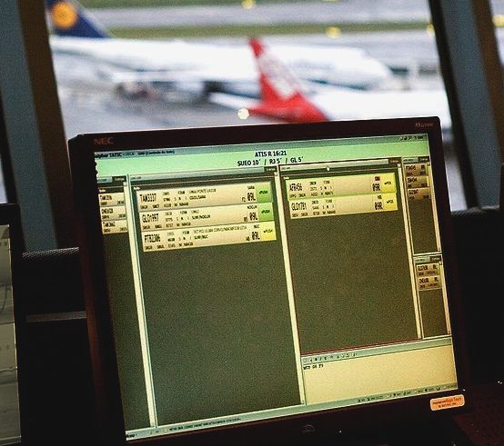
The mapping of flights in real-time is based on the air traffic control system. In 1991, data on the location of aircraft was made available by the Federal Aviation Administration to the airline industry. The National Business Aviation Association (NBAA), the General Aviation Manufacturers Association, the Aircraft Owners & Pilots Association, the Helicopter Association International, and the National Air Transportation Association petitioned the FAA to make ASDI information available on a "need-to-know" basis.
Subsequently, NBAA advocated the broad-scale dissemination of air traffic data. The Aircraft Situational Display to Industry (ASDI) system now conveys up-to-date flight information to the airline industry and the public. Some companies that distribute ASDI information are FlightExplorer, FlightView, and FlyteComm. Each company maintains a website that provides free updated information to the public on flight status. Stand-alone programs are also available for displaying the geographic location of airborne IFR (Instrument Flight Rules) air traffic anywhere in the FAA air traffic system. Positions are reported for both commercial and general aviation traffic. The programs can overlay air traffic with a wide selection of maps such as, geo-political boundaries, air traffic control center boundaries, high altitude jet routes, satellite cloud and radar imagery.
Problems
Traffic
The day-to-day problems faced by the air traffic control system are primarily related to the volume of air traffic demand placed on the system and weather. Several factors dictate the amount of traffic that can land at an airport in a given amount of time. Each landing aircraft must touch down, slow, and exit the runway before the next crosses the approach end of the runway. This process requires at least one and up to four minutes for each aircraft. Allowing for departures between arrivals, each runway can thus handle about 30 arrivals per hour. A large airport with two arrival runways can handle about 60 arrivals per hour in good weather. Problems begin when airlines schedule more arrivals into an airport than can be physically handled, or when delays elsewhere cause groups of aircraft that would otherwise be separated in time to arrive simultaneously. Aircraft must then be delayed in the air by holding over specified locations until they may be safely sequenced to the runway. Up until the 1990s, holding, which has significant environmental and cost implications, was a routine occurrence at many airports. Advances in computers now allow the sequencing of planes hours in advance. Thus, planes may be delayed before they even take off (by being given a "slot"), or may reduce speed in flight and proceed more slowly thus significantly reducing the amount of holding.
Air traffic control errors occur when the separation (either vertical or horizontal) between airborne aircraft falls below the minimum prescribed separation set (for the domestic United States) by the US Federal Aviation Administration. Separation minimums for terminal control areas (TCAs) around airports are lower than en-route standards. Errors generally occur during periods following times of intense activity, when controllers tend to relax and overlook the presence of traffic and conditions that lead to loss of minimum
separation. Paradoxically, current high precision cruising altitude rules increase the risk of collision between 10 and 33 times over more sloppy alternatives when air traffic control errors occur.
Weather
Beyond runway capacity issues, weather is a major factor in traffic capacity. Rain, ice or snow on the runway cause landing aircraft to take longer to slow and exit, thus reducing the safe arrival rate and requiring more space between landing aircraft. Fog also requires a decrease in the landing rate. These, in turn, increase airborne delay for holding aircraft. If more aircraft are scheduled than can be safely and efficiently held in the air, a ground delay program may be established, delaying aircraft on the ground before departure due to conditions at the arrival airport.
In Area Control Centers, a major weather problem is thunderstorms, which present a variety of hazards to aircraft. Aircraft will deviate around storms, reducing the capacity of the en-route system by requiring more space per aircraft, or causing congestion as many aircraft try to move through a single hole in a line of thunderstorms. Occasionally weather considerations cause delays to aircraft prior to their departure as routes are closed by thunderstorms.
Much money has been spent on creating software to streamline this process. However, at some ACCs, air traffic controllers still record data for each flight on strips of paper and personally coordinate their paths. In newer sites, these flight progress strips have been replaced by electronic data presented on computer screens. As new equipment is brought in, more and more sites are upgrading away from paper flight strips.
Call signs
A prerequisite to safe air traffic separation is the assignment and use of distinctive call signs. These are permanently allocated by ICAO (pronounced "ai-kay-oh") on request usually to scheduled flights and some air forces for military flights. They are written callsigns with 3-letter combination like KLM, BAW, VLG followed by the flight number, like AAL872, VLG1011. As such they appear on flight plans and ATC radar labels. There are also the audio or Radio-telephony callsigns used on the radio contact between pilots and Air Traffic Control not always identical with the written ones. For example BAW symbolises British Airways but on the radio you will only hear the word Speedbird followed by an alpha-numeric code instead. By default, the callsign for any other flight is the registration number (tail number) of the aircraft, such as "N12345", "C-GABC" or "EC-IZD". The term tail number is because a registration number is usually painted somewhere on the tail of a plane, yet this is not a rule. Registration numbers may appear on the engines, anywhere on the fuselage, and often on the wings. The short Radio-telephony callsigns for these tail numbers is the last 3 letters only like ABC spoken Alpha-Bravo-Charlie for C-GABC or the last 3 numbers like 345 spoken as TREE-FORE-FIFE for N12345. In the United States the abbreviation of callsigns is required to be a prefix (such as aircraft type, aircraft manufacturer, or first letter of registration) followed by the last three characters of the callsign. This abbreviation is only allowed after communications has been established in each sector.
The flight number part is decided by the aircraft operator. In this arrangement, an identical call sign might well be used for the same scheduled journey each day it is operated, even if the departure time varies a little across different days of the week. The call sign of the return flight often differs only by the final digit from the outbound flight. Generally, airline flight numbers are even if eastbound, and odd if westbound. In order to reduce the possibility of two callsigns on one frequency at any time sounding too similar, a number of airlines, particularly in Europe, have started using alphanumeric callsigns that are not based on flight numbers. For example DLH23LG, spoken as lufthansa-two-tree-lima-golf. Additionally it is the right of the air traffic controller to change the 'audio' callsign for the period the flight is in his sector if there is a risk of confusion, usually choosing the tail number instead.
Before around 1980 International Air Transport Association (IATA) and ICAO were using the same 2-letter callsigns. Due to the larger number of new airlines after deregulation ICAO established the 3-letter callsigns as mentioned above. The IATA callsigns are currently used in aerodromes on the announcement tables but never used any longer in Air Traffic Control. For example, AA is the IATA callsign for American Airlines — ATC equivalent AAL. Other examples include LY/ELY for El Al, DL/DAL for Delta Air Lines, VY/VLG for Vueling Airlines, etc.
LINKS
Air
Traffic Control Career Prep
Civil
Air Navigation Services Organisation (CANSO)
The
ATC Network – The online portal for ATC professionals
ATC-SIM
– A web-based air traffic control simulator
International
Federation of Air Traffic Safety Electronics Associations
atcosonline
– A community based site for air traffic controllers from around the
world
U.S.
Centennial of Flight Commission – Air Traffic Control
A
TRAVELER MEETS AIR TRAFFIC CONTROL (1963)
SKYbrary:
The single point of reference in the network of aviation safety knowledge
Listen
to ATC radio 24/7 Live Aviation Radio
Listen
to GERMAN ATC (NRW) radio 24/7 Live Aviation Radio
Map
of airborne flights controlled by US ATC
OpsRoom
– Worldwide FIRs, Live ATC/airspace data
Audio
of interview with US terminal area controller
Air
traffic in 24 hours
Control
Tower Technical Aspects