|
Hosum Star Globe by H. Hughes of London |
||||
|
HOME BIOLOGY CREW GEOGRAPHY HISTORY INDEX MUSIC THE BOAT SOLAR CELLS SPONSORS |
||||
|
Hosum Star Globe by H. Hughes of London - dated around 1920.
These globes were used by the ship's navigator, in conjunction with his sextant, to plot the ship's position at night. In modern times of satellite navigation this is a timely and decorative reminder of days gone by and is a handsome quality crafted piece to grace any maritime collection.
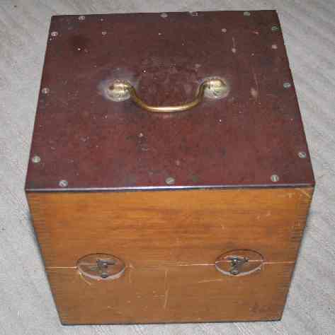
Hosum Star Globe - Deck box closed
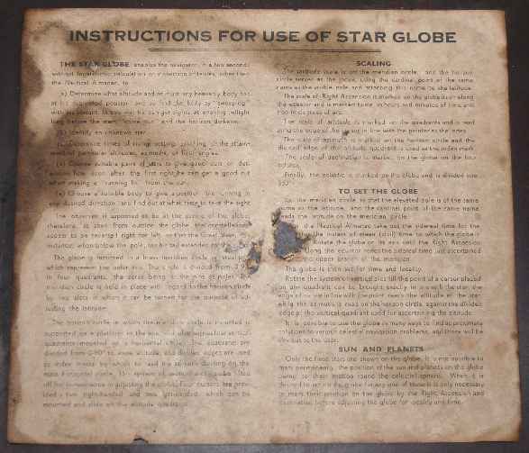
The instrument is in original un-restored condition and is mounted in a wooden deck box with spring latch closures. Box size 27cm (10.5”). The instructions in the lid are stained with damage to the centre. It is possible to restore this paperwork.
Hosum Star Globe by H. Hughes of London - Instructions
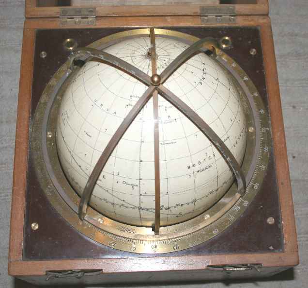
Hosum Star Globe - showing globe and brass arcs
Offered invited around £3,500 - please email for details or to arrange viewing in Sussex England. Nelson Kruschandl +44 (0) 7905 147709
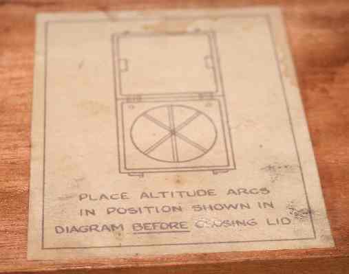
Hosum Star Globe - lid closing directions
NAVIGATION EARLY HISTORY
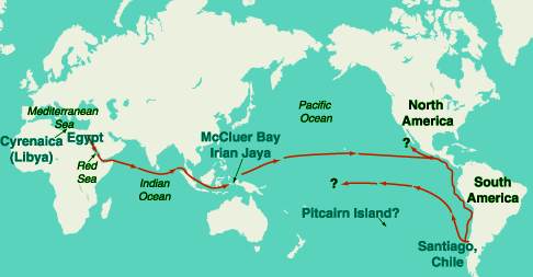
Around the year 232 B.C., Captain Rata and Navigator Maui set out with a flotilla of ships from Egypt in an attempt to circumnavigate the Earth. It has been proved in principle that Captain Rata and Navigator Maui could have known and charted their location, by longitude, most of the time during that voyage.
The Maui expedition was under the guidance of Eratosthenes, the great scientist who was also the chief librarian of the library at Alexandria. It is argued that this voyage could have demonstrated Eratosthenes' theorem that the world was round, and measured approximately 24,500 miles in circumference? One of the navigational instruments which Maui had with him was a strange looking "calculator" that he called a tanawa; such an instrument was known, in 1492, as a torquetum. This is the forerunner of many navigation instruments, such as the Star Globe offered for sale above.
There is a cave drawing of that tanawa in Irian Jaya, western New Guinea. It has been suggested that Maui must have been looking at the ecliptic to measure "lunar distance," in order to find his longitude. Maui's tanawa was of such importance, that he drew it on the cave wall with the inscription, deciphered in the 1970s by epigrapher Barry Fell: "The Earth is tilted. Therefore, the signs of half of the ecliptic watch over the south, the other (half) rise in the ascendant. This is the calculator of Maui." Eratosthenes had just measured the circumference of the Earth, and the circumference of a sphere is the same in all directions. We can guess that Maui was thinking about this, because his cave drawings also include a proof of Eratosthenes' experiment to measure the Earth's circumference.
PROBABLE ROUTE OF THE EGYPTIAN VOYAGE IN 232 B.C.
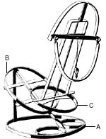
Brass reconstruction of Maui's tanawa by Dr. Sentiel Rommel C. 1970. The base (A) in the plane of the observer's horizon is oriented so that the axis of symmetry is parallel to the meridian. (B) is the equatorial plane. (C) is the ecliptic plane (viewed from one side in Maui's drawing, thus appearing as a line).
In 1502 Amerigo Vespucci said in a letter : ". . . I maintain that I learned [my longitude] . . . by the eclipses and conjunctions of the Moon with the planets; and I have lost many nights of sleep in reconciling my calculations with the precepts of those sages who have devised the manuals and written of the movements, conjunctions, aspects, and eclipses of the two luminaries and of the wandering stars, such as the wise King Don Alfonso in his Tables, Johannes Regiomontanus in his Almanac, and Blanchinus, and the Rabbi Zacuto in his almanac, which is perpetual; and these were composed in different meridians: King Don Alfonso's book in the meridian of Toledo, and Johannes Regiomontanus's in that of Ferrara, and the other two in that of Salamanca."2 The best "clock" to use for reference, is the stars. In the roughly 27.3 solar days of a lunar orbit, the Moon moves a full 360 degrees around the sky, returning to its old position among the stars. This is 13 degrees per day, or just over 0.5 degree per hour. So, while the rotation of the Earth causes the stars and the Moon to appear to move from east to west across the night sky, the Moon, because of its own orbit around the Earth, fights back against this apparent motion, and seems to move eastward (or retrograde) by about 0.5 degree per hour. In other words, the Moon "moves" west only 11.5 degrees per hour.
References:
"On Eratosthenes, Maui's Voyage of Discovery, and Reviving the Principle of Discovery Today," by Lyndon H. LaRouche, Jr., 21st Century, Spring 1999, p. 24;
"Eratosthenes' Instruments Guided Maui's 3rd Century B.C. Voyage," by Marjorie Mazel Hecht, 21st Century, Spring 1999, p. 74;
"Maui's Tanawa: A Torquetum of 232 B.C.," by Sentiel Rommel, Ph.D., 21st Century, Spring 1999, p. 75.
ORIGINAL 'GALLAHER' WARTIME CIGARETTE CARDS - COMPLETE SET OFFERS INVITED
POUNDGATES MARINE INSURANCE
Nelson says: "We all need insurance to protect our investments. So, why don't you give the Lloyds broker: Poundgates a try online."
Move up to a better service and help keep this project funded. For every policy sold through us, Poundgates will make a generous contribution to our project.
FOR YOUR NO OBLIGATION QUOTE: Email: Nelson Kruschandl ENCLOSING DETAILS OF YOUR VESSEL, OR CARGO AND THE PLANNED JOURNEY OR DESTINATION. YOU WILL THEN BE CONTACTED BY A SPECIALIST WHO WILL GUIDE YOU THOUGH THE PROCESS.
Should you have any difficulty using this service please contact Nelson Kruschandl:
|
||||
|