|
TSUNAMI - HISTORY and DESCRIPTION |
||||||||||||||||||
|
SITE INDEX CATAMARAN HULL SOLAR PANELS ELECTRIC MOTORS BATTERIES CREW EXPEDITION MUSIC GOODIES |
||||||||||||||||||
|
A tsunami (津波 or 津浪, often pronounced in English as 'su-na-mi' or 'tsu-na-mi' is a natural phenomenon consisting of a series of waves generated when water in a lake or the sea is rapidy displaced on a massive scale. Earthquakes, landslides, volcanic eruptions, and the impact of extraterrestrial bodies such as meteorites, can generate tsunamis which can rapidly and violently inundate coastlines, causing devastating property damage, injuries, and loss of life.
The term "tsunami" comes from the Japanese language meaning harbour ("tsu"/津) and wave ("nami"/波/浪). The term was created by fishermen who returned to port to find the area surrounding the harbour devastated, although they had not been aware of any wave in the open water. A tsunami is not a sub-surface event in the deep ocean; it simply has a much smaller amplitude (wave heights) offshore, and a very long wavelength (often hundreds of kilometers long), which is why they generally pass unnoticed at sea, forming only a passing "hump" in the ocean.
Tsunamis were historically referred to as tidal waves because as they approach land they take on the characteristics of a violent onrushing tide, rather than the sort of cresting waves that are formed by wind action upon the ocean (with which people are more familiar). However, as they are not actually related to tides, the term is considered misleading, and its use is deprecated by oceanographers.
TSUNAMI LINKS: DESCRIPTION & HISTORY | AFTERMATH AID & MESSAGES | DECEMBER 30 2004 | DECEMBER 27 2004
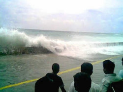
The tsunami that struck Malé in the Maldives on December 26, 2004.
CAUSES
A tsunami can be generated by any disturbance that displaces a large mass of water, such as an earthquake, landslide or meteor impact. However, the most common cause is an undersea earthquake. An earthquake which is too small to create a tsunami by itself may trigger an undersea landslide quite capable of generating a tsunami.
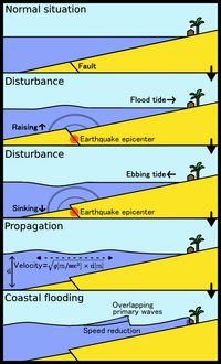
Tsunamis can be generated when the sea floor abruptly deforms and vertically displaces the overlying water. Large vertical movements of the earth's crust can occur at plate boundaries. Denser oceanic plates slip under continental plates in a process known as subduction; subduction earthquakes are particularly effective in generating tsunamis.
Submarine landslides (which sometimes accompany large earthquakes) as well as collapses of volcanic edifices, can also disturb the overlying water column as sediment and rocks slump downslope and are redistributed across the sea floor. Similarly, a violent submarine volcanic eruption can uplift a water column and generate a tsunami.
Waves are formed as the displaced water mass moves under the influence of gravity to regain its equilibrium and radiates across the ocean like ripples on a pond.
Large landslides and cosmic-body impacts can disturb the water from above, as momentum from falling debris is transferred to the water into which the debris falls. Generally speaking, tsunamis generated from these mechanisms—unlike the ocean-wide tsunamis caused by some earthquakes—dissipate quickly and rarely affect coastlines distant from the source area, due to the small area of sea affected. However, huge displacements caused by exceptionally large landslides or bolide impacts can cause megatsunamis that are far larger, and potentially much more devastating, than an ordinary tsunami. The largest known in recent times occurred in Lituya Bay, Alaska in July 1958 after a massive landslide, with a wave height estimated at 520 m (1700 ft).
Tsunami shock wave sequence
CHARACTERISTICS
Tsunamis act very differently from typical surf swells; they propagate at high speeds and can travel great transoceanic distances with little energy loss. A tsunami can cause damage thousands of kilometres from its origin, so there may be several hours between its creation and its impact on a coast, arriving long after the seismic wave generated by the originating event arrives.
In open water, tsunamis have extremely long periods (the time for the next wave top to pass a point after the previous one), from minutes to hours, and long wavelengths of up to several hundred kilometres. (Compare to the typical wind-generated swell one sees at a beach, which might be spawned by a faraway storm and rhythmically roll in, one wave after another, with a period of about 10 seconds and a wavelength of 150 m). The actual height of a tsunami wave in open water is often less than one metre. This is often practically unnoticeable to people on ships. The energy of a tsunami passes through the entire water column to depths of 4000 m or more, unlike surface waves, which typically reach only 10 m or so. The wave travels across the ocean at speeds from 500 to 1000 km/h, so the second or third waves may not arrive until more than an hour later. As the wave approaches land, the sea shallows and the wave no longer travels as quickly, so it begins to 'pile-up': the wave becomes steeper and taller, and there is less distance between crests. While a person at the surface of deep water would probably not even notice the tsunami, the wave can increase to a height of 30 m or more as it approaches the coastline and compresses.
A wave becomes a 'shallow-water wave' when the ratio between the water depth and its wavelength gets very small, and since a tsunami has an extremely large wavelength (hundreds of kilometres), tsunamis act as a shallow-water wave even in deep oceanic water. Shallow-water waves move at a speed that is equal to the square root of the product of the acceleration of gravity (9.8 m/s2) and the water depth. For example, in the Pacific Ocean, where the typical water depth is about 4000 m, a tsunami travels at about 200 m/s (720 km/h or 450 mi/h) with little energy loss, even over long distances. At a water depth of 40 m, the speed would be 20 m/s (about 72 km/h or 45 mi/h), which is much slower than the speed in the open ocean but the wave would still be difficult to outrun.
As it approaches the shore, a tsunami does not appear as a single wave like an ordinary surface wave but instead looks rather like an onrushing tide - hence the old name of "tidal wave". Most of the damage is caused by the huge mass of water behind the initial wave front. The sheer weight of water is enough to pulverise objects in its path, often reducing buildings to their foundations and scouring exposed ground to the bedrock. Large objects such as ships and boulders can be carried several miles inland before the tsunami subsides.
Tsunamis propagate outward from their source, so coasts in the "shadow" of affected land masses are usually fairly safe. However, tsunami waves can diffract around land masses (as shown in this Indian Ocean tsunami animation as the waves reach southern Sri Lanka and India). They also need not be symmetrical; tsunami waves may be much stronger in one direction than another, depending on the nature of the source and the surrounding geography.
Local geographic peculiarities can lead to seiche or standing waves forming, which can amplify the onshore damage. For instance, the tsunami that hit Hawaii on April 1, 1946 had a fifteen-minute interval between wave fronts. The natural resonant period of Hilo Bay is about thirty minutes. That meant that every second wave was in phase with the motion of Hilo Bay, creating a seiche in the bay. As a result, Hilo suffered worse damage than any other place in Hawaii, with the tsunami/seiche reaching a height of 14 m and killing 159 inhabitants.
Tsunami wall at Tsu-shi, Japan
WARNINGS and PREVENTION
In instances where the leading edge of the tsunami wave is its trough, the sea will recede from the coast half of the wave's period before the wave's arrival. If the slope is shallow, this recession can exceed 800 m. People unaware of the danger may remain at the shore due to curiosity, or for collecting fish from the dry sea bottom.
In instances where the leading edge of the tsunami is its first peak, low-lying coastal areas are flooded before following waves reach them. Again, being educated about a tsunami is important, to realize that when the water level drops the first time, the danger is not yet over.
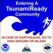
Regions with a high risk of tsunamis use tsunami warning systems to forecast tsunamis and warn the general population. On the west coast of the United States, which is prone to Pacific Ocean tsunamis, warning signs advise people where to run in the event of an incoming tsunami.
While it is of course not possible to prevent a tsunami, in some particularly tsunami-prone countries some measures have been taken to reduce the damage caused on shore. Japan has implemented an extensive programme of building tsunami walls of up to 4.5m (13.5 ft) high in front of populated coastal areas. Other localities have built floodgates and channels to redirect the water from incoming tsunamis. However, their effectiveness has been questioned, as tsunamis are often higher than the barriers. For instance, the tsunami which hit Hokkaido on July 12, 1993 created waves as much as 30m (90 ft) tall - as high as a 10-storey building. Although the port town of Aonae was completely surrounded by a tsunami wall, the waves washed right over the wall and destroyed all wood-frame structures in the area. The wall may have succeeded in slowing down and moderating the height of the tsunami but it did not prevent major destruction and loss of life.
PAST TSUNAMIS
See also List of historic tsunamis by death toll.
Tsunamis occur most frequently in the Pacific Ocean, but are a global phenomenon; they are possible wherever large bodies of water are found - including inland lakes. Each of the following tsunamis is also described, sometimes at much greater length, in its own article:
6100 B.C. and before
In the North Atlantic Ocean, the Storegga Slides were a major series of sudden underwater land movements over the course of tens of thousands of years .
1650 B.C. - Santorini
At some time between 1650 BC and 1600 BC (still debated), the volcanic Greek island Santorini erupted, causing a 100 m to 150 m high tsunami that devastated the north coast of Crete, 70 km (45 miles) away, and would certainly have eliminated every timber of the Minoan fleet along Crete's northern shore. Santorini is regarded as the most likely source for Plato's literary parable of Atlantis, and is believed by some scientists to have informed Great Flood accounts which were eventually recorded in Jewish, Christian, and Islamic texts.
1755 - Lisbon, Portugal
Tens of thousands of Portuguese who survived the great 1755 Lisbon earthquake were killed by a tsunami which followed minutes later. Many townspeople fled to the waterfront, believing the area safe from fires and from falling debris from aftershocks. Before the great wall of water hit the harbor, waters retreated, revealing lost cargo and forgotten shipwrecks.
The earthquake, tsunami, and subsequent fires killed more than a third of Lisbon's pre-quake population of 275,000. Historical records of explorations by Vasco da Gama and Christopher Columbus were lost, and countless buildings were destroyed (including most examples of Portugal's Manueline architecture). The destruction of Lisbon sharply checked the colonial ambitions of the Portuguese Empire. Europeans of the 18th century struggled to understand the disaster within religious and rational belief systems. Philosophers of the Enlightenment, notably Voltaire, wrote about the event. The philosophical concept of the sublime, as described by philosopher Immanuel Kant in the Observations on the Feeling of the Beautiful and Sublime, took inspiration in part from attempts to comprehend the enormity of the Lisbon quake and tsunami.
Many animals sensed danger and fled to higher ground before the water arrived. The Lisbon quake is the first documented case of such a phenomenon in Europe. The phenomenon was also noted in Sri Lanka in the 2004 Indian Ocean earthquake. Some scientists speculate that animals may have an ability to sense subsonic Rayleigh waves from an earthquake minutes or hours before a tsunami strikes shore.[1] (http://www.slate.com/id/2111608/)
1883 - Krakatoa explosive eruption
The island volcano of Krakatoa in Indonesia exploded with devastating fury in 1883, blowing its underground magma chamber partly empty so that much overlying land and seabed collapsed into it. A series of large tsunami waves was generated from the explosion, some reaching a height of over 40 meters above sea level. Tsunami waves were observed throughout the Indian Ocean, the Pacific Ocean, the American West Coast, South America, and even as far away as the English Channel. On the facing coasts of Java and Sumatra the sea flood went many miles inland and caused such vast loss of life that one area was never resettled but went back to the jungle and is now the Ujung Kulon nature reserve.
1946 - Pacific Tsunami
The Aleutian Island earthquake tsunami that killed 165 people on Hawaii and Alaska resulted in creation of tsunami warning system established in 1949 for Pacific Ocean area countries.
1960 - Chilean tsunami
The Great Chilean Earthquake, at magnitude 9.5 the largest earthquake ever recorded, off the coast of South Central Chile, generated one of the most destructive tsunamis of the 20th century. It spread across the entire Pacific Ocean, with waves measuring up to 25 meters high. When the tsunami hit Onagawa, Japan, almost 22 hours after the quake, a tide gauge recorded a wave height of 10 feet above high tide. The number of people killed by the earthquake and subsequent tsunami is estimated to be between 490 to 2,290.
1964 - Good Friday tsunami
After the magnitude 9.2 Good Friday Earthquake, tsunamis struck Alaska, British Columbia, California and coastal Pacific Northwest towns, killing 122 people. The tsunamis were up to 6 m tall, and killed 11 people as far away as Crescent City, California.
2004 - Indian Ocean tsunami
Animation of the 2004 Indonesian Tsunami
The magnitude 9.0 2004 Indian Ocean Earthquake triggered a series of lethal tsunamis on December 26, 2004 that killed roughly 165,000 people (more than 105,000 in Indonesia), making it the deadliest tsunami in recorded history. The tsunami killed people over an area ranging from the immediate vicinity of the quake in Indonesia, Thailand and the north-western coast of Malaysia to thousands of kilometres away in Bangladesh, India, Sri Lanka, the Maldives, and even as far as Somalia, Kenya and Tanzania in eastern Africa.
Unlike the Pacific Ocean, there is no organised alert service covering the Indian Ocean. This is in part due to the absence of major tsunami events since 1883 (the Krakatoa eruption), which killed 36,000 people. In light of the 2004 Indian Ocean tsunami, UNESCO and other world bodies have called for a global tsunami monitoring system.
OTHER HISTORICAL TSUNAMIS
Other tsunamis that have occurred include the following:
Other tsunamis in South Asia
North American and Caribbean Tsunami
Possible Tsunami
Source: NOAA National Weather Service Forecast Office (http://www.erh.noaa.gov/er/phi/reports/tsunami.htm)
FUTURE THREATS
In 2001, scientists predicted that a future eruption of the unstable Cumbre Vieja volcano in La Palma (an island of the Canary Islands) could cause a giant undersea landslide. Later research showed that the threat was less than had originally been theorized. The next volcanic eruption is expected in the second half of the 21st century, but it is not necessarily the eruption that causes an immediate landslide. In the worst case scenario, the western half of the island (weighing perhaps 500 billion tonnes) would catastrophically slide into the ocean. Such a landslide could cause a 100 m wave to devastate the coast of northwest Africa, with a 10-25 m tsunami reaching the east coast of North America 7-8 hours later causing massive coastal devastation and the deaths of perhaps thousands of people, threatening Miami, suburbs of New York, parts of Boston, and all coastal cities in between. ([3] (http://www.es.ucsc.edu/~ward/papers/La_Palma_grl.pdf), [4] (http://archives.cnn.com/2001/TECH/science/08/29/tidal.wave/)).
TsunamiReady" sign in Ocean Shores and Grays Harbor, Washington
SEE ALSO
External links
VIDEOS
2004_Indian_Ocean_Earthquake#Videos
All of these videos are free but some of them you need to install spy-ware to watch. :-
ANIMATIONS and PHOTOS also see 2004_Indian_Ocean_Earthquake#Photos
INFORMATION
REFERENCES
CONTACT: nelson@solarnavigator.net +44 (0) 7905 147709 (UK)
|
||||||||||||||||||
|
||||||||||||||||||
