|
THE NAVIGATIONAL COMPASS HISTORY
|
|
|
HOME | BIOLOGY | BOOKS | FILMS | GEOGRAPHY | HISTORY | INDEX | INVESTORS | MUSIC | NEWS | SOLAR BOATS | SPORT |
|
|
A compass (or mariner's compass) is navigational instrument for finding directions. It consists of a magnetised pointer free to align itself accurately with Earth's magnetic field. A compass provides a known reference direction which is of great assistance in navigation. The cardinal points are north, south, east and west. A compass can be used in conjunction with a clock and a sextant to provide a very accurate navigation capability. This device greatly improved maritime trade by making travel safer and more efficient.
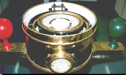
A compass can be any magnetic device using a needle to indicate the direction of the magnetic north of a planet's magnetosphere. Any instrument with a magnetized bar or needle turning freely upon a pivot and pointing in a northerly and southerly direction can be considered a compass. A compass dial is a small pocket compass with a sundial. A variation compass is a specific instrument of a delicate type of construction. It is used by observing variations of the needle. A gyrocompass can also be used to ascertain true North. History of the navigational compassCompasses were initially used in mysticism in ancient China. The first known use of Earth's magnetic field in this way occurred in ancient China as a spectacle. Arrows were cast similarly to dice. These magnetised arrows aligned themselves pointing north, impressing the audience. Curiously, it took some time for this trick to get used by the Chinese for naval navigation, but by the 11th or early 12th century it had become common. Knowledge of the compass moved overland to Europe sometime later in the 12th century. Arab mariners apparently learned of it from the Europeans, adopting its use in the first half of the 13th century. About 1358, there is a story about an English monk under the name Nicholas of Lynne, who served as a navigator due to his competence and knowledge in the "magnetic compass". (See Inventio Fortunata.) Prior to the introduction of the compass, wayfinding at sea was primarily done via celestial navigation, supplemented in some places by the use of soundings. Difficulties arose where the sea is too deep for soundings and conditions are continually overcast or foggy. Thus the compass was not of the same utility everywhere. For example, the Arabs could generally rely on clear skies in navigating the Persian Gulf and the Indian Ocean (as well as the predictable nature of the monsoons). This may explain in part their relatively late adoption of the compass. Mariners in the relatively shallow Baltic made extensive use of soundings. In the Mediterranean, however, the practice from ancient times had been to curtail sea travel between October and April, due in part to the lack of dependable clear skies during the Mediterranean winter (and much the sea is too deep for soundings). With improvements in dead reckoning methods, and the development of better charts, this changed during the second half the 13th century. By around 1290 the sailing season could start in late January or February, and end in December. The additional few months were of considerable economic importance; it enabled Venetian convoys, for instance, to make two round trips a year to the eastern Mediterranean, instead of one. Around the same time traffic between the Mediterranean and northern Europe increased, and one factor may be that the compass made traversal of the Bay of Biscay safer and easier. Construction of a simple compass A magnetic rod is required. This can be created by aligning an iron or steel rod with Earth's magnetic field and then tempering or striking it. However, this method produces only a weak magnet so other methods are preferred. This magnetised rod (or magnetic needle) is then placed on a low friction surface to allow it to freely pivot to align itself with the magnetic field. It is then labeled so the user can distinguish the north-pointing from the south-pointing end; in modern convention the north end is typically marked in some way, often by being painted red. Modern navigational compassesModern navigational compasses hold a magnetized needle inside a fluid-filled capsule; the fluid causes the needle to stop quickly rather than oscillate back and forth around magnetic north. Other features common on modern handheld compasses are a baseplate with rulings for measuring distances on maps, a rotating bezel for measuring bearings of distant objects, and a sighting mirror that lets the user see both the compass needle and a distant object at the same time. Mariner's compasses can have two or more magnetic needles permanently attached to a compass card. These move freely on a pivot. A lubber line, which can be a marking on the compass bowl or a small fixed needle indicates the ships heading on the compass card. Traditionally the card is divided into thirty-two points (known as rhumbs), although modern compasses are marked in degrees rather than cardinal points. The glass-covered box (or bowl) contains a suspended gimbal within a binnacle. This preserves the horizontal position. Large ships typically rely on a gyrocompass rather then a magnetic compass for navigation, and increasingly electronic fluxgate compasses are used on smaller vessels. Compass correctionA ship's compass must be corrected for errors, called compass deviation, caused by iron and steel in its structure and equipment. The ship is swung, that is rotated about a fixed point while its heading is noted by alignment with fixed points on the shore. A compass deviation card is prepared so that the navigator can convert between compass and magnetic headings. The compass can be corrected in three ways. First the lubber line can be adjusted so that it is aligned with the direction in which the ship travels, then the effects of permanent magnets can be corrected for by small magnets fitted within the case of the compass. The effect of non-ferromagnetic materials can be corrected by two iron balls mounted on either side of the compass binacle. The graph of the compass deviation can be understood using Fourier series. The coefficient a0 representing the error in the lubber line, while a1,b1 the ferromagnetic effects and a2,b2 the non-ferromagnetic component. Fluxgate compasses can be calibrated automatically, and can also be programmed with the correct local compass variation so as to indicate the true heading Points of the compassMain article: Boxing the compass The mariner's compass card is divided into thirty-two equally spaced points. Four of these - east, west, north, and south - are the cardinal points, and the names of the others are derived from these. See also: Azimuth, Beam compass, coordinates, fluxgate compass, gyrocompass, Gyrosin compass, gyrostatic compass, inertial navigation system, radio compass, radio direction finder External Links, Resources, and References
The Holy Compass is a John Storm adventure featuring the SolarNavigator and all the crew from previous adventures
New energy drinks for navigators
|
|
|
This website is Copyright © 1999 & 2012 NJK. The bird logos and name Solar Navigator are trademarks. All rights reserved. All other trademarks are hereby acknowledged. Max Energy Limited is an educational charity working hard for world peace. |
|
|
AUTOMOTIVE | BLUEPLANET | ELECTRIC CARS | ELECTRIC CYCLES | SOLAR CARS | SOLARNAVIGATOR |